

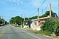

Village Chemax, Yucatán Municipality of Chemax Eastern Yucatán
Chemax's second-largest town, on the old free highway between Valladolid and Cancún near the Quintana Roo line, with a village church.
From Valladolid: 1 h by car (65 km by road) How to get there ↓
Near here
See everything nearby ↓


Plan your visit to X-Can
Where to stay near X-Can
Compare hotels, posadas and guest houses in X-Can.
Tours to X-Can
Day trips and guided outings from Valladolid often include X-Can; with a local guide you can get there without a car.
 Tours from Valladolid
Valladolid Mayan Bees Tour with Lunch or breakfast and Honey Tasting
★ 4.9 (205) · From US$22
How to get to X-Can
- From Valladolid: about 1 h by road (~65 km)
- Nearest airport: Tulum (TQO), 2 h by car to Valladolid
Links open a partner site. We may earn a commission if you book, at no cost to you.
Tours from Valladolid, near X-Can


Tours, prices and ratings from Viator, checked weekly. We may earn a commission if you book.
About X-Can
X-Can (pronounced roughly "ish-KAN") is a Maya town in the far east of Yucatán, in the municipality of Chemax, close to the state line with Quintana Roo. It sits on Federal Highway 180, the old free road between Valladolid and Cancún, about 64 km east of Valladolid by road and about 36 km northeast of the town of Chemax in a straight line. With 5,530 people in the 2020 census it is the second-largest place in the municipality after Chemax itself.
X-Can has grown fast. The census counted 194 people here in 1940 and 890 in 1950; by 1990 it passed 3,000, and it reached 5,191 in 2010. Like the rest of Chemax municipality, the area lived for centuries from maize, beans and other crops grown on the milpa, along with cattle and pigs; the municipality's own description notes that tourism has grown recently because it sits between Valladolid and the Caribbean coast. The list of archaeological sites recorded in Chemax municipality includes one named Xcan.
For a traveller, X-Can is mainly a place you pass through on the free highway, and a way to see an everyday town of the Maya east rather than a tourist stop. The town lies at about 25 m above sea level in flat, wooded country. The highway runs straight through town as a wide street lined with houses, and the village church, an ochre building with a stepped bell gable framed by palms, is the landmark to look for. It makes a natural break if you drive the slower free road between Cancún and Valladolid instead of the toll motorway.
How to get to X-Can
Drive from Valladolid: 1 h, 65 km
From Valladolid take Federal Highway 180 (the free road toward Cancún) east through Xalaú and Chemax; X-Can is on the highway about 64 km from Valladolid, roughly 1 hour of driving. From Cancún it is about 93 km (about 1 hour 15 minutes): take the 180D toll motorway west, then the free 180 back toward Valladolid. From Mérida, drive the 180D to Valladolid first (about 160 km).
Directions to X-Can on Google Maps
Distances are in a straight line; the road is usually longer.
Links open a partner site. We may earn a commission if you book, at no cost to you.
From the nearest cities to X-Can
- Valladolid · 65 km by road, 1 h
- Playa del Carmen · 74 km by road, 1 h
- Cancún · 96 km by road, 1 h 20 min
Drive times by road from OpenStreetMap, without traffic or stops. Times marked ~ are estimated from the straight-line distance.
Visiting X-Can: what to see and do
The ochre village church with its stepped bell gable.
Everyday life of a large Maya town of the Yucatán east.
A break on the free Highway 180 between Valladolid and Cancún.
Plan your trip
Places to stay in X-Can
Compare hotels, posadas, and rentals in and around X-Can.
Tours & activities
Day trips and guided outings from Valladolid often include X-Can; with a local guide you can get there without a car.
Rental cars
Pick up a car at TQO (Tulum): about 2 h by road to Valladolid, then 59 km more to X-Can, on your own schedule.
Flights
The nearest airport with scheduled flights is Tulum (TQO), about 2 h by road from Valladolid, the base for X-Can.
Mobile data
Signal can drop away from Valladolid: download a map of the way to X-Can before you set out, or carry an eSIM with data.
Links open a partner site. We may earn a commission if you book, at no cost to you.
Photos
When to go to X-Can warm
X-Can shares the climate of Valladolid, 59 km away. The best months to visit are January, February, November, and December.
See the month-by-month climate of Valladolid
Weather in X-Can now and the next 7 days
Live forecast from Open-Meteo. Chance of rain is the day's highest.
The closest Pueblo Mágico: Valladolid

Valladolid is the Pueblo Mágico closest to X-Can, with places to stay, food, and more to see.
Also close to
Closest to X-Can

Near X-Can




Drive times by road from OpenStreetMap, without traffic. Times marked ~ are estimated from the straight-line distance.
Location from OpenStreetMap. Written by Puebloteca.