City Chimalhuacán, Estado de México Valley of Mexico
Seat of Chimalhuacán below Chimalhuachi hill: the Los Pochotes archaeological site, the 60 m Guerrero Chimalli and a stone-carving tradition.
From Mexico City: 30 min by car (26 km by road) How to get there ↓
Near here
See everything nearby ↓


Plan your visit to Santa María Chimalhuacán
Where to stay near Santa María Chimalhuacán
Compare hotels, posadas and guest houses in Santa María Chimalhuacán.
Tours to Santa María Chimalhuacán
Day trips and guided outings from Teotihuacán often include Santa María Chimalhuacán; with a local guide you can get there without a car.
 Tours from Mexico City
Teotihuacan pyramids morning or afternoon without tourist traps
★ 4.9 (10,269) · From US$59
How to get to Santa María Chimalhuacán
- From Mexico City: about 30 min by road (~26 km)
- Nearest airport: Mexico City (Felipe Ángeles) (NLU), 35 min by car to Teotihuacán
Links open a partner site. We may earn a commission if you book, at no cost to you.
Tours from Mexico City, near Santa María Chimalhuacán


Tours, prices and ratings from Viator, checked weekly. We may earn a commission if you book.
About Santa María Chimalhuacán
Chimalhuacán, Nahuatl for "place of those who have shields", is the city that fills almost the whole municipality of that name on the eastern edge of the metro area, next to Nezahualcóyotl. In 2020 the municipality had 705,193 people. The old core sits on the slopes of Chimalhuachi hill. Sources date its founding to 1259, by three chiefs of Toltec-Culhua origin; it became a Texcoco dependency and joined the Triple Alliance. Dominicans ran a doctrina here by about 1528 and a small convent stood by 1559; the church of Santo Domingo in the centre is built of cantera stone.
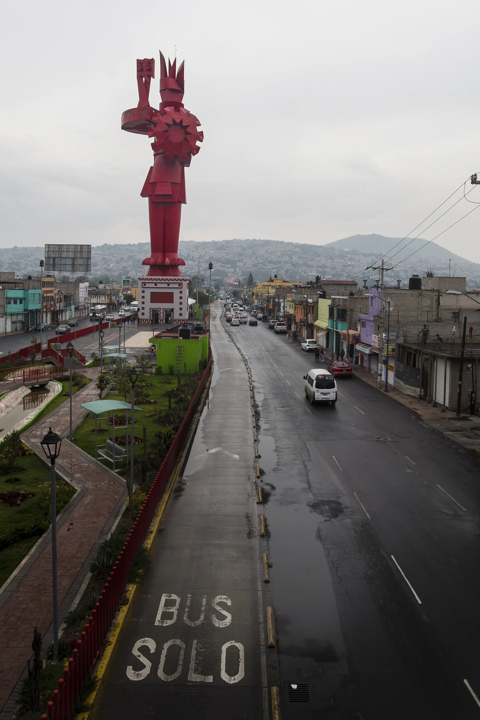
There are three things to go for. Behind the town hall is the Los Pochotes archaeological site, a hectare occupied from the Late Preclassic to the Postclassic, with a three-platform pyramid, a ballcourt and a stone serpent; the site museum shows Pleistocene fauna and the 1984 find of the "Chimalhuacán Man", about 12,000 years old. The second is the Guerrero Chimalli, a red sculpture 60 m tall and 600 tonnes by Enrique Carbajal "Sebastián", unveiled on 13 December 2014 on Avenida Bordo de Xochiaca; its base is a museum. The third is stonecarving: carvers still work, and the municipality runs a school to teach the craft.
The feasts are Santo Domingo de Guzmán on 4 August and the Virgen del Rosario on 7 October, which lasts three weeks. Separate from them are the Feria de la Piedra and the Feria de la Aceituna, held the first weekend of December on Plaza Xochiaca. At the table look for fish tamales, duck in mole, frog legs in green sauce, ahuautle and pulque.
How to get to Santa María Chimalhuacán
Drive from Mexico City: 30 min, 26 km
By car: from Mexico City follow Calzada Ignacio Zaragoza and then the federal Mexico–Texcoco highway to the Chimalhuacán exit, as INAH directs for the archaeological site, which is behind the town hall (Calle Pochotes s/n, San Andrés neighbourhood). Central Chimalhuacán is about 19 km in a straight line from the Zócalo, roughly 45 minutes or more in traffic.
By public transport: the most direct is Mexibús Line 3, which leaves the Pantitlán terminal (connecting with the Metro) and ends in Chimalhuacán; stops include Acuitlapilco, Los Patos, Canteros, Las Flores, Guerrero Chimalli and Las Torres. There are three services: ordinary (45 to 60 min), Express-1 (30 to 45) and Express-2 (25 to 35). Buses of the México–Los Reyes–Chimalhuacán line also run from the Zaragoza terminal, plus microbuses and mototaxis within the municipality. Teotihuacán, the nearest pueblo, is about 31 km as the crow flies, roughly an hour by car.
Directions to Santa María Chimalhuacán on Google Maps
Distances are in a straight line; the road is usually longer.
Links open a partner site. We may earn a commission if you book, at no cost to you.
From the nearest cities to Santa María Chimalhuacán
- Mexico City · 26 km by road, 30 min
- San Martín Texmelucan · 89 km by road, 1 h 15 min
- Toluca · 86 km by road, 1 h 25 min
Drive times by road from OpenStreetMap, without traffic or stops. Times marked ~ are estimated from the straight-line distance.
Before you go to Santa María Chimalhuacán: hours, prices and tips
- Hours
- Museo de Sitio de Chimalhuacán: Tuesday to Sunday, 10:00 to 17:00. INAH, Sistema de Información Cultural · checked Oct 2026
- Entry
- Free entry to the site museum. INAH, Sistema de Información Cultural · checked Oct 2026
- Best time of day
- Santo Domingo de Guzmán is celebrated on 4 August and the Virgen del Rosario on 7 October, with festivities lasting about three weeks. Wikipedia (es): Municipio de Chimalhuacán · checked Oct 2026
- Rules
- No food, smoking, pets or flash; professional cameras pay an extra fee. INAH, Sistema de Información Cultural · checked Oct 2026
Hours and prices change, especially around holidays. Each fact links to where we checked it.
Visiting Santa María Chimalhuacán: what to see and do
The Los Pochotes archaeological site and its site museum, behind the town hall.
The Guerrero Chimalli, a 60 m red sculpture on Avenida Bordo de Xochiaca with a museum in its base.
The church of Santo Domingo de Guzmán, in cantera stone, in the centre.
The stonecarving workshops and the carvers' school.
The feasts of Santo Domingo (4 August) and the Virgen del Rosario (7 October).
The Feria de la Aceituna, the first weekend of December on Plaza Xochiaca.
Plan your trip
Places to stay in Santa María Chimalhuacán
Compare hotels, posadas, and rentals in and around Santa María Chimalhuacán.
Tours & activities
Day trips and guided outings from Teotihuacán often include Santa María Chimalhuacán; with a local guide you can get there without a car.
Rental cars
Pick up a car at NLU (Mexico City (Felipe Ángeles)): about 35 min by road to Teotihuacán, then 31 km more to Santa María Chimalhuacán, on your own schedule.
Flights
The nearest airport with scheduled flights is Mexico City (Felipe Ángeles) (NLU), about 35 min by road from Teotihuacán, the base for Santa María Chimalhuacán.
Mobile data
Signal can drop away from Teotihuacán: download a map of the way to Santa María Chimalhuacán before you set out, or carry an eSIM with data.
Links open a partner site. We may earn a commission if you book, at no cost to you.
When to go to Santa María Chimalhuacán mild
Santa María Chimalhuacán shares the climate of Teotihuacán, 31 km away. The best months to visit are January, February, March, and December.
See the month-by-month climate of Teotihuacán
Weather in Santa María Chimalhuacán now and the next 7 days
Live forecast from Open-Meteo. Chance of rain is the day's highest.
The closest Pueblo Mágico: Teotihuacán

Teotihuacán is the Pueblo Mágico closest to Santa María Chimalhuacán, with places to stay, food, and more to see.
Also close to
- Otumba · Estado de México · 36 km away
- Tepotzotlán · Estado de México · 42 km away
- Tepoztlán · Morelos · 53 km away
- Tlayacapan · Morelos · 54 km away
- Zempoala · Hidalgo · 61 km away
Closest to Santa María Chimalhuacán
-
Montecillo · Village · 5 km away
-
Chicoloapan de Juárez · City · 6 km away
-
Santiago Cuautlalpan · Town · 6 km away
-
Ciudad Nezahualcóyotl · City · 8 km away
-
Capilla Riveriana de Chapingo · Landmark · 9 km away
-
Los Reyes Acaquilpan · Town · 9 km away
-
San Miguel Coatlinchán · Town · 9 km away
-
San Luis Huexotla · Town · 10 km away


Near Santa María Chimalhuacán


Drive times by road from OpenStreetMap, without traffic. Times marked ~ are estimated from the straight-line distance.
Location from OpenStreetMap. Written by Puebloteca.