Town La Paz, Estado de México Valley of Mexico
Seat of La Paz at the end of Metro Line A: an 18th-century Santos Reyes church, a pre-Hispanic pyramid and a big feast on 6 January.
From Mexico City: 25 min by car (22 km by road) How to get there ↓
Near here
See everything nearby ↓


Plan your visit to Los Reyes Acaquilpan
Where to stay near Los Reyes Acaquilpan
Compare hotels, posadas and guest houses in Los Reyes Acaquilpan.
Tours to Los Reyes Acaquilpan
Day trips around Teotihuacán sometimes stop in Los Reyes Acaquilpan; a tour is the easy way to see it without a car.
 Tours from Mexico City
Teotihuacan pyramids morning or afternoon without tourist traps
★ 4.9 (10,269) · From US$59
How to get to Los Reyes Acaquilpan
- From Mexico City: about 25 min by road (~22 km)
- Nearest airport: Mexico City (Felipe Ángeles) (NLU), 35 min by car to Teotihuacán
Links open a partner site. We may earn a commission if you book, at no cost to you.
Tours from Mexico City, near Los Reyes Acaquilpan


Tours, prices and ratings from Viator, checked weekly. We may earn a commission if you book.
About Los Reyes Acaquilpan
Los Reyes Acaquilpan, which nearly everyone calls Los Reyes or Los Reyes La Paz, is the seat of the municipality of La Paz in the east of the State of Mexico, right against Iztapalapa. INEGI counted 84,298 people in 2020. It sits at about 2,250 m on the slopes of the Santa Catarina volcano, southeast of the former Lake Texcoco. Acaquilpan translates as "above the reeds with quelites". Do not confuse it with Los Reyes Coyoacán, a different town that did belong to the Marquesado del Valle.
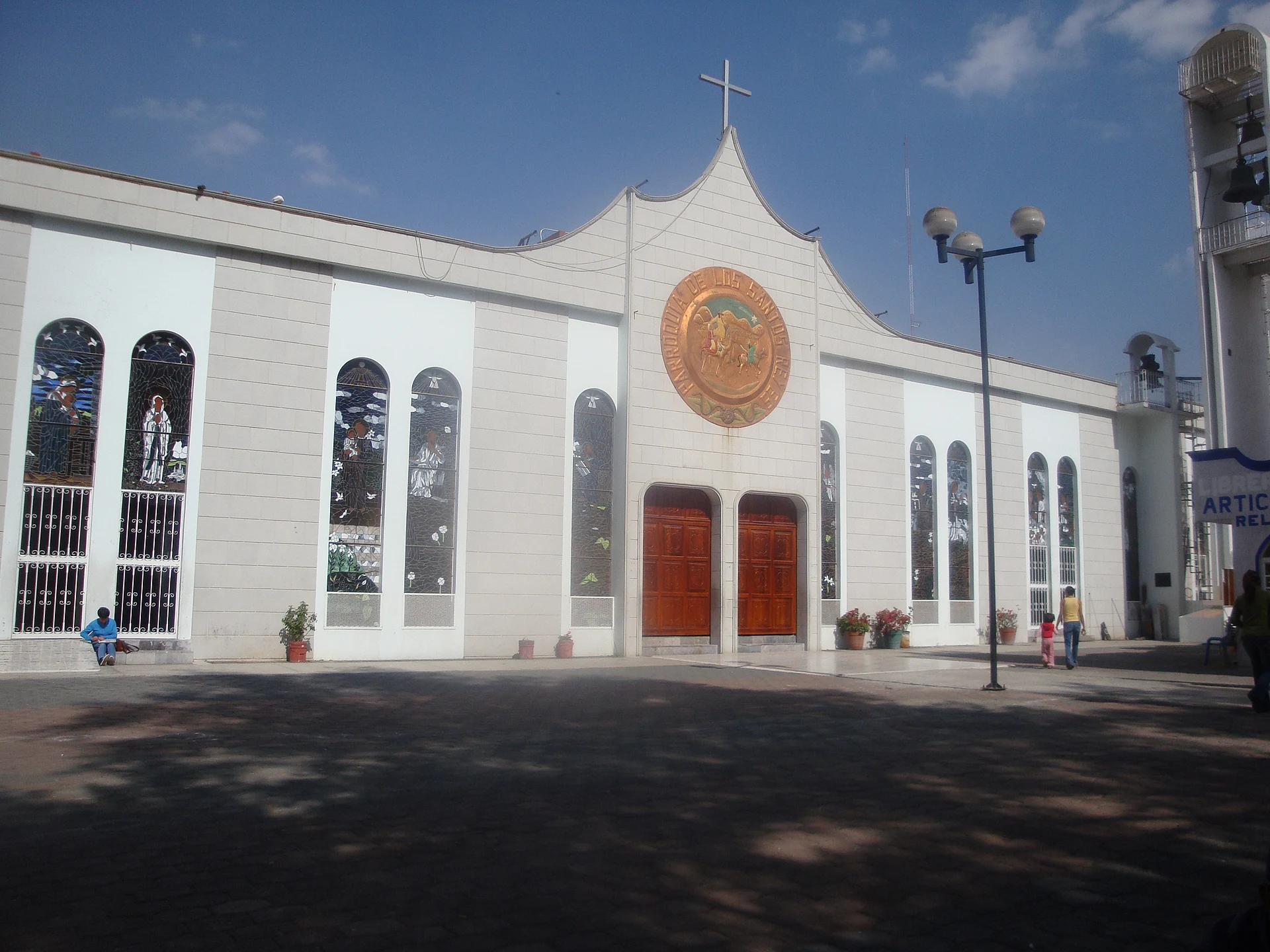
The history is long. The place began as a Coyotlatelco-phase settlement; the Pirámide de Los Reyes archaeological zone, with a main pyramid facing west and a small group of rooms, was discovered in the early 1970s. In the 18th century the Templo de los Santos Reyes went up, and it keeps its original doorway, coat of arms and niche; in 1993 a new church was built next to it, the one that appears in photographs. The town joined the municipality in 1888, and since 1899 it has been called La Paz.
The moment to go is 6 January, the patron feast: fairground rides, dancing on the municipal esplanade, pyrotechnic castles and, all night, a toy market on the main street for the Three Kings. In February or March a four-day carnival brings charros carnavaleros and escaramuzas. Outside those dates it is a commercial and industrial city with no tourist circuit of its own.
How to get to Los Reyes Acaquilpan
Drive from Mexico City: 25 min, 22 km
The easiest way is the Metro: Line A (Pantitlán-La Paz) has three stations in the municipality, Santa Marta, Los Reyes and La Paz; Los Reyes exits at Av. Puebla and Pensador Mexicano, next to the town hall, and La Paz is the eastern terminus, with a bus terminal. By car, the Calzada Ignacio Zaragoza (the federal Mexico-Puebla road), the Mexico-Puebla toll road and Eje 8 Sur begin or end here; the Mexico-Texcoco road also starts in the municipality. It is about 18 km in a straight line from central Mexico City, and Metro time depends on connections and the hour. Teotihuacán is about 40 km away in a straight line, approx.
Directions to Los Reyes Acaquilpan on Google Maps
Distances are in a straight line; the road is usually longer.
Links open a partner site. We may earn a commission if you book, at no cost to you.
From the nearest cities to Los Reyes Acaquilpan
- Mexico City · 22 km by road, 25 min
- San Martín Texmelucan · 76 km by road, 1 h 10 min
- Cuautla · 81 km by road, 1 h 15 min
Drive times by road from OpenStreetMap, without traffic or stops. Times marked ~ are estimated from the straight-line distance.
Before you go to Los Reyes Acaquilpan: hours, prices and tips
- Best time of day
- 6 January is the day with the most going on; the rest of the year the centre is an ordinary working town. Wikipedia · checked Oct 2026
- Best season
- The patron feast is 6 January (Santos Reyes), with a toy market that runs all night; carnival falls in February or March, and Holy Week is observed in the municipality's churches in March or April. Wikipedia · checked Oct 2026
Hours and prices change, especially around holidays. Each fact links to where we checked it.
Visiting Los Reyes Acaquilpan: what to see and do
The 18th-century Templo de los Santos Reyes with its original doorway, and the new 1993 parish church beside it.
The Pirámide de Los Reyes, an archaeological zone discovered in the early 1970s.
The municipal esplanade and town hall, the stage for the 6 January feast and the "La Paz en el Mundo" cultural festival.
The 16th-century church of San Sebastián Mártir in Chimalpa, in Churrigueresque style.
The February or March carnival, with charros carnavaleros and escaramuzas.
The Casa de Cultura in the town centre, with workshops open to the public.
Plan your trip
Places to stay in Los Reyes Acaquilpan
Compare hotels, posadas, and rentals in and around Los Reyes Acaquilpan.
Tours & activities
Day trips around Teotihuacán sometimes stop in Los Reyes Acaquilpan; a tour is the easy way to see it without a car.
Rental cars
Pick up a car at NLU (Mexico City (Felipe Ángeles)): about 35 min by road to Teotihuacán, then 40 km more to Los Reyes Acaquilpan, on your own schedule.
Flights
The nearest airport with scheduled flights is Mexico City (Felipe Ángeles) (NLU), about 35 min by road from Teotihuacán, the base for Los Reyes Acaquilpan.
Mobile data
Signal can drop away from Teotihuacán: download a map of the way to Los Reyes Acaquilpan before you set out, or carry an eSIM with data.
Links open a partner site. We may earn a commission if you book, at no cost to you.
When to go to Los Reyes Acaquilpan mild
Los Reyes Acaquilpan shares the climate of Teotihuacán, 40 km away. The best months to visit are January, February, March, and December.
See the month-by-month climate of Teotihuacán
Weather in Los Reyes Acaquilpan now and the next 7 days
Live forecast from Open-Meteo. Chance of rain is the day's highest.
The closest Pueblo Mágico: Teotihuacán

Teotihuacán is the Pueblo Mágico closest to Los Reyes Acaquilpan, with places to stay, food, and more to see.
Also close to
- Otumba · Estado de México · 44 km away
- Tepoztlán · Morelos · 44 km away
- Tlayacapan · Morelos · 45 km away
- Tepotzotlán · Estado de México · 47 km away
- Huejotzingo · Puebla · 64 km away
Closest to Los Reyes Acaquilpan
-
Santiago Acahualtepec · Village · 3 km away
-
Volcán Guadalupe · Mountain · 5 km away
-
Ciudad Nezahualcóyotl · City · 6 km away
-
Santa María Chimalhuacán · City · 9 km away
-
Yuhualixqui · Mountain · 9 km away
-
Acozac · Archaeological site · 10 km away
-
Chicoloapan de Juárez · City · 10 km away
-
Lago de Chalco · Lake · 10 km away


Near Los Reyes Acaquilpan


Drive times by road from OpenStreetMap, without traffic. Times marked ~ are estimated from the straight-line distance.
Location from OpenStreetMap. Written by Puebloteca.