Town Tecalitlán, Jalisco
Home town of Mariachi Vargas, founded here in 1897; every October it hosts the Los Sones mariachi festival.
From Ciudad Guzmán: 35 min by car (43 km by road) How to get there ↓
Near here
See everything nearby ↓


Plan your visit to Tecalitlán
Where to stay near Tecalitlán
Compare hotels, posadas and guest houses in Tecalitlán.
Tours to Tecalitlán
Day trips around Comala sometimes stop in Tecalitlán; a tour is the easy way to see it without a car.
How to get to Tecalitlán
- From Ciudad Guzmán: about 35 min by road (~43 km)
- Nearest airport: Colima (CLQ), 32 min by car to Comala
Links open a partner site. We may earn a commission if you book, at no cost to you.
About Tecalitlán
Tecalitlán is the seat of the municipality of the same name, at the southern tip of Jalisco, at about 1,130 metres above sea level and some 43 km from Ciudad Guzmán. At the 2020 census the town had 13,243 inhabitants. The name is Nahuatl and is read as "next to the stone houses". The region was conquered in 1522 by Cristóbal de Olid and Juan Rodríguez de Villafuerte, sent by Cortés, and the present town was founded by Miguel Ponce de León on 6 December 1776 as Valle de Nuestra Señora de Guadalupe de Tecalitlán; it was made a pueblo in 1781.
Its fame is mariachi. Maestro Gaspar Vargas founded Mariachi Vargas de Tecalitlán here in 1897; his son Silvestre took it to win contests in Guadalajara and Mexico City, and it is now based in the capital. Since 2016 the town has held the Festival Cultural del Mariachi Los Sones in early October: the eighth edition, in 2025, ran from 2 to 12 October with eleven free galas at the Recinto Los Sones on the main square, and was a tribute to Silvestre Vargas.
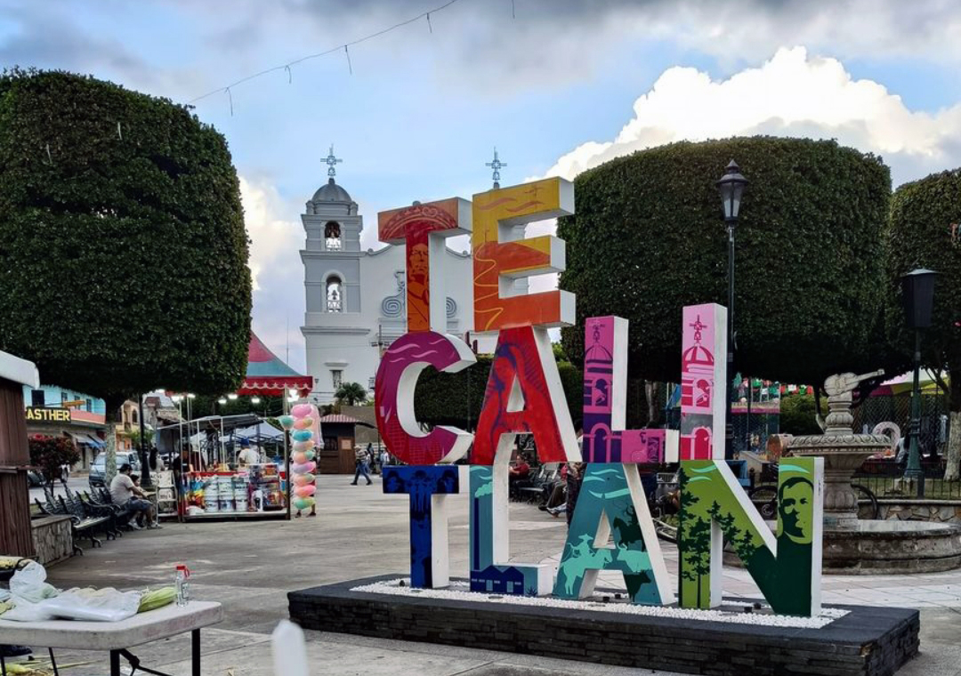
The centre is built around the garden and the parish of Nuestra Señora de Guadalupe. The Virgin is celebrated from 3 to 12 December, with the main velada on the 10th. Santa Cruz is marked on 3 May on the hill of that name, and the municipality has a lienzo charro, a bullring, a museum and several dams. Local food is birria and barbacoa. Sugar cane was once a major industry; agriculture (maize, beans, mango, peach) and livestock matter more today.
How to get to Tecalitlán
Drive from Ciudad Guzmán: 35 min, 43 km
By car, Tecalitlán is about 163 km from Guadalajara, roughly 2 hours: on the 54D Guadalajara-Colima toll road to near Ciudad Guzmán and then highway 110 (Jiquilpan-Colima). From Ciudad Guzmán, the nearest city, it is about 43 km (about 35 minutes), and from Colima about 67 km, roughly an hour.
There is no direct bus from Guadalajara. Primera Plus leaves the Nueva Central Camionera (Module 1) for Ciudad Guzmán about hourly, a trip of around 2 hours. From there Sur de Jalisco runs Ciudad Guzmán-Tecalitlán, about 46 minutes, with seven departures between 6:10 and 19:40; the same line leaves Colima with seven departures between 8:20 and 20:20, about 1 h 30 min. Buses arrive at the Terminal de autobuses Tecalitlán. Schedules can change; confirm at the ticket window.
Directions to Tecalitlán on Google Maps
Distances are in a straight line; the road is usually longer.
Links open a partner site. We may earn a commission if you book, at no cost to you.
From the nearest cities to Tecalitlán
- Ciudad Guzmán · 43 km by road, 35 min
- Colima · 71 km by road, 1 h
- Tecomán · 117 km by road, 1 h 40 min
Drive times by road from OpenStreetMap, without traffic or stops. Times marked ~ are estimated from the straight-line distance.
Before you go to Tecalitlán: hours, prices and tips
- Best season
- Los Sones mariachi festival in early October (2-12 October in 2025); Virgen de Guadalupe 3-12 December, velada on the 10th; Santa Cruz on 3 May; San Francisco on 4 October; Santa Gertrudis on 16 November. Wikipedia / Crónica Jalisco · checked Oct 2026
Hours and prices change, especially around holidays. Each fact links to where we checked it.
Visiting Tecalitlán: what to see and do
Attend the Festival Cultural del Mariachi Los Sones in early October, with free galas at the Recinto Los Sones.
Walk the garden and the parish of Nuestra Señora de Guadalupe.
Visit the municipal museum, tied to the mariachi tradition.
Climb the Cerro de la Santa Cruz, where Santa Cruz is celebrated on 3 May.
Try birria and barbacoa, dishes of the region.
Plan your trip
Places to stay in Tecalitlán
Compare hotels, posadas, and rentals in and around Tecalitlán.
Tours & activities
Day trips around Comala sometimes stop in Tecalitlán; a tour is the easy way to see it without a car.
Rental cars
Pick up a car at CLQ (Colima): about 32 min by road to Comala, then 50 km more to Tecalitlán, on your own schedule.
Flights
The nearest airport with scheduled flights is Colima (CLQ), about 32 min by road from Comala, the base for Tecalitlán.
Mobile data
Signal can drop away from Comala: download a map of the way to Tecalitlán before you set out, or carry an eSIM with data.
Links open a partner site. We may earn a commission if you book, at no cost to you.
When to go to Tecalitlán warm
Tecalitlán shares the climate of Comala, 50 km away. The best months to visit are January, February, November, and December.
See the month-by-month climate of Comala
Weather in Tecalitlán now and the next 7 days
Live forecast from Open-Meteo. Chance of rain is the day's highest.
The closest Pueblo Mágico: Comala

Comala is the Pueblo Mágico closest to Tecalitlán, with places to stay, food, and more to see.
Also close to
Closest to Tecalitlán
-
Tuxpan · Town · 12 km away
-
Zapotiltic · Town · 21 km away
-
Tamazula de Gordiano · Town · 23 km away
-
Tonila · Town · 26 km away
-
Jilotlán de los Dolores · Village · 32 km away
-
Nevado de Colima · Mountain · 33 km away
-
Volcán de Colima · Mountain · 33 km away
-
La Garita · Village · 39 km away


Near Tecalitlán


Drive times by road from OpenStreetMap, without traffic. Times marked ~ are estimated from the straight-line distance.
Location from OpenStreetMap. Written by Puebloteca.