Town Tuxpan, Jalisco
Southern Jalisco town with a 1536 Franciscan convent, the sonajeros dance and 82 patron-saint fiestas a year; cuachala is the local dish.
From Ciudad Guzmán: 25 min by car (31 km by road) How to get there ↓
Near here
See everything nearby ↓


Plan your visit to Tuxpan
Where to stay near Tuxpan
Compare hotels, posadas and guest houses in Tuxpan.
Tours to Tuxpan
Day trips around Sayula sometimes stop in Tuxpan; a tour is the easy way to see it without a car.
How to get to Tuxpan
- From Ciudad Guzmán: about 25 min by road (~31 km)
- Nearest airport: Colima (CLQ), 1 h 14 min by car to Sayula
Links open a partner site. We may earn a commission if you book, at no cost to you.
About Tuxpan
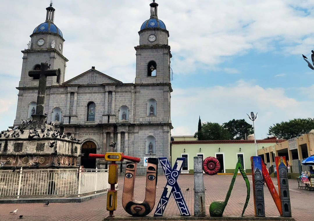
Tuxpan is the seat of the municipality of the same name in southern Jalisco, at about 1,000 metres above sea level. At the 2020 census the town had 30,471 people. The name comes from Tochpan, interpreted as "land of rabbits". Franciscan friars founded the town in 1536 with a convent dedicated to San Juan Bautista, and the eight-armed atrial cross of the parish is considered one of the oldest colonial monuments in Jalisco. An earthquake in 1941 almost destroyed the town; rebuilding of the arcades began in 1955.
Life in Tuxpan revolves around its fiestas: it is called the town of the eternal fiesta because its neighbourhoods and communities celebrate 82 patron-saint festivals, each lasting about a week. The sonajeros and xayacates dances are famous, performed in January for San Sebastián (the 20th and 27th) and on 2 February for Candelaria. In May the town honours the Señor del Perdón, protector of the town in earthquakes, along with Santa Cruz (3 May).
At the table, look for cuachala, a savoury atole with chicken, chile and tomato served in a clay bowl; frijoles güeros, a Lenten dish; and tacos de la estación, once sold to train passengers. The railway station, from 1908, still stands. The Tuxpan River, locally called Tizatirla, runs through town and has bathing spots, and Cerro Cihuapilli (1,724 m) offers rock for climbing and a chapel where Guadalupe devotees gather on 12 December.
How to get to Tuxpan
Drive from Ciudad Guzmán: 25 min, 31 km
Tuxpan is about 25 km from Ciudad Guzmán: 29 minutes by car. Omnibus de México runs a direct service from Ciudad Guzmán to Tuxpan every two hours, about 50 minutes. From Guadalajara it is about 148 km (roughly 1 h 50 min by car). By bus there are two options: Rápidos de Zapotlán, from the Antigua Central Camionera (Central Vieja) 3 times a day, about 2 h 30 min; and Omnibus de México, from the Nueva Central Camionera (module 6), every two hours, about 3 h 15 min. Omnibus de México schedules and bookings are at odm.com.mx. Buses arrive at the Tuxpan station.
Directions to Tuxpan on Google Maps
Distances are in a straight line; the road is usually longer.
Links open a partner site. We may earn a commission if you book, at no cost to you.
From the nearest cities to Tuxpan
- Ciudad Guzmán · 31 km by road, 25 min
- Colima · 60 km by road, 50 min
- Tecomán · 105 km by road, 1 h 30 min
Drive times by road from OpenStreetMap, without traffic or stops. Times marked ~ are estimated from the straight-line distance.
Before you go to Tuxpan: hours, prices and tips
- Best season
- Sonajeros and xayacates dances: 20 and 27 January (San Sebastián) and 2 February (Candelaria). May fiestas for the Señor del Perdón (in 2022, 13-23 May); Santa Cruz on 3 May; pilgrimages to Talpa in March; 12 December, Guadalupe at Cerro Cihuapilli. Wikipedia (Municipio de Tuxpan) · checked Oct 2026
Hours and prices change, especially around holidays. Each fact links to where we checked it.
Visiting Tuxpan: what to see and do
Visit the parish of San Juan Bautista and its 16th-century atrial cross, beside the convent founded in 1536.
See the former railway station, opened in 1908, and try the tacos de la estación.
Cool off at the Tizatirla river, with a park and bathing spots.
Climb Cerro Cihuapilli, with its Guadalupe chapel and rock for climbing.
Eat cuachala, the savoury chicken atole served in a clay bowl.
Come in January or February to see the sonajeros and xayacates dancers.
Plan your trip
Places to stay in Tuxpan
Compare hotels, posadas, and rentals in and around Tuxpan.
Tours & activities
Day trips around Sayula sometimes stop in Tuxpan; a tour is the easy way to see it without a car.
Rental cars
Pick up a car at CLQ (Colima): about 1 h 14 min by road to Sayula, then 43 km more to Tuxpan, on your own schedule.
Flights
The nearest airport with scheduled flights is Colima (CLQ), about 1 h 14 min by road from Sayula, the base for Tuxpan.
Mobile data
Signal can drop away from Sayula: download a map of the way to Tuxpan before you set out, or carry an eSIM with data.
Links open a partner site. We may earn a commission if you book, at no cost to you.
When to go to Tuxpan mild
Tuxpan shares the climate of Sayula, 43 km away. The best months to visit are January, March, November, and December.
See the month-by-month climate of Sayula
Weather in Tuxpan now and the next 7 days
Live forecast from Open-Meteo. Chance of rain is the day's highest.
The closest Pueblo Mágico: Sayula

Sayula is the Pueblo Mágico closest to Tuxpan, with places to stay, food, and more to see.
Also close to
Closest to Tuxpan
-
Zapotiltic · Town · 9 km away
-
Tecalitlán · Town · 12 km away
-
Tamazula de Gordiano · Town · 18 km away
-
Nevado de Colima · Mountain · 24 km away
-
Tonila · Town · 24 km away
-
Volcán de Colima · Mountain · 26 km away
-
Laguna Carrizalillos · Lake · 35 km away
-
La Garita · Village · 36 km away


Near Tuxpan


Drive times by road from OpenStreetMap, without traffic. Times marked ~ are estimated from the straight-line distance.
Location from OpenStreetMap. Written by Puebloteca.