
Town Tonila, Jalisco
Southern Jalisco seat on the Colima border, at the foot of the Volcán de Colima and Nevado, titled 'Valiente y Fiel Pueblo' since 1824.
From Colima: 25 min by car (30 km by road) How to get there ↓
Near here
See everything nearby ↓


Plan your visit to Tonila
Where to stay near Tonila
Compare hotels, posadas and guest houses in Tonila.
Tours to Tonila
Day trips around Comala sometimes stop in Tonila; a tour is the easy way to see it without a car.
How to get to Tonila
- From Colima: about 25 min by road (~30 km)
- Nearest airport: Colima (CLQ), 32 min by car to Comala
Links open a partner site. We may earn a commission if you book, at no cost to you.
About Tonila
Tonila is the seat of the municipality of the same name in southern Jalisco, at 1,211 metres above sea level and very close to the Colima border. Its name comes from the Nahuatl Toníllan, "heated place" or "where the sun is born". It was a Tlahuica town depending on the Zapotitlán chiefdom, conquered in October 1524; it received a town council in 1846, the title of villa in 1878 and became a Jalisco municipality in 1929. Since 1824 it has carried the title "Valiente y Fiel Pueblo de Tonila" for defending federalism, and in 1863 Benito Juárez spent a night here when the telegraph line was inaugurated. It had 3,226 inhabitants in 2020.
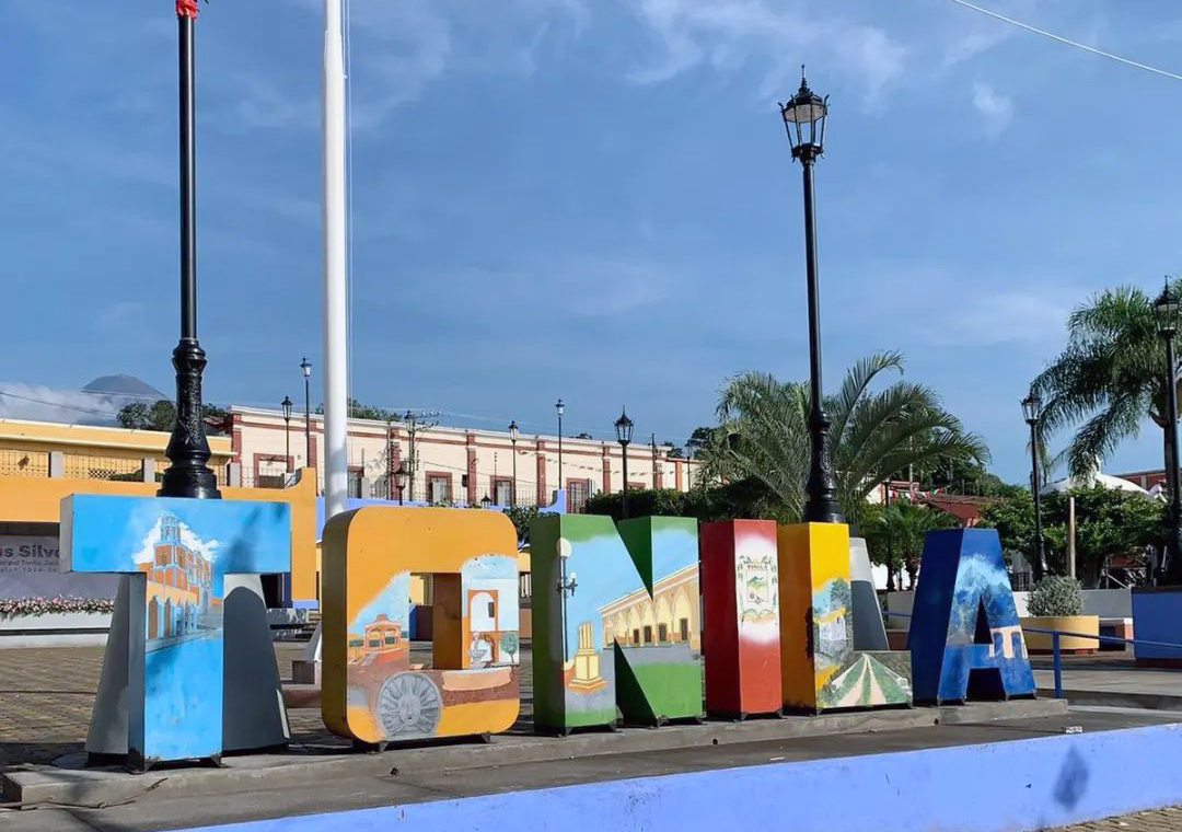
The main plaza is colourful, with gardens, palms, arcades and a lettered sign with the town's name, and the cone of the volcano shows over the rooftops. The municipality climbs from 560 to 4,260 metres and shares the Nevado de Colima and Volcán de Colima slopes; it also has the La Esperanza reservoir, the Puente de los Juanes and a replica of Chapultepec Castle. Maize, beans, sugarcane and coffee are grown.
The festive calendar runs San Marcos in April, María Auxiliadora in May, the national holiday on 15–16 September, San Martín de Porres between October and November, and the Virgin of Guadalupe in December.
How to get to Tonila
Drive from Colima: 25 min, 30 km
Tonila is in southern Jalisco and borders Zapotlán el Grande (Ciudad Guzmán), Tuxpan and Zapotitlán de Vadillo, as well as the state of Colima. The Guadalajara–Ciudad Guzmán highway passes through the municipality, and a state road runs between Tonila and Ciudad Guzmán; rural roads link the other localities. The nearest city is Colima, about 26 km away, roughly 30 minutes, and the nearest Pueblo Mágico is Comala, about 24 km, roughly 30 minutes. From Ciudad Guzmán several bus lines run to Colima, including Sur de Jalisco, Autovías, Elite and Futura; there are no published schedules for direct transport to Tonila's plaza.
Directions to Tonila on Google Maps
Distances are in a straight line; the road is usually longer.
Links open a partner site. We may earn a commission if you book, at no cost to you.
From the nearest cities to Tonila
- Colima · 30 km by road, 25 min
- Ciudad Guzmán · 48 km by road, 35 min
- Tecomán · 76 km by road, 1 h 10 min
Drive times by road from OpenStreetMap, without traffic or stops. Times marked ~ are estimated from the straight-line distance.
Before you go to Tonila: hours, prices and tips
- Best season
- San Marcos in April; María Auxiliadora in May; national holiday 15–16 September; San Martín de Porres October–November; Virgin of Guadalupe in December. Wikipedia (Municipio de Tonila) · checked Oct 2026
Hours and prices change, especially around holidays. Each fact links to where we checked it.
Visiting Tonila: what to see and do
Main plaza with the town sign, arcades and view of the volcano
Volcán de Colima and Nevado de Colima, within the municipality
La Esperanza reservoir
Puente de los Juanes
Replica of Chapultepec Castle
Plan your trip
Places to stay in Tonila
Compare hotels, posadas, and rentals in and around Tonila.
Tours & activities
Day trips around Comala sometimes stop in Tonila; a tour is the easy way to see it without a car.
Rental cars
Pick up a car at CLQ (Colima): about 32 min by road to Comala, then 24 km more to Tonila, on your own schedule.
Flights
The nearest airport with scheduled flights is Colima (CLQ), about 32 min by road from Comala, the base for Tonila.
Mobile data
Signal can drop away from Comala: download a map of the way to Tonila before you set out, or carry an eSIM with data.
Links open a partner site. We may earn a commission if you book, at no cost to you.
When to go to Tonila warm
Tonila shares the climate of Comala, 24 km away. The best months to visit are January, February, November, and December.
See the month-by-month climate of Comala
Weather in Tonila now and the next 7 days
Live forecast from Open-Meteo. Chance of rain is the day's highest.
The closest Pueblo Mágico: Comala

Comala is the Pueblo Mágico closest to Tonila, with places to stay, food, and more to see.
Also close to
Closest to Tonila
-
Laguna Carrizalillos · Lake · 13 km away
-
Volcán de Colima · Mountain · 13 km away
-
Suchitlán · Town · 17 km away
-
Laguna La María · Lake · 18 km away
-
Nevado de Colima · Mountain · 18 km away
-
Zona Arqueológica El Chanal · Archaeological site · 21 km away
-
Nogueras · Town · 22 km away
-
Tuxpan · Town · 24 km away


Near Tonila




Drive times by road from OpenStreetMap, without traffic. Times marked ~ are estimated from the straight-line distance.
Location from OpenStreetMap. Written by Puebloteca.