Village Tuxcacuesco, Jalisco
Municipal seat in the Sierra de Amula at 721 m, with an old convent, a June fiesta for San Antonio and a saddlery tradition.
From Ciudad Guzmán: 1 h 15 min by car (73 km by road) How to get there ↓
Near here
See everything nearby ↓


Plan your visit to Tuxcacuesco
Where to stay near Tuxcacuesco
Compare hotels, posadas and guest houses in Tuxcacuesco.
Tours to Tuxcacuesco
Day trips and guided outings from Tapalpa often include Tuxcacuesco; with a local guide you can get there without a car.
How to get to Tuxcacuesco
- From Ciudad Guzmán: about 1 h 15 min by road (~73 km)
- Nearest airport: Colima (CLQ), 2 h by car to Tapalpa
Links open a partner site. We may earn a commission if you book, at no cost to you.
About Tuxcacuesco
Tuxcacuesco is the seat of the municipality of the same name, in the Sierra de Amula region of southwestern Jalisco. The town sits at about 721 metres above sea level and had 1,674 inhabitants at the 2020 census; the whole municipality had 5,482. The name comes from the Nahuatl Tascahuescomatl, which the municipal encyclopedia translates as "pooled granary".
Before the Spanish arrived the area was home to Otomi-speaking warriors who often fought the people of Autlán, under a chief called Yoteacte. In 1542 Francisco Cortés de San Buenaventura came through and took the submission of the local leaders. By the end of the 16th century Tuxcacuesco was one of the four seats of the Province of Amula, where the native communities paid tribute to the Crown, and by decree of 27 March 1824 it became the seat of a department and was given the title of villa. In the municipality, at the hamlet of Apulco, the novelist Juan Rulfo was born in 1917.
What there is to visit includes the town church and former convent, the haciendas of Apulco and Zenzontla, and the church of Apulco. Out toward the hills are the Sierra de Manantlán, Cerro Piedra Ancha and the springs of La Pichintota and La Providencia. The town is also home to the Tuxca Corona distillery, founded by the Corona family, which makes an agave spirit. Local trades include saddlery, huaraches and saddle-making.
The main fiestas are San Antonio de Padua, 1 to 13 June, and the Virgen de Guadalupe, 1 to 12 December; during Easter week there is a bullfighting fair.
How to get to Tuxcacuesco
Drive from Ciudad Guzmán: 1 h 15 min, 73 km
Tuxcacuesco is in the Sierra de Amula and borders Autlán de Navarro, El Grullo, Tolimán, San Gabriel, Tonaya, El Limón and Cuautitlán de García Barragán. From Autlán it is about 35 km by road, roughly 30 minutes by car or taxi; Autlán has a taxi stand (Sitio Paulino Navarro). There are no published bus schedules for this stretch, so driving is the practical option, or ask at the Autlán terminal about buses or colectivos to Tuxcacuesco. Once in town everything is walkable.
Directions to Tuxcacuesco on Google Maps
Distances are in a straight line; the road is usually longer.
Links open a partner site. We may earn a commission if you book, at no cost to you.
From the nearest cities to Tuxcacuesco
- Ciudad Guzmán · 73 km by road, 1 h 15 min
- Autlán · 74 km by road, 1 h 20 min
- Colima · 95 km by road, 2 h 5 min
Drive times by road from OpenStreetMap, without traffic or stops. Times marked ~ are estimated from the straight-line distance.
Before you go to Tuxcacuesco: hours, prices and tips
- Best season
- Fiesta of San Antonio de Padua 1-13 June; Virgen de Guadalupe 1-12 December; bullfighting fair in Easter week. Wikipedia: Municipio de Tuxcacuesco · checked Oct 2026
Hours and prices change, especially around holidays. Each fact links to where we checked it.
Visiting Tuxcacuesco: what to see and do
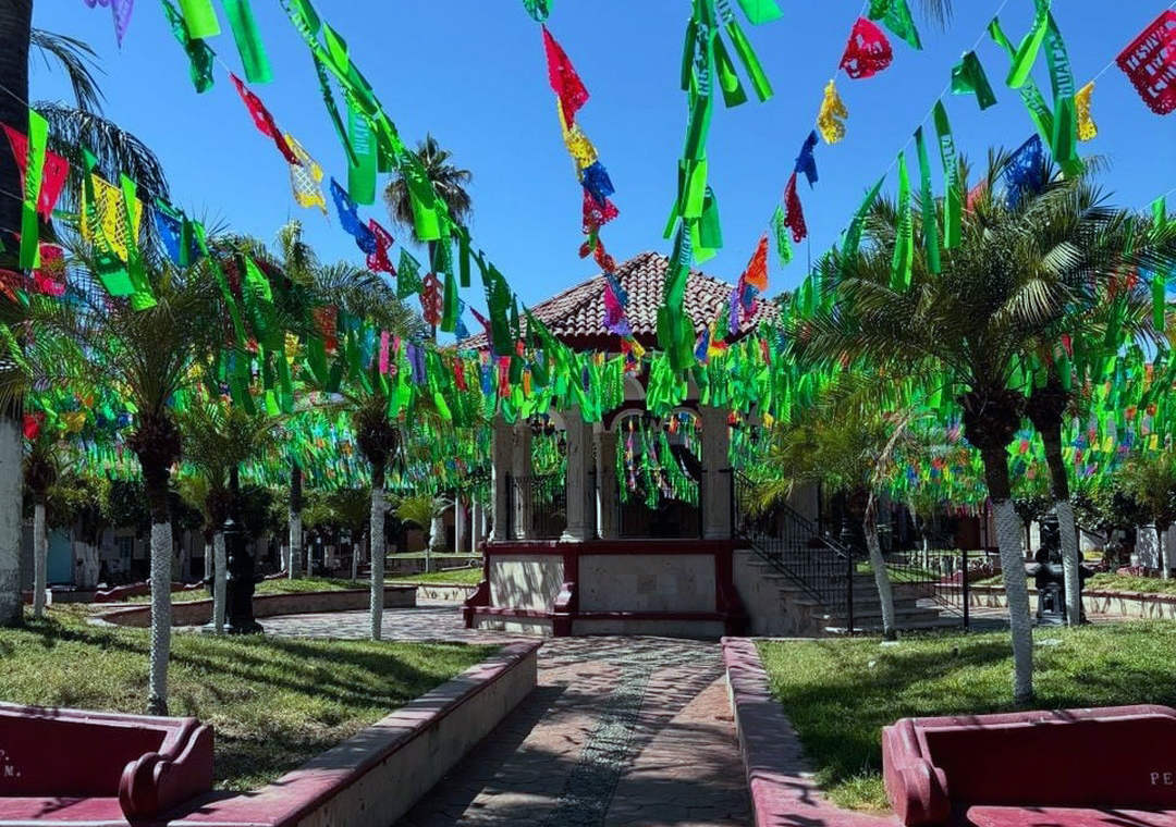
The main plaza and its bandstand
The church and former convent of Tuxcacuesco
The haciendas of Apulco and Zenzontla
The springs of La Pichintota and La Providencia
The fiesta of San Antonio de Padua, 1 to 13 June
Plan your trip
Places to stay in Tuxcacuesco
Compare hotels, posadas, and rentals in and around Tuxcacuesco.
Tours & activities
Day trips and guided outings from Tapalpa often include Tuxcacuesco; with a local guide you can get there without a car.
Rental cars
Pick up a car at CLQ (Colima): about 2 h by road to Tapalpa, then 36 km more to Tuxcacuesco, on your own schedule.
Flights
The nearest airport with scheduled flights is Colima (CLQ), about 2 h by road from Tapalpa, the base for Tuxcacuesco.
Mobile data
Signal can drop away from Tapalpa: download a map of the way to Tuxcacuesco before you set out, or carry an eSIM with data.
Links open a partner site. We may earn a commission if you book, at no cost to you.
When to go to Tuxcacuesco mild
Tuxcacuesco shares the climate of Tapalpa, 36 km away. The best months to visit are January, March, April, and November.
See the month-by-month climate of Tapalpa
Weather in Tuxcacuesco now and the next 7 days
Live forecast from Open-Meteo. Chance of rain is the day's highest.
The closest Pueblo Mágico: Tapalpa

Tapalpa is the Pueblo Mágico closest to Tuxcacuesco, with places to stay, food, and more to see.
Also close to
Closest to Tuxcacuesco
-
Tolimán · Town · 13 km away
-
El Limón · Town · 23 km away
-
San Gabriel · Town · 23 km away
-
Copala · Village · 24 km away
-
Zapotitlán de Vadillo · Village · 25 km away
-
El Grullo · Town · 27 km away
-
Salto del Nogal · Waterfall · 29 km away
-
Ejutla · Town · 30 km away


Near Tuxcacuesco




Drive times by road from OpenStreetMap, without traffic. Times marked ~ are estimated from the straight-line distance.
Location from OpenStreetMap. Written by Puebloteca.