
Village Zapotitlán de Vadillo, Jalisco Colima and its volcanoes
Seat of a southern Jalisco municipality at 1,127 m, close to Colima; named for the sapote tree, with festivals in January, March and July.
From Ciudad Guzmán: 1 h 5 min by car (66 km by road) How to get there ↓
Near here
See everything nearby ↓


Plan your visit to Zapotitlán de Vadillo
Where to stay near Zapotitlán de Vadillo
Compare hotels, posadas and guest houses in Zapotitlán de Vadillo.
Tours to Zapotitlán de Vadillo
Day trips and guided outings from Comala often include Zapotitlán de Vadillo; with a local guide you can get there without a car.
 Tours from Manzanillo
Private Chichen Itza & Yaxunah Ruins with Cenote
★ 4.8 (111) · From US$518
How to get to Zapotitlán de Vadillo
- From Ciudad Guzmán: about 1 h 5 min by road (~66 km)
- Nearest airport: Colima (CLQ), 32 min by car to Comala
Links open a partner site. We may earn a commission if you book, at no cost to you.
Tours from Manzanillo, near Zapotitlán de Vadillo


Tours, prices and ratings from Viator, checked weekly. We may earn a commission if you book.
About Zapotitlán de Vadillo
Zapotitlán de Vadillo is the seat of a municipality in the Sur region of Jalisco, right against the Colima state line, at roughly 1,127 metres above sea level. At the 2020 census it had 4,214 people, more than half of the municipality's 7,466. The name comes from Nahuatl tzapotl, sapote, and titlán, place; the state statistics institute's municipal profile says it was given almost as an irony, since neighbouring Cópala is full of black sapote trees while the original site had a single lonely one.
Local tradition says the town was founded in the year 542 by a small group of Toltecs fleeing wars, and that before the conquest the region was the large kingdom of Amollan. The Spanish arrived in 1525 and, in the same account, Hernán Cortés stayed in a house built specially for him. An earthquake in 1535 wrecked the first temple, and the eruption of the volcano in 1576 shifted the settlement again; fray Juan Leandro moved it to its present site, then a small ranch of three huts. Fray Diego de la Torre finished and blessed the parish church in 1579. In 1968 a decree added "de Vadillo" to the name, honouring the politician, educator and governor Basilio Vadillo.
The municipality's listed crafts include huaraches, drawn-thread embroidery (deshilado), papier-mâché and weaving in otate cane and palm. Four protected natural areas, including the Nevado de Colima, cover 26.8% of the municipal territory, and the town has the El Cristo park.
How to get to Zapotitlán de Vadillo
Drive from Ciudad Guzmán: 1 h 5 min, 66 km
Zapotitlán de Vadillo sits at the southern tip of Jalisco, next to the Colima state line. The city of Colima is about 40 minutes away by car (approx.), and Comala, in Colima, is about 38 km and 38 minutes according to Pueblos América. The state statistics institute counts only 37.8 km of highway and 131.9 km of local roads in the whole municipality, with low connectivity, so allow extra time on secondary stretches, especially in the rainy season when visitors report flooding. There are no published bus schedules to the town; most people arrive by car from Colima, or ask at the Colima bus terminal about services to the area.
Directions to Zapotitlán de Vadillo on Google Maps
Distances are in a straight line; the road is usually longer.
Links open a partner site. We may earn a commission if you book, at no cost to you.
From the nearest cities to Zapotitlán de Vadillo
- Ciudad Guzmán · 66 km by road, 1 h 5 min
- Colima · 68 km by road, 1 h 10 min
- Autlán · 100 km by road, 1 h 35 min
Drive times by road from OpenStreetMap, without traffic or stops. Times marked ~ are estimated from the straight-line distance.
Before you go to Zapotitlán de Vadillo: hours, prices and tips
- Best season
- Feast of San José, 10-19 March; patron Santa María Magdalena, 22 July; Virgen de Guadalupe, 1-14 January; municipal fair "la fiesta de las fiestas", 29 December-12 January. Wikipedia (Municipio de Zapotitlán de Vadillo) · checked Oct 2026
Hours and prices change, especially around holidays. Each fact links to where we checked it.
Visiting Zapotitlán de Vadillo: what to see and do
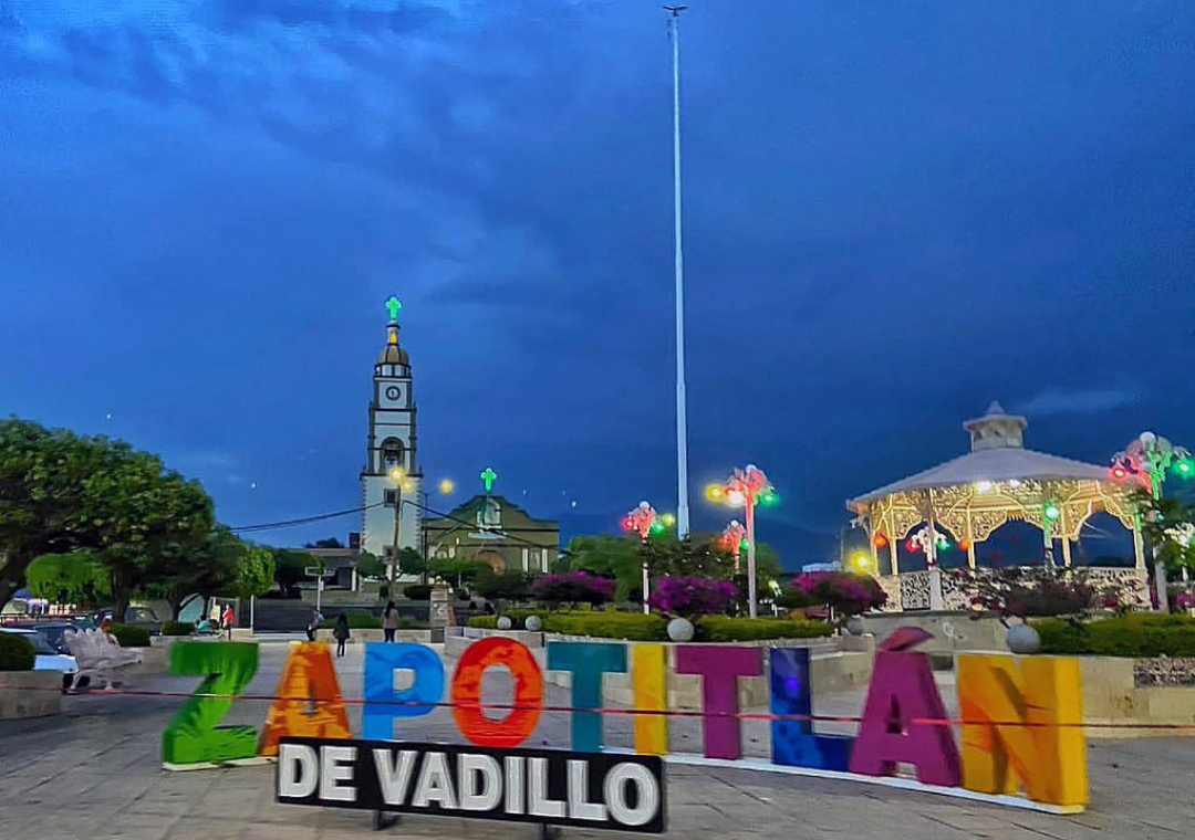
The main square, with its kiosk and the parish tower; the church was finished in 1579.
El Cristo park.
The Loma del Camichín and Piedra del Sacrificio archaeological sites in the municipality.
The petroglyphs at El Espinal.
Nevado de Colima National Park, which covers part of the municipality.
Local crafts: huaraches, deshilado and papier-mâché.
Plan your trip
Places to stay in Zapotitlán de Vadillo
Compare hotels, posadas, and rentals in and around Zapotitlán de Vadillo.
Tours & activities
Day trips and guided outings from Comala often include Zapotitlán de Vadillo; with a local guide you can get there without a car.
Rental cars
Pick up a car at CLQ (Colima): about 32 min by road to Comala, then 26 km more to Zapotitlán de Vadillo, on your own schedule.
Flights
The nearest airport with scheduled flights is Colima (CLQ), about 32 min by road from Comala, the base for Zapotitlán de Vadillo.
Mobile data
Signal can drop away from Comala: download a map of the way to Zapotitlán de Vadillo before you set out, or carry an eSIM with data.
Links open a partner site. We may earn a commission if you book, at no cost to you.
When to go to Zapotitlán de Vadillo warm
Zapotitlán de Vadillo shares the climate of Comala, 26 km away. The best months to visit are January, February, November, and December.
See the month-by-month climate of Comala
Weather in Zapotitlán de Vadillo now and the next 7 days
Live forecast from Open-Meteo. Chance of rain is the day's highest.
The closest Pueblo Mágico: Comala

Comala is the Pueblo Mágico closest to Zapotitlán de Vadillo, with places to stay, food, and more to see.
Also close to
Closest to Zapotitlán de Vadillo
-
Copala · Village · 8 km away
-
Tolimán · Town · 12 km away
-
Laguna La María · Lake · 14 km away
-
Laguna Carrizalillos · Lake · 21 km away
-
Volcán de Colima · Mountain · 21 km away
-
Zacualpan · Town · 21 km away
-
Nevado de Colima · Mountain · 22 km away
-
Suchitlán · Town · 22 km away


Near Zapotitlán de Vadillo


Drive times by road from OpenStreetMap, without traffic. Times marked ~ are estimated from the straight-line distance.
Location from OpenStreetMap. Written by Puebloteca.