

Landmark Monterrey, Nuevo León Municipality of Monterrey Monterrey and its mountains
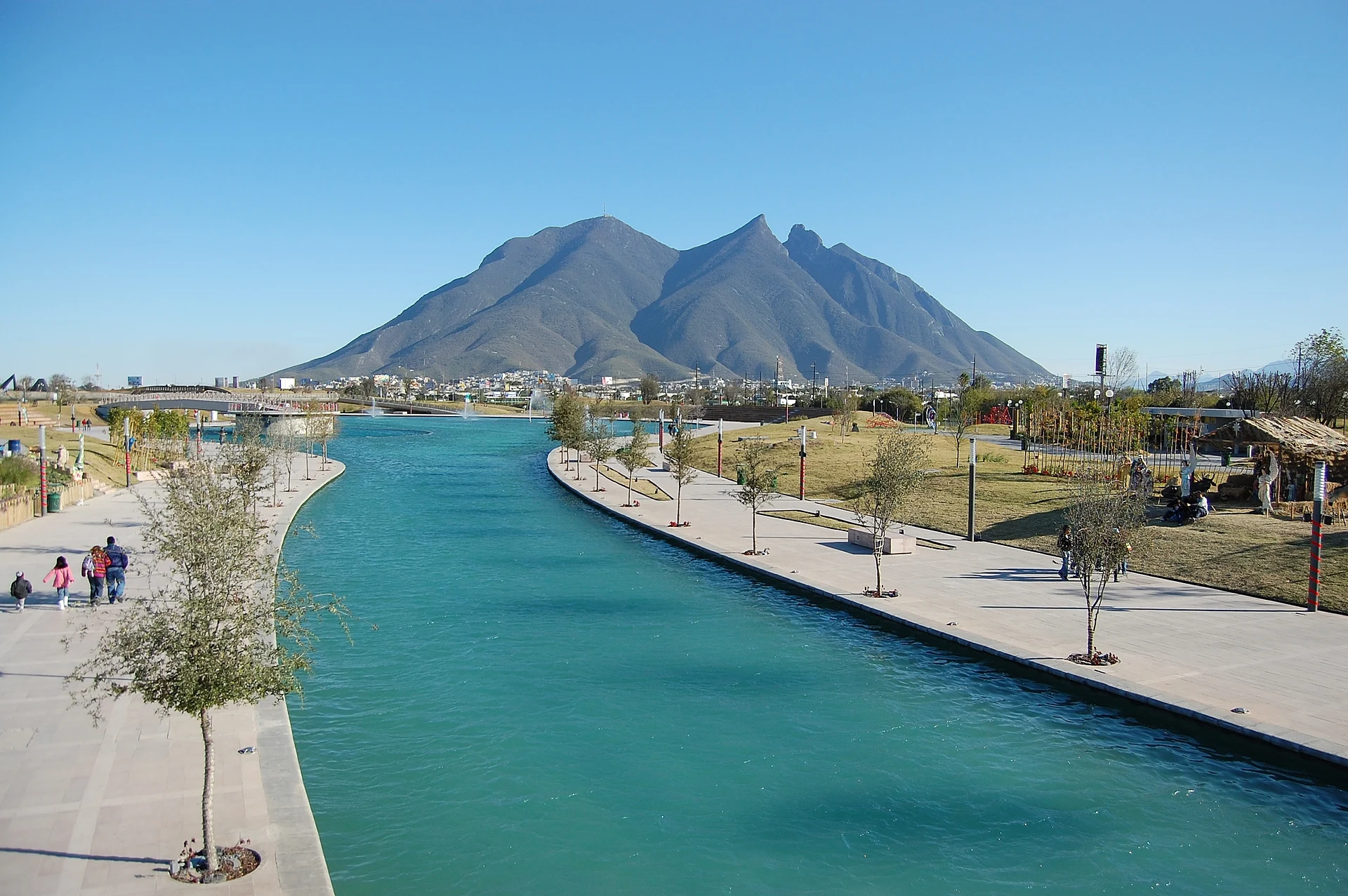
A 2.5 km artificial river through downtown Monterrey, with paths, fountains and guided boat rides from the Macroplaza museums to Parque Fundidora.
From Montemorelos: 1 h 5 min by car (80 km by road) How to get there ↓
Near here
See everything nearby ↓


Plan your visit to Paseo Santa Lucía
Where to stay near Paseo Santa Lucía
Compare hotels, posadas and guest houses in Paseo Santa Lucía.
Tours to Paseo Santa Lucía
Look for tours of the area around Santiago that stop at Paseo Santa Lucía.
 Discover Monterrey: A Self-Guided Tour
From US$4
How to get to Paseo Santa Lucía
- From Montemorelos: about 1 h 5 min by road (~80 km)
- Nearest airport: Monterrey (MTY), 44 min by car to Santiago
Links open a partner site. We may earn a commission if you book, at no cost to you.
Popular tours to Paseo Santa Lucía
Tours, prices and ratings from Viator, checked weekly. We may earn a commission if you book.
About Paseo Santa Lucía
The Paseo Santa Lucía is a 2.5 km artificial river and promenade that runs east through central Monterrey, from the Explanada Santa Lucía beside the Macroplaza to the grounds of Parque Fundidora. It is billed as the longest artificial river in Latin America. The canal is about 1.2 meters deep and lined on both banks with walkways, gardens, bridges and 24 fountains, and for most of the way the Cerro de la Silla rises ahead of you on the skyline.
The route is more than decoration. It partly follows the course of the Ojos de Santa Lucía, the springs beside which Diego de Montemayor made the third and lasting founding of Monterrey on September 20, 1596. Those springs now run underground and still feed part of the canal. The walk was built for the Fórum Internacional de las Culturas held in Monterrey in 2007 and was inaugurated on September 15 of that year by President Felipe Calderón and Governor José Natividad González Parás. Along the way, 17 plaques tell bits of local history, and a small plaza marks the site of the Battle of Monterrey of 1846.
At the starting point, in front of the Museo de Historia Mexicana and the Museo del Noreste, is La Lagartera, a relief by the Oaxacan artist Francisco Toledo made in 2008 from fiberglass, resin and sand. Farther on you pass an Inuit inukshuk called Hombre de Piedra, a gift from the Canadian government in 2007, a walkway under jets of water, and, near Fundidora, a fountain lit to look like molten iron. Boats carrying up to 40 people run the length of the canal with a guide, a trip of about 55 minutes each way according to a 2025 report; the boarding point is on the lower level by the Museo de Historia Mexicana. Walking the whole thing is easy and free, and in the evening the lights on the water make it one of the most pleasant walks downtown.
How to get to Paseo Santa Lucía
Drive from Montemorelos: 1 h 5 min, 80 km
The west end is on Calle Dr. Coss, on the east side of the Macroplaza in downtown Monterrey; the nearest Metrorrey station is Zaragoza. The east end is inside Parque Fundidora, which has its own Metrorrey station. Boats leave from the lower level by the Museo de Historia Mexicana.
Directions to Paseo Santa Lucía on Google Maps
Distances are in a straight line; the road is usually longer.
Links open a partner site. We may earn a commission if you book, at no cost to you.
From the nearest cities to Paseo Santa Lucía
- Montemorelos · 80 km by road, 1 h 5 min
- Saltillo · 92 km by road, 1 h 10 min
- Linares · 128 km by road, 1 h 45 min
Drive times by road from OpenStreetMap, without traffic or stops. Times marked ~ are estimated from the straight-line distance.
Before you go to Paseo Santa Lucía: hours, prices and tips
- Hours
- Boats run daily about 10:00–21:00. Posta (June 2025) · checked Oct 2026
- Entry
- Walking is free. Boat ride about MX$120 for adults, MX$60 for children 8–12 and INAPAM seniors, free under 7 (2025 prices). Posta (June 2025) · checked Oct 2026
- Time needed
- About 55 minutes by boat one way; allow about an hour to walk the 2.5 km with stops. Posta (June 2025) · checked Oct 2026
Hours and prices change, especially around holidays. Each fact links to where we checked it.
Visiting Paseo Santa Lucía: what to see and do
Take the guided boat ride from the Museo de Historia Mexicana to Parque Fundidora.
See Francisco Toledo's La Lagartera relief at the start of the canal.
Walk the full 2.5 km on foot, with the Cerro de la Silla ahead.
Find the plaza and plaques marking the 1846 Battle of Monterrey.
Come back after dark, when the fountains and paths are lit.
Plan your trip
Places to stay in Paseo Santa Lucía
Compare hotels, posadas, and rentals in and around Paseo Santa Lucía.
Tours & activities
Look for tours of the area around Santiago that stop at Paseo Santa Lucía.
Rental cars
Pick up a car at MTY (Monterrey): about 44 min by road to Santiago, then 31 km more to Paseo Santa Lucía, on your own schedule.
Flights
The nearest airport with scheduled flights is Monterrey (MTY), about 44 min by road from Santiago, the base for Paseo Santa Lucía.
Mobile data
Signal can drop away from Santiago: download a map of the way to Paseo Santa Lucía before you set out, or carry an eSIM with data.
Links open a partner site. We may earn a commission if you book, at no cost to you.
Photos
When to go to Paseo Santa Lucía mild
Paseo Santa Lucía shares the climate of Santiago, 31 km away. The best months to visit are January, February, March, and December.
See the month-by-month climate of Santiago
Weather in Paseo Santa Lucía now and the next 7 days
Live forecast from Open-Meteo. Chance of rain is the day's highest.
The closest Pueblo Mágico: Santiago

Santiago is the Pueblo Mágico closest to Paseo Santa Lucía, with places to stay, food, and more to see.
Also close to
- Arteaga · Coahuila · 61 km away
- General Terán · Nuevo León · 78 km away
Closest to Paseo Santa Lucía
-
Barrio Antiguo · Landmark · 1 km away
-
Macroplaza · Landmark · 1 km away
-
Monterrey · City · 1 km away
-
Parque Fundidora · Landmark · 1 km away
-
El Obispado · Landmark · 4 km away
-
Cerro del Chupón · Mountain · 7 km away
-
Cerro de la Silla · Mountain · 8 km away
-
Parque Ecológico Chipinque · Nature reserve · 9 km away


Near Paseo Santa Lucía


Drive times by road from OpenStreetMap, without traffic. Times marked ~ are estimated from the straight-line distance.
Location from OpenStreetMap. Written by Puebloteca.