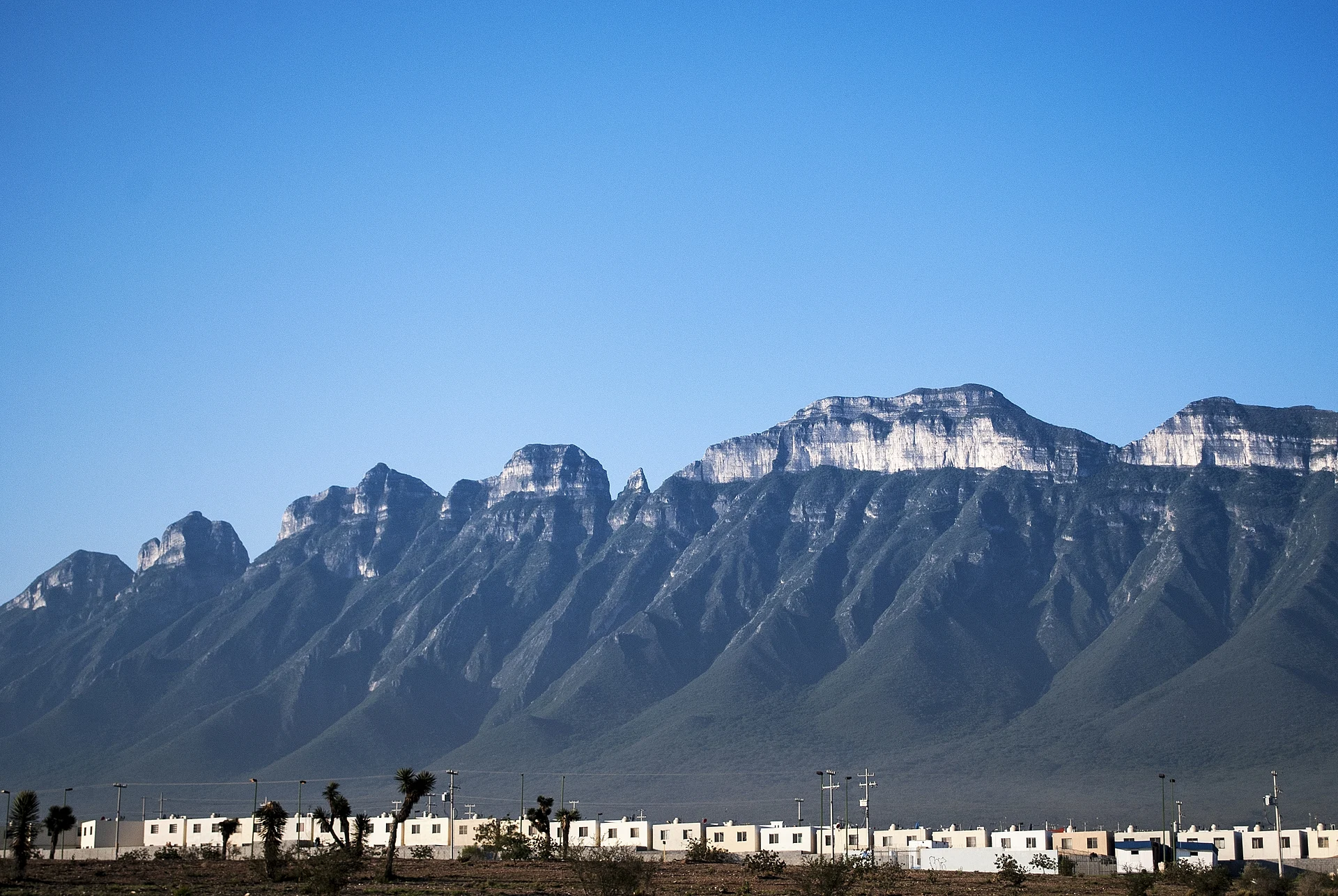


Mountain Monterrey, Nuevo León Municipality of Monterrey Monterrey and its mountains
The 21 km saw-toothed ridge on Monterrey's western skyline, topping out at about 2,060 m, with old silver mines, climbing peaks and a famous full traverse.
From Monterrey: 25 min by car (19 km by road) How to get there ↓
Near here
See everything nearby ↓


Plan your visit to Cerro de las Mitras
Where to stay near Cerro de las Mitras
Compare hotels, posadas and guest houses in Cerro de las Mitras.
Tours to Cerro de las Mitras
Day trips and guided outings from Santiago often include Cerro de las Mitras; with a local guide you can get there without a car.
 Tours from Monterrey
Matacanes : Canyoning + Hiking + Water Jumps + Rappel + Caves
★ 4.9 (1,783) · From US$157
How to get to Cerro de las Mitras
- From Monterrey: about 25 min by road (~19 km)
- Nearest airport: Monterrey (MTY), 44 min by car to Santiago
Links open a partner site. We may earn a commission if you book, at no cost to you.
Tours from Monterrey, near Cerro de las Mitras


Tours, prices and ratings from Viator, checked weekly. We may earn a commission if you book.
About Cerro de las Mitras
The Cerro de las Mitras is the long, jagged ridge that closes Monterrey's western horizon, the counterpart to the Cerro de la Silla on the east. It belongs to the Sierra Madre Oriental and runs for about 21 km from west to east, with its slopes shared by the municipalities of Monterrey, San Pedro Garza García, Santa Catarina and García. Its highest point, Pico Cuauhtémoc, is about 2,060 meters above sea level (some measurements give 2,069 m), and the mountain has a prominence of around 1,400 meters. Together with the Cerro de la Silla and the Cerro de Chipinque it makes up what locals call the trilogy of Monterrey's mountains.
The name comes from the outline of its summits, which reminded early settlers of a bishop's mitre. It is older than the city itself: the founding act of Monterrey in 1596 already mentions the Sierra de las Mitras twice, and the name is usually credited to the explorer Alberto del Canto. The mountain was also a mining district. Silver ore was found in the early 17th century, Governor Martín de Zavala inspected its mines in 1626, and lead, silver and iron were worked over the following centuries; the La Voladora mine on the north slope operated roughly from 1900 to 1918, and its owner was absorbed by the Peñoles company in 1920. Today limestone quarries cut into its flanks to supply cement and lime, a long-running source of complaints about damage to the mountain and to the city's air.
For hikers and climbers the Mitras is a serious mountain. From west to east its seven main peaks are Cuauhtémoc (about 2,069 m), Piñón (1,959 m), Pirámide (2,019 m), Perico (2,035 m), Piloto (1,953 m), Lobos (1,880 m) and Alfa, also called Apache (1,890 m); several need technical or aid climbing, while Alfa is a scramble. Other landmarks include the Siete Brujas pinnacles, the Pico del Agua and the Piquín. The path called El Nivel starts at La Voladora at about 1,570 meters and runs almost level along the north face, linking ravines through old mine tunnels, and routes such as the Ruta del Minero, Punto y Guion and the Cueva de los Cristales explore the old workings and caves. The ultimate challenge is the end-to-end traverse of the ridge: about 28 km over 15 peaks with some 3,500 meters of climbing, which the fastest recorded team has done in 10 hours 28 minutes.
How to get to Cerro de las Mitras
Drive from Monterrey: 25 min, 19 km
The ridge rises on the north-western edge of the Monterrey metropolitan area, between Monterrey, San Pedro Garza García, Santa Catarina and García, and is reached by car from any of them. The La Voladora mine area, start of El Nivel, is on the north slope at about 1,570 m. Monterrey's airport in Apodaca is about 28 km north-east of downtown.
Directions to Cerro de las Mitras on Google Maps
Distances are in a straight line; the road is usually longer.
Links open a partner site. We may earn a commission if you book, at no cost to you.
From the nearest cities to Cerro de las Mitras
- Monterrey · 19 km by road, 25 min
- Saltillo · 75 km by road, 1 h 5 min
- Montemorelos · 96 km by road, 1 h 25 min
Drive times by road from OpenStreetMap, without traffic or stops. Times marked ~ are estimated from the straight-line distance.
Visiting Cerro de las Mitras: what to see and do
Walk El Nivel from La Voladora, through old mine tunnels along the north face.
Climb Pico Alfa (Apache), the easiest of the seven main peaks.
Explore the mining routes such as the Ruta del Minero and the Cueva de los Cristales with a guide.
If you are a very experienced mountaineer, attempt the 28 km end-to-end traverse over 15 peaks.
Plan your trip
Places to stay in Cerro de las Mitras
Compare hotels, posadas, and rentals in and around Cerro de las Mitras.
Tours & activities
Day trips and guided outings from Santiago often include Cerro de las Mitras; with a local guide you can get there without a car.
Rental cars
Pick up a car at MTY (Monterrey): about 44 min by road to Santiago, then 44 km more to Cerro de las Mitras, on your own schedule.
Flights
The nearest airport with scheduled flights is Monterrey (MTY), about 44 min by road from Santiago, the base for Cerro de las Mitras.
Travel insurance
If you plan on hiking at altitude at Cerro de las Mitras, check that your policy covers it: some plans leave adventure activities out.
Mobile data
Signal can drop away from Santiago: download a map of the way to Cerro de las Mitras before you set out, or carry an eSIM with data.
Links open a partner site. We may earn a commission if you book, at no cost to you.
Photos
When to go to Cerro de las Mitras mild
Cerro de las Mitras shares the climate of Santiago, 44 km away. The best months to visit are January, February, March, and December.
For the clearest views from Cerro de las Mitras, go in the driest months (January, February, August, and December); in the rains, clouds tend to build up by midday.
See the month-by-month climate of Santiago
Weather in Cerro de las Mitras now and the next 7 days
Live forecast from Open-Meteo. Chance of rain is the day's highest.
The closest Pueblo Mágico: Santiago

Santiago is the Pueblo Mágico closest to Cerro de las Mitras, with places to stay, food, and more to see.
Also close to
- Arteaga · Coahuila · 51 km away
Closest to Cerro de las Mitras
-
Parque La Huasteca · Nature reserve · 8 km away
-
El Obispado · Landmark · 11 km away
-
Parque Ecológico Chipinque · Nature reserve · 13 km away
-
Barrio Antiguo · Landmark · 14 km away
-
Macroplaza · Landmark · 14 km away
-
Monterrey · City · 14 km away
-
Paseo Santa Lucía · Landmark · 15 km away
-
Parque Fundidora · Landmark · 16 km away


Near Cerro de las Mitras


Drive times by road from OpenStreetMap, without traffic. Times marked ~ are estimated from the straight-line distance.
Lists with Cerro de las Mitras
Mountains in Nuevo León · 4 Mountains near Monterrey · 5 Mountains near Arteaga · 3Location from OpenStreetMap. Written by Puebloteca.