
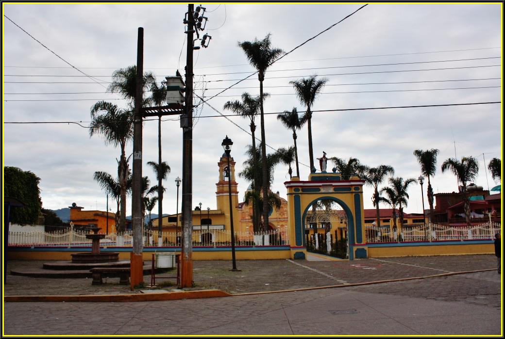
Town Tomatlán, Veracruz Altas Montañas (Orizaba and Córdoba)
Hill town between Córdoba and Coscomatepec: San Miguel parish, the Olmec site of La Yerbabuena, an 1805 arch bridge and a fiesta on 29 September.
From Córdoba: 25 min by car (21 km by road) How to get there ↓
Near here
See everything nearby ↓



Plan your visit to Tomatlán
Where to stay near Tomatlán
Compare hotels, posadas and guest houses in Tomatlán.
Tours to Tomatlán
Day trips around Coscomatepec sometimes stop in Tomatlán; a tour is the easy way to see it without a car.
 Tours from Veracruz
Private Sunrise Taj Mahal Tour from Delhi By Car -All inclusive
★ 5.0 (549) · From US$14
How to get to Tomatlán
- From Córdoba: about 25 min by road (~21 km)
- Nearest airport: Veracruz (VER), 1 h 50 min by car to Coscomatepec
Links open a partner site. We may earn a commission if you book, at no cost to you.
Tours from Veracruz, near Tomatlán


Tours, prices and ratings from Viator, checked weekly. We may earn a commission if you book.
About Tomatlán
Tomatlán is the seat of one of Veracruz's smallest municipalities, barely 19 km² of hill country in the centre of the state, wedged between Coscomatepec, Ixhuatlán del Café, Córdoba and Chocamán. The town, home to 4,415 people in 2020, stands at 1,362 metres in the Jamapa river basin, with a semi-warm, humid climate averaging 16 to 20 °C and rain in most months. The name is Nahuatl for "place where tomatoes abound".
People lived here long before the Spanish arrived. About 3 km east lies La Yerbabuena, an Olmec-period settlement that worked as a workshop for obsidian tools. It is the source of the stela known as Monument 1 or "El Rey", showing a local ruler wearing the headdress of the Olmec maize god. In the 15th century a settlement called Quechultenango, "wall of quetzals", was founded, and in colonial times the town was known as San Miguel Quechultenango Tomatlán. It became a municipality on 18 January 1825 and a free municipality in 1918.
The centre revolves around the parish church of San Miguel Arcángel and the town hall. Locals tell of a house with a five-pointed star set into its floor, linked to the trials by ordeal of colonial justice. Maps still mark the site of the old Tomatlán railway station. The economy rests on sugarcane and chicken farming, followed by coffee and cattle.
Beyond town, the rivers are the draw. On the Tlacotalpan there is a natural stone bridge, a huge boulder jammed between two rock walls that serves as a crossing; nearby are the Puente de Arco, built in 1805, the Cuevas de Carón and La Junta, or Paso Canoas, where the Tlacotalpan meets the Jamapa. The main fiesta honours San Miguel Arcángel on 29 September with a fair, dances and fireworks, and Holy Week brings a Passion play. Local cooking means mole de olla, rancho-style tamales, chilatole and sweets of tejocote, peach and chayote.
How to get to Tomatlán
Drive from Córdoba: 25 min, 21 km
From Coscomatepec, the neighbouring Pueblo Mágico, it is about 7 km, roughly 8 minutes, on Federal Highway 143 and Tomatlán's Avenida 1. From Córdoba it is about 20 km, around 25 minutes: head north on the Córdoba-Chocamán road, go through Chocamán and carry on to Tomatlán. From Orizaba allow about 33 km and just over half an hour, on the 150D toll road towards Córdoba and then Highway 143 towards Coscomatepec. From Huatusco it is about 26 km on Highways 125 and 143, some 27 minutes, and from Xalapa about 112 km, around two hours, via Coatepec and Huatusco. Long-distance ADO, AU and other buses arrive at the Terminal de Autobuses Córdoba (TAC); we found no published timetable for local transport to Tomatlán, so ask in Córdoba or Coscomatepec about services in the area.
Directions to Tomatlán on Google Maps
Distances are in a straight line; the road is usually longer.
Links open a partner site. We may earn a commission if you book, at no cost to you.
From the nearest cities to Tomatlán
- Córdoba · 21 km by road, 25 min
- Orizaba · 33 km by road, 35 min
- Tehuacán · 101 km by road, 1 h 30 min
Drive times by road from OpenStreetMap, without traffic or stops. Times marked ~ are estimated from the straight-line distance.
Visiting Tomatlán: what to see and do
The parish church of San Miguel Arcángel.
The archaeological site of La Yerbabuena, about 3 km east.
The natural stone bridge over the Tlacotalpan river.
The 1805 Puente de Arco and the Cuevas de Carón.
La Junta, or Paso Canoas, where the Tlacotalpan meets the Jamapa.
The San Miguel Arcángel fiesta on 29 September.
The site of the old Tomatlán railway station.
Plan your trip
Places to stay in Tomatlán
Compare hotels, posadas, and rentals in and around Tomatlán.
Tours & activities
Day trips around Coscomatepec sometimes stop in Tomatlán; a tour is the easy way to see it without a car.
Rental cars
Pick up a car at VER (Veracruz): about 1 h 50 min by road to Coscomatepec, then 6 km more to Tomatlán, on your own schedule.
Flights
The nearest airport with scheduled flights is Veracruz (VER), about 1 h 50 min by road from Coscomatepec, the base for Tomatlán.
Mobile data
Signal can drop away from Coscomatepec: download a map of the way to Tomatlán before you set out, or carry an eSIM with data.
Links open a partner site. We may earn a commission if you book, at no cost to you.
When to go to Tomatlán mild
Tomatlán shares the climate of Coscomatepec, 6 km away. The best months to visit are February, March, April, and December.
See the month-by-month climate of Coscomatepec
Weather in Tomatlán now and the next 7 days
Live forecast from Open-Meteo. Chance of rain is the day's highest.
The closest Pueblo Mágico: Coscomatepec

Coscomatepec is the Pueblo Mágico closest to Tomatlán, with places to stay, food, and more to see.
Also close to
Closest to Tomatlán
-
Monte Blanco · Village · 7 km away
-
Monte Salas · Village · 11 km away
-
Moyoapan · Village · 13 km away
-
Barranca de Metlac · Viewpoint · 14 km away
-
Cascada de Cocalzingo · Waterfall · 14 km away
-
Huatusco · Town · 14 km away
-
Sumidero · Village · 14 km away
-
Fortín de las Flores · Town · 15 km away


Near Tomatlán


Drive times by road from OpenStreetMap, without traffic. Times marked ~ are estimated from the straight-line distance.
Location from OpenStreetMap. Written by Puebloteca.