Landmark Barrio Mágico Museums Churches and shrines Indigenous roots Zacatecas
Zacatecas' first Indigenous quarter, settled by Mexica people north of the centre, with its last standing Indian chapel (1569-70); Barrio Mágico since 2024.
From Fresnillo: about 1 h by road (~70 km) How to get there ↓
Near here
See everything nearby ↓


Plan your visit to Mexicapan
Where to stay near Mexicapan
Compare hotels, posadas and guest houses in Mexicapan.
Tours to Mexicapan
Look for tours of the area around Guadalupe that stop at Mexicapan.
How to get to Mexicapan
- From Fresnillo: about 1 h by road (~70 km)
- Nearest airport: Zacatecas (ZCL), 34 min by car to Guadalupe
Links open a partner site. We may earn a commission if you book, at no cost to you.
About Mexicapan
Mexicapan is a quarter of steep cobbled streets on the northern slopes of the city of Zacatecas, a little over a kilometre from the cathedral. It is named after its first residents. The Mexica were the first Indigenous people to settle in Zacatecas after the silver veins were found, and their barrio, the city's first, grew up to the north, near the San Bernabé mines, the main stream and the Franciscan convent. Later, to the west, Tlaxcalan settlers formed Tlacuitlapan. Like the other Indian quarters, it sat on the edge of the Spanish centre, and its people worked in the mines and in the ore-processing haciendas of the north side, such as La Noria, La Pinta and Bracho.
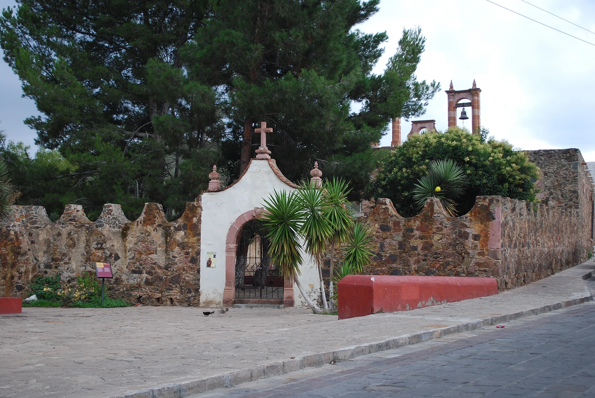
Its treasure is the Mexicapan chapel, which the Franciscans built in 1569-1570 beside the Camino Real de Tierra Adentro, the royal road between Zacatecas and Fresnillo. Its walls are rammed adobe faced with mine stone, the local building method, and it is the only Indian chapel still standing in the city. The Mexica dedicated it to the Assumption; today it is consecrated to the Virgin of Candelaria. It was altered in the 18th century, partly collapsed in 1939 and was abandoned; rescue work began in 1979, and canon José de Jesús López de Lara and Federico Sescosse completed its restoration in 1994. The atrium is closed by a stone wall topped with inverted arches.
The chapel belongs to the parish of Nuestro Padre Jesús, whose Templo de Jesús, a few blocks away, is the centre of the Holy Week processions. During that week the chapel holds a pulque fair meant to keep the customs of the barrio's founders alive, and Mexicapan is a place to find melcocha, Zacatecas' traditional pulled-sugar sweet.
Mexico's federal Tourism Secretariat (SECTUR) named Mexicapan a Barrio Mágico in June 2024, at the Tianguis Internacional de Pueblos Mágicos held in San Antonio, Texas; it is the first in Zacatecas.
How to get to Mexicapan
Mexicapan lies north of the historic centre, 1.1 km in a straight line from the cathedral; by car it is 1.4 km and about 3 minutes, but the centre is best explored on foot, up steep streets. The way into the barrio is just past the Museo Rafael Coronel, in the former Franciscan convent. Long-distance buses arrive at the Central de Autobuses, south of the centre, with direct services from most northern cities; from there it is about 5 km and 10 minutes by taxi without traffic, or a city bus toward the centre. General Leobardo C. Ruiz International Airport, near Víctor Rosales, has flights from Mexico City, Guadalajara, Monterrey and Tijuana and from several US cities; it is about 27 km and 30 minutes by road to Mexicapan. The cable car (10:00 to 18:00) leaves from Cerro del Grillo, a few blocks away, and rises to La Bufa.
Directions to Mexicapan on Google Maps
Distances are in a straight line; the road is usually longer.
Links open a partner site. We may earn a commission if you book, at no cost to you.
From the nearest cities to Mexicapan
- Fresnillo · about 70 km by road, ~1 h
- Aguascalientes · about 135 km by road, ~2 h
- Lagos de Moreno · about 225 km by road, ~3 h 20 min
Drive times by road from OpenStreetMap, without traffic or stops. Times marked ~ are estimated from the straight-line distance.
Before you go to Mexicapan: hours, prices and tips
- Best season
- Holy Week: processions from the Templo de Jesús and a pulque fair at the Mexicapan chapel. Imagen Zacatecas · checked Oct 2026
Hours and prices change, especially around holidays. Each fact links to where we checked it.
Visiting Mexicapan: what to see and do
See the Mexicapan chapel of 1569-1570, the only Indian chapel still standing in Zacatecas.
Notice its adobe walls faced with mine stone and the inverted-arch wall around the atrium.
Visit the Templo de Jesús, seat of the parish and of the Holy Week processions.
Go to the pulque fair the chapel holds during Holy Week.
Try melcocha, the traditional Zacatecas sweet.
Carry on to the Museo Rafael Coronel and the Cerro del Grillo cable car, which crosses above the city to La Bufa.
Plan your trip
Places to stay in Mexicapan
Compare hotels, posadas, and rentals in and around Mexicapan.
Tours & activities
Look for tours of the area around Guadalupe that stop at Mexicapan.
Rental cars
Pick up a car at ZCL (Zacatecas): about 34 min by road to Guadalupe, then 7 km more to Mexicapan, on your own schedule.
Flights
The nearest airport with scheduled flights is Zacatecas (ZCL), about 34 min by road from Guadalupe, the base for Mexicapan.
Mobile data
Signal can drop away from Guadalupe: download a map of the way to Mexicapan before you set out, or carry an eSIM with data.
Links open a partner site. We may earn a commission if you book, at no cost to you.
When to go to Mexicapan cool
Mexicapan shares the climate of Guadalupe, 7 km away. The best months to visit are January, March, April, and December.
See the month-by-month climate of Guadalupe
Weather in Mexicapan now and the next 7 days
Live forecast from Open-Meteo. Chance of rain is the day's highest.
The closest Pueblo Mágico: Guadalupe

Guadalupe is the Pueblo Mágico closest to Mexicapan, with places to stay, food, and more to see.
Also close to
- Jerez · Zacatecas · 47 km away
- Villanueva · Zacatecas · 58 km away
- Pabellón de Hidalgo · Aguascalientes · 72 km away
- San José de Gracia · Aguascalientes · 73 km away
- Real de Asientos · Aguascalientes · 78 km away
Closest to Mexicapan
-
Zacatecas · City · 1 km away
-
Vetagrande · Town · 6 km away
-
Tacoaleche · Town · 18 km away
-
La Quemada · Archaeological site · 45 km away
Near Mexicapan





Drive times by road from OpenStreetMap, without traffic. Times marked ~ are estimated from the straight-line distance.
Location from OpenStreetMap. Written by Puebloteca.