
Mountain Cuajimalpa de Morelos, Ciudad de México Municipality of Cuajimalpa de Morelos Valley of Mexico
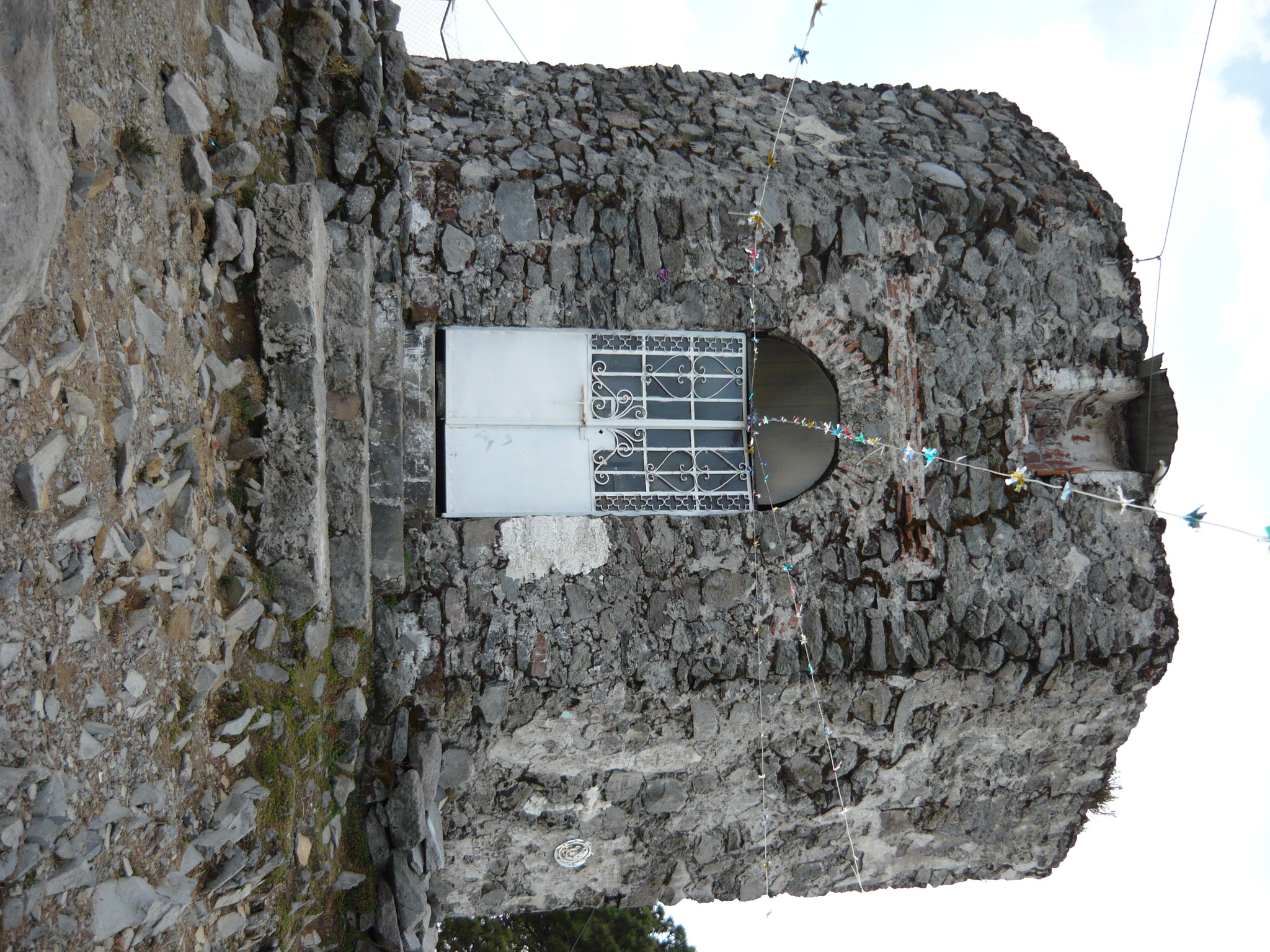
The summit of Desierto de los Leones park at about 3,790 m: an 18th-century Carmelite chapel, a fire tower and views to the volcanoes. A long hike.
From Mexico City: 45 min by car (34 km by road) How to get there ↓
Near here
See everything nearby ↓


Plan your visit to Cerro San Miguel
Where to stay near Cerro San Miguel
Compare hotels, posadas and guest houses in Cerro San Miguel.
Tours to Cerro San Miguel
Day trips and guided outings from Metepec often include Cerro San Miguel; with a local guide you can get there without a car.
 Tours from Mexico City
Teotihuacan pyramids morning or afternoon without tourist traps
★ 4.9 (10,269) · From US$59
How to get to Cerro San Miguel
- From Mexico City: about 45 min by road (~34 km)
- Nearest airport: Toluca (TLC), 17 min by car to Metepec
Links open a partner site. We may earn a commission if you book, at no cost to you.
Tours from Mexico City, near Cerro San Miguel


Tours, prices and ratings from Viator, checked weekly. We may earn a commission if you book.
About Cerro San Miguel
Cerro San Miguel is the highest point of the Desierto de los Leones National Park, in western Mexico City between Cuajimalpa and Álvaro Obregón. It rises to about 3,790 metres above sea level, and the park's main stream starts on its slopes at roughly 3,700 metres. The summit has a fire-watch tower and a small stone chapel built by the Carmelites of the Desierto monastery between 1722 and 1728. INAH reads it as a likely property marker and lookout dedicated to the Archangel Michael; it may also have been meant to Christianise an indigenous site, since old idols and objects have turned up there. At about 3,750 metres it may be the highest colonial building in the city.
There is no short stroll to it: the climb by forest trails takes six to eight hours round trip, and the park advises going with a local guide and following its conservation rules, because the area is fragile and home to the endangered teporingo, or volcano rabbit. From the chapel you can see the Valley of Mexico, the Toluca Valley, Popocatepetl and Iztaccihuatl about 70 km to the east and, about 50 km to the west, the Nevado de Toluca. The park is open daily from 6:00 to 17:00 and charges no entry fee.
How to get to Cerro San Miguel
Drive from Mexico City: 45 min, 34 km
By car: from the city centre it is about 21 km and roughly 45 minutes, with no toll, by the México-Toluca highway toward La Venta or the old route along Insurgentes Sur and San Ángel toward the Desierto. The park entrance is on the road from La Venta to Santa Rosa Xochiac, in Cuajimalpa; parking is free. By public transport: Metro Line 7 to Barranca del Muerto, then a bus toward Santa Rosa Xochiac to the last stop and a short taxi to the entrance (about 20 pesos); or take a bus from Tacubaya or Auditorio to Cuajimalpa and a taxi or shared vehicle from there to the main entrance. Allow 1 to 1.5 hours in total from the centre. The summit is reached on foot from the La Venta entrance or from the ex-convent along forest trails; there is no road for cars.
Directions to Cerro San Miguel on Google Maps
Distances are in a straight line; the road is usually longer.
Links open a partner site. We may earn a commission if you book, at no cost to you.
From the nearest cities to Cerro San Miguel
- Mexico City · 34 km by road, 45 min
- Toluca · 71 km by road, 1 h 20 min
- Cuernavaca · 80 km by road, 1 h 30 min
Drive times by road from OpenStreetMap, without traffic or stops. Times marked ~ are estimated from the straight-line distance.
Before you go to Cerro San Miguel: hours, prices and tips
- Hours
- The park is open daily from 6:00 to 17:00. El Universal · checked Oct 2026
- Entry
- Park access and parking are free; the city environment ministry says no one is authorised to charge for them. The Carmelite ex-convent charges separately. El Universal · checked Oct 2026
- Time needed
- The climb by forest trails takes six to eight hours round trip. Visit Mexico City (CDMX tourism) · checked Oct 2026
- Best time of day
- Start early, between 7 and 9 am, to avoid traffic and crowds at the entrances. Escapadah · checked Oct 2026
- Guide or tour
- A local guide is recommended, given the fragile terrain and the volcano rabbit's habitat. Tours: Viator GetYourGuide Visit Mexico City (CDMX tourism) · checked Oct 2026
- Rules
- Respect the opening hours, keep the park clean, stay on marked routes, leave pets at home, light no fires, do not smoke and do not remove plants or animals. El Universal · checked Oct 2026
Hours and prices change, especially around holidays. Each fact links to where we checked it.
Visiting Cerro San Miguel: what to see and do
The stone chapel of San Miguel, built by the Carmelites between 1722 and 1728.
The view from the top: Valley of Mexico, Toluca Valley, Popocatepetl, Iztaccihuatl and the Nevado de Toluca on clear days.
The fire-watch tower beside the park's highest point.
The park's forest, habitat of the endangered teporingo, or volcano rabbit.
The Carmelite ex-convent of the Desierto de los Leones, in the middle of the park, before or after the hike.
Plan your trip
Places to stay in Cerro San Miguel
Compare hotels, posadas, and rentals in and around Cerro San Miguel.
Tours & activities
Day trips and guided outings from Metepec often include Cerro San Miguel; with a local guide you can get there without a car.
Rental cars
Pick up a car at TLC (Toluca): about 17 min by road to Metepec, then 29 km more to Cerro San Miguel, on your own schedule.
Flights
The nearest airport with scheduled flights is Toluca (TLC), about 17 min by road from Metepec, the base for Cerro San Miguel.
Travel insurance
If you plan on hiking at altitude at Cerro San Miguel, check that your policy covers it: some plans leave adventure activities out.
Mobile data
Signal can drop away from Metepec: download a map of the way to Cerro San Miguel before you set out, or carry an eSIM with data.
Links open a partner site. We may earn a commission if you book, at no cost to you.
When to go to Cerro San Miguel cool
Cerro San Miguel shares the climate of Metepec, 29 km away. The best months to visit are January, February, March, and December.
For the clearest views from Cerro San Miguel, go in the driest months (January, February, March, and December); in the rains, clouds tend to build up by midday.
See the month-by-month climate of Metepec
Weather in Cerro San Miguel now and the next 7 days
Live forecast from Open-Meteo. Chance of rain is the day's highest.
The closest Pueblo Mágico: Metepec

Metepec is the Pueblo Mágico closest to Cerro San Miguel, with places to stay, food, and more to see.
Also close to
- Tepoztlán · Morelos · 39 km away
- Malinalco · Estado de México · 40 km away
- Tlayacapan · Morelos · 50 km away
- Tepotzotlán · Estado de México · 51 km away
- Xochitepec · Morelos · 53 km away
Closest to Cerro San Miguel
-
Desierto de los Leones · Nature reserve · 5 km away
-
La Marquesa · Nature reserve · 6 km away
-
Santa Rosa Xochiac · Village · 7 km away
-
Los Dinamos · Nature reserve · 8 km away
-
Salazar · Village · 8 km away
-
Ajusco · Mountain · 9 km away
-
Cerro Judío · Mountain · 9 km away
-
La Magdalena Contreras · Village · 9 km away


Near Cerro San Miguel
-
Parque nacional Fuentes Brotantes de Tlalpan · Nature reserve · Ciudad de México
35 min drive · 22 km


Drive times by road from OpenStreetMap, without traffic. Times marked ~ are estimated from the straight-line distance.
Lists with Cerro San Miguel
Mountains in Ciudad de México · 9 Mountains near Mexico City · 14 Mountains near Metepec · 10 Mountains near Toluca · 6 Mountains near Tepoztlán · 13 Mountains near Cuernavaca · 10 Mountains near Malinalco · 6 Mountains near Tlayacapan · 12Location from OpenStreetMap. Written by Puebloteca.