
Mountain La Magdalena Contreras, Ciudad de México Municipality of La Magdalena Contreras Valley of Mexico
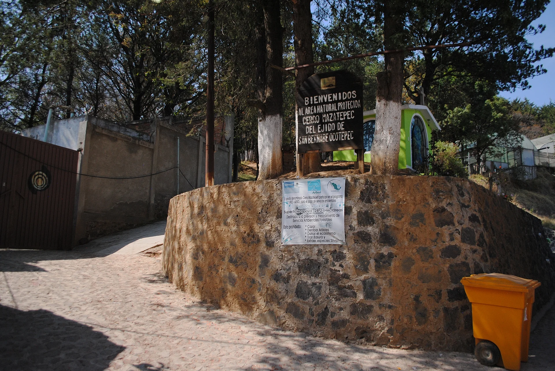
A 2,750 m hill above San Bernabé Ocotepec, with a restored Otomí pyramid, three crosses at the top and views over the city.
From Mexico City: 30 min by car (24 km by road) How to get there ↓
Near here
See everything nearby ↓


Plan your visit to Cerro Judío
Where to stay near Cerro Judío
Compare hotels, posadas and guest houses in Cerro Judío.
Tours to Cerro Judío
Day trips and guided outings from Metepec often include Cerro Judío; with a local guide you can get there without a car.
 Tours from Mexico City
Teotihuacan pyramids morning or afternoon without tourist traps
★ 4.9 (10,269) · From US$59
How to get to Cerro Judío
- From Mexico City: about 30 min by road (~24 km)
- Nearest airport: Toluca (TLC), 17 min by car to Metepec
Links open a partner site. We may earn a commission if you book, at no cost to you.
Tours from Mexico City, near Cerro Judío


Tours, prices and ratings from Viator, checked weekly. We may earn a commission if you book.
About Cerro Judío
Cerro del Judío, also called Cerro de las Tres Cruces, is a hill rising to 2,750 metres above sea level in the La Magdalena Contreras borough, on the south-western edge of Mexico City. Its oldest known name is Mazatépetl, Nahuatl for "hill of the deer"; several explanations circulate for the "Judío" nickname and none is confirmed.
The summit holds an Otomí settlement with a restored pyramid dated to about 1200. A turtle with jaguar claws is carved into its staircase, a figure tied to the fertility of the surrounding farmland, and the temple is believed to have honoured Ehécatl, the wind god. The finds from the ceremonial centre date from 1200 to 1380. INAH began recovering the site in 2000 under archaeologist Francisco Rivas, who considered the builders most likely Tepanec groups from the time of the Triple Alliance.
The hill belongs to the ejido of San Bernabé Ocotepec (383.49 hectares), is a protected natural area, and now operates as the Centro Ecoturístico Cerro Mazatépetl, offering guided visits and alternative-medicine workshops. Every Holy Week residents climb to the three crosses on the summit for religious ceremonies, alongside the feast of San Bernabé, patron saint of the village lying at the foot of the hill to the south. From the top a good part of the city spreads out below.
About 950 metres from the park, Mercado Cerro del Judío, renovated in 2017 and built with red-brick arches, is a handy place to eat or shop before the climb.
How to get to Cerro Judío
Drive from Mexico City: 30 min, 24 km
By car, the simplest way is to drive to the village of San Bernabé Ocotepec and climb from there towards the crosses. The market, at avenida San Bernabé and Independencia, is about 950 m from the park entrance. Times swing with traffic: from Polanco or Chapultepec the drive to Los Dinamos, in this same borough, is around 40 minutes.
By public transport, one option is Metro Viveros (Line 3) and then the ruta 42 Hidalgo-Capulines microbús, which climbs into this area. Another is to get off at Metro Tasqueña (Line 2, with the Tren Ligero, trolleybus and the Terminal Central de Autobuses del Sur) and continue by taxi or local transport towards La Magdalena Contreras. No Metrobús, trolleybus, Cablebús or train reaches the hill. The official listings give no opening hours or entry fee, so check before going.
Directions to Cerro Judío on Google Maps
Distances are in a straight line; the road is usually longer.
Links open a partner site. We may earn a commission if you book, at no cost to you.
From the nearest cities to Cerro Judío
- Mexico City · 24 km by road, 30 min
- Toluca · 58 km by road, 1 h 5 min
- Cuernavaca · 72 km by road, 1 h 15 min
Drive times by road from OpenStreetMap, without traffic or stops. Times marked ~ are estimated from the straight-line distance.
Before you go to Cerro Judío: hours, prices and tips
- Best season
- Holy Week is the busiest date: residents climb to the three summit crosses and San Bernabé is also celebrated. Wikipedia · checked Oct 2026
- Guide or tour
- Guided visits are offered at the Centro Ecoturístico Cerro Mazatépetl; whether they are mandatory is not published. Tours: Viator GetYourGuide Gobierno de la Ciudad de México, Turismo · checked Oct 2026
Hours and prices change, especially around holidays. Each fact links to where we checked it.
Visiting Cerro Judío: what to see and do
The restored Mazatépetl pyramid on the summit, with the jaguar-clawed turtle on its staircase.
The three summit crosses, where neighbours celebrate Holy Week.
Views over the city from 2,750 m.
Guided visits run by the Centro Ecoturístico Cerro Mazatépetl.
The village of San Bernabé Ocotepec and its church of San Bernabé Apóstol, about 1.1 km from the park.
Mercado Cerro del Judío, at avenida San Bernabé and Independencia.
Los Dinamos, the Magdalena River canyon in the same borough (see its page).
Plan your trip
Places to stay in Cerro Judío
Compare hotels, posadas, and rentals in and around Cerro Judío.
Tours & activities
Day trips and guided outings from Metepec often include Cerro Judío; with a local guide you can get there without a car.
Rental cars
Pick up a car at TLC (Toluca): about 17 min by road to Metepec, then 37 km more to Cerro Judío, on your own schedule.
Flights
The nearest airport with scheduled flights is Toluca (TLC), about 17 min by road from Metepec, the base for Cerro Judío.
Travel insurance
If you plan on hiking at altitude at Cerro Judío, check that your policy covers it: some plans leave adventure activities out.
Mobile data
Signal can drop away from Metepec: download a map of the way to Cerro Judío before you set out, or carry an eSIM with data.
Links open a partner site. We may earn a commission if you book, at no cost to you.
When to go to Cerro Judío cool
Cerro Judío shares the climate of Metepec, 37 km away. The best months to visit are January, February, March, and December.
For the clearest views from Cerro Judío, go in the driest months (January, February, March, and December); in the rains, clouds tend to build up by midday.
See the month-by-month climate of Metepec
Weather in Cerro Judío now and the next 7 days
Live forecast from Open-Meteo. Chance of rain is the day's highest.
The closest Pueblo Mágico: Metepec

Metepec is the Pueblo Mágico closest to Cerro Judío, with places to stay, food, and more to see.
Also close to
- Tepoztlán · Morelos · 41 km away
- Tepotzotlán · Estado de México · 44 km away
- Malinalco · Estado de México · 49 km away
- Tlayacapan · Morelos · 50 km away
- Villa del Carbón · Estado de México · 50 km away
Closest to Cerro Judío
-
La Magdalena Contreras · Village · 2 km away
-
Los Dinamos · Nature reserve · 2 km away
-
San Jerónimo Lídice · Village · 4 km away
-
Santa Rosa Xochiac · Village · 4 km away
-
Desierto de los Leones · Nature reserve · 6 km away
-
Bosque de Tlalpan · Nature reserve · 7 km away
-
Casa Estudio Diego Rivera y Frida Kahlo · Landmark · 7 km away
-
Ciudad Universitaria · Landmark · 7 km away


Near Cerro Judío
-
Parque nacional Fuentes Brotantes de Tlalpan · Nature reserve · Ciudad de México
20 min drive · 14 km


Drive times by road from OpenStreetMap, without traffic. Times marked ~ are estimated from the straight-line distance.
Lists with Cerro Judío
Mountains in Ciudad de México · 9 Mountains near Mexico City · 14 Mountains near Metepec · 10 Mountains near Tepoztlán · 13 Mountains near Toluca · 6 Mountains near Cuernavaca · 10 Mountains near Tepotzotlán · 13 Mountains near Malinalco · 6Location from OpenStreetMap. Written by Puebloteca.