Town Benito Juárez, Ciudad de México Valley of Mexico
A former town swallowed by the city in 1928: a kiosk plaza, a Dominican convent, Gómez Farías's house and an Aztec pyramid beside the Periférico.
From Mexico City: 15 min by car (11 km by road) How to get there ↓
Near here




Plan your visit to Mixcoac
Where to stay near Mixcoac
Compare hotels, posadas and guest houses in Mixcoac.
Tours to Mixcoac
Day trips around Tepotzotlán sometimes stop in Mixcoac; a tour is the easy way to see it without a car.
 Tours from Mexico City
Teotihuacan pyramids morning or afternoon without tourist traps
★ 4.9 (10,269) · From US$59
How to get to Mixcoac
- From Mexico City: about 15 min by road (~11 km)
- Nearest airport: Mexico City (Felipe Ángeles) (NLU), 48 min by car to Tepotzotlán
Links open a partner site. We may earn a commission if you book, at no cost to you.
Tours from Mexico City, near Mixcoac


Tours, prices and ratings from Viator, checked weekly. We may earn a commission if you book.
About Mixcoac
The name comes from the Nahuatl mixtli, cloud, and coatl, serpent: "in the cloud serpent", a nod to the Milky Way and the god Mixcóatl. Mixcoac began as a Tepanec settlement on the western shore of the lake, flourished around AD 1000 and became an Aztec tributary under Itzcóatl around 1420. Dominican friars set up a mission here around 1545, and the town remained a parish seat through the colonial period. In the late 19th century, like Tacubaya, San Ángel and Coyoacán, it filled with summer houses for families from the capital; in 1910 the municipality had 21,812 people, and that year the huge La Castañeda asylum opened, running until 1967. In 1928 Mixcoac stopped being a municipality and was folded into the city. Today it is a neighbourhood of the Benito Juárez borough between Insurgentes and the Periférico, and one of the city's designated Barrios Mágicos.
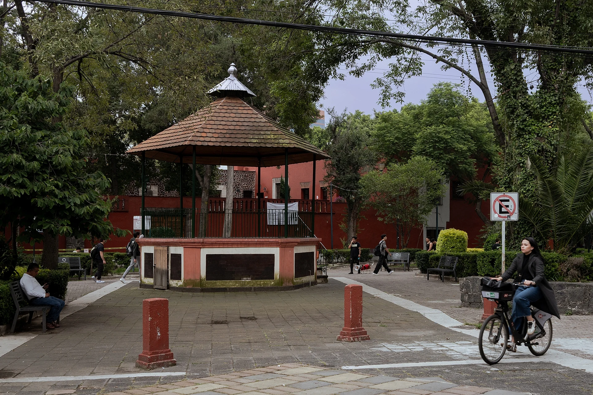
The old centre is still in one piece. Plaza Jáuregui has a cone-roofed kiosk, shade trees and benches where people play chess, ringed by red-painted houses. Beside it stands the parish of Santo Domingo de Guzmán: the convent was founded around 1595, the date of the porter's lodge arch and the cloister, and the church dates from 1648, with gilded baroque altarpieces in the Rosary chapel. At the end of the square the neoclassical former town hall is now the Centro Cultural Juan Rulfo, with 1979 murals by Eppens in its lobby, and across from it the Universidad Panamericana occupies the old textile workshop. On Plaza Gómez Farías, with its palms and fountain, number 12 was the home of president Valentín Gómez Farías and now houses the Instituto Mora; number 8 belonged to Irineo Paz, grandfather of Octavio Paz, who grew up here. Facing it is the church of San Juan Evangelista y Guadalupe, built after a typhus epidemic in 1675.
Two blocks from the Metro, the Mixcoac market has a flower hall and seafood stalls. Feast days are Santo Domingo on 8 August, the Virgin of Guadalupe on 12 December and Holy Week, with the Seven Houses visit, a fair, rides, wafers, buñuelos and tamales. To the north, beside the Periférico, the foundations of the pyramid of Mixcóatl survive, built by the Aztecs shortly before 1521.
How to get to Mixcoac
Drive from Mexico City: 15 min, 11 km
By Metro: Mixcoac station is on Line 7 (El Rosario–Barranca del Muerto) and is the terminal of Line 12 (Mixcoac–Tláhuac); Plaza Jáuregui is a walk from there. For the archaeological site, the nearest station is San Antonio on Line 7, one stop north.
By Metrobús: Line 1 runs along Insurgentes on the neighbourhood's eastern edge; the Río Churubusco stop is at the Circuito Interior, and Parque Hundido and Félix Cuevas are also close. Trolleybus lines 3 and 13 also serve Mixcoac.
By car: from the Zócalo it is about 14 km, some 16 minutes without traffic (much longer with it); Avenida Revolución and Avenida Patriotismo cross the neighbourhood, and you enter at the Glorieta de Goya, opposite Patriotismo. Parking in the old centre is hard, so the Metro is easier.
From Tepotzotlán it is about 47 km, roughly 45 minutes without traffic.
Directions to Mixcoac on Google Maps
Distances are in a straight line; the road is usually longer.
Links open a partner site. We may earn a commission if you book, at no cost to you.
From the nearest cities to Mixcoac
- Mexico City · 11 km by road, 15 min
- Toluca · 62 km by road, 1 h
- Cuernavaca · 71 km by road, 1 h 15 min
Drive times by road from OpenStreetMap, without traffic or stops. Times marked ~ are estimated from the straight-line distance.
What to see in Mixcoac 6
Sights with their own page, closest to the centre first.
Landmarks and museums
-
Casa Estudio Diego Rivera y Frida Kahlo · Landmark · 3 km from the centre
Juan O'Gorman's 1931 twin houses in San Ángel, a red one for Diego and a blue one for Frida, joined by a rooftop bridge behind a fence of cactus. -
Museo Frida Kahlo · Landmark · 3 km from the centre
Frida Kahlo's cobalt-blue Casa Azul in Coyoacán, where she was born and died: her studio, kitchen and garden. Tickets online only, by time slot. -
Presa Tacubaya · Landmark · 3 km from the centre
Flood-control dam from 1936 on the Tacubaya river, ringed by neighbourhoods; the El Insurgente train viaduct crosses its basin. -
Condesa · Landmark · 4 km from the centre
Art Deco colonia built around an old racetrack: oval Avenida Ámsterdam, Parque México and Parque España, and pavement cafés under jacarandas.
Nature reserves
-
Bosque de Chapultepec · Nature reserve · 4 km from the centre
More than 800 hectares of forest in four sections: rowboats on the lakes, a free zoo, the castle hill and the city's great museums.
Archaeological sites
-
Copilco · Archaeological site · 4 km from the centre
A Preclassic village buried under Xitle's lava, tunnelled into by Manuel Gamio in 1917; its site museum closed to the public in the early 1980s.

Map of Mixcoac
Neighbourhoods and villages of Mixcoac
Part of Mixcoac or just outside it, closest first.
-
Tacubaya · Village · 3 km from the centre
West Mexico City neighbourhood with Parque Lira, Casa de la Bola, Barragán's house and a hub of Metro, Metrobús and city buses. -
Coyoacán · Town · 4 km from the centre
Cortés's first seat of New Spain, later home to Frida Kahlo and Trotsky: twin plazas, a 16th-century parish, a market and cobbled streets. -
San Ángel · Town · 4 km from the centre
Cobbled lanes, a Carmelite convent with tiled domes and mummies, the Saturday art bazaar on Plaza San Jacinto, and Rivera and Kahlo's twin studios.


Day trips and tours from Mixcoac
The closest Pueblos Mágicos and places to visit, with the drive from Mixcoac and tours that leave from it.


Times marked ~ are estimated from the distance. Links open a partner site. We may earn a commission if you book, at no cost to you.
Before you go: getting to and around Mixcoac
- The nearest airport is Mexico City (Felipe Ángeles) (NLU).
- The best months to go are January, February, March, and December.
- 5 of the places on this page are more than 3 km from the centre: take a taxi, a ride-hailing app or a local bus.
- For day trips a rental car gives the most freedom; the tours above leave from Mixcoac.
Before you go to Mixcoac: hours, prices and tips
- Hours
- Mixcoac archaeological site: Tuesday to Sunday, 9 am to 5 pm. INAH · checked Oct 2026
- Entry
- Free entry to the archaeological site. INAH · checked Oct 2026
- Best season
- Feast of Santo Domingo on 8 August; Virgin of Guadalupe on 12 December; Holy Week with the Seven Houses visit and a fair with raffle, rides and fireworks. México Desconocido · checked Oct 2026
- Guide or tour
- The archaeological site has an information desk and guided tours. Tours: Viator GetYourGuide INAH · checked Oct 2026
Hours and prices change, especially around holidays. Each fact links to where we checked it.
Visiting Mixcoac: what to see and do
Sit in Plaza Jáuregui with its kiosk and red houses, and look at the Muro de la Paz beside it.
Step into Santo Domingo de Guzmán for its 1595 cloister and the gilded altarpieces of the Rosary chapel.
See the Eppens murals in the Centro Cultural Juan Rulfo, the old town hall.
Walk to Plaza Gómez Farías for the president's house (now the Instituto Mora), Irineo Paz's house and the church of San Juan Evangelista.
Eat seafood and buy flowers at the Mixcoac market, two blocks from the Metro.
Visit the Mixcoac archaeological site, with the pyramid of Mixcóatl, the central patio and adobe rooms, at Calle Pirámide 7.
Tour the Metro museum at Avenida Revolución 851, next to the station (Tuesday to Friday 10 am-6 pm, weekends 11 am-2 pm; free with a Metro ticket).
Plan your trip
Places to stay in Mixcoac
Compare hotels, posadas, and rentals in and around Mixcoac.
Tours & activities
Day trips around Tepotzotlán sometimes stop in Mixcoac; a tour is the easy way to see it without a car.
Rental cars
Pick up a car at NLU (Mexico City (Felipe Ángeles)): about 48 min by road to Tepotzotlán, then 38 km more to Mixcoac, on your own schedule.
Flights
The nearest airport with scheduled flights is Mexico City (Felipe Ángeles) (NLU), about 48 min by road from Tepotzotlán, the base for Mixcoac.
Mobile data
Signal can drop away from Tepotzotlán: download a map of the way to Mixcoac before you set out, or carry an eSIM with data.
Links open a partner site. We may earn a commission if you book, at no cost to you.
When to go to Mixcoac cool
Mixcoac shares the climate of Tepotzotlán, 38 km away. The best months to visit are January, February, March, and December.
See the month-by-month climate of Tepotzotlán
Weather in Mixcoac now and the next 7 days
Live forecast from Open-Meteo. Chance of rain is the day's highest.
The closest Pueblo Mágico: Tepotzotlán

Tepotzotlán is the Pueblo Mágico closest to Mixcoac, with places to stay, food, and more to see.
Also close to
- Tepoztlán · Morelos · 44 km away
- Metepec · Estado de México · 45 km away
- Villa del Carbón · Estado de México · 49 km away
- Teotihuacán · Estado de México · 50 km away
- Tlayacapan · Morelos · 52 km away
Near Mixcoac


Drive times by road from OpenStreetMap, without traffic. Times marked ~ are estimated from the straight-line distance.
Location from OpenStreetMap. Written by Puebloteca.