Village Huixquilucan, Estado de México Municipality of Huixquilucan Valley of Mexico
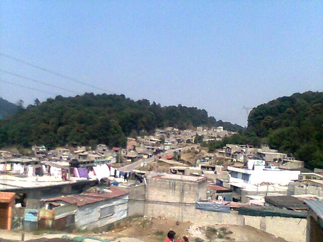
High Huixquilucan community among Sierra de las Cruces pines at nearly 3,000 m, on the Naucalpan–Toluca road, with real cold in winter.
From Mexico City: 35 min by car (30 km by road) How to get there ↓
Near here
See everything nearby ↓


Plan your visit to El Hielo
Where to stay near El Hielo
Compare hotels, posadas and guest houses in El Hielo.
Tours to El Hielo
Day trips and guided outings from Metepec often include El Hielo; with a local guide you can get there without a car.
 Tours from Mexico City
Teotihuacan pyramids morning or afternoon without tourist traps
★ 4.9 (10,269) · From US$59
How to get to El Hielo
- From Mexico City: about 35 min by road (~30 km)
- Nearest airport: Toluca (TLC), 17 min by car to Metepec
Links open a partner site. We may earn a commission if you book, at no cost to you.
Tours from Mexico City, near El Hielo


Tours, prices and ratings from Viator, checked weekly. We may earn a commission if you book.
About El Hielo
El Hielo lies in the upper part of Huixquilucan, in the Sierra de las Cruces among pine woods, at around 3,000 m (sources give anywhere from 2,991 to 3,027). The name makes sense once you know the weather: the municipality lists it among the places with the lowest winter temperatures (0 to 5 °C in the high parts of Huixquilucan) and hands out blankets there every cold season. Pueblos de América puts the annual mean at 10.8 °C, January at 8.1 °C, and the heaviest snowfall since 1970 at 1.2 cm, in March 1983.
In 2020 it had 3,794 residents. Because of its size it has been split into neighbourhoods called parajes: La Cumbre, El Chinaco, La Guadalupe, Bosques del Guarda, Colosio, Piedra Larga, La Capilla, Vista del Valle and El Hielo Centro. It borders San José Tejamanil (Naucalpan) to the north, Santa Cruz Ayotuxco to the south, San Francisco Chimalpa to the east and the colonia El Guarda to the west. Most streets have electricity, drainage and paving, there is a DIF family centre offering health services and classes, and part of the water arrives by tanker truck.
It is not a tourist destination. Wikipedia treats it as a barrio of La Magdalena Chichicaspa, whose big feasts are 22 July (Santa María Magdalena) and 8 December. What it offers is mountain air and the pine forest, a little over 7 km north of Naucalpan.
How to get to El Hielo
Drive from Mexico City: 35 min, 30 km
El Hielo sits on the Naucalpan–Toluca highway (federal 134), roughly between km 20 and km 25, before you reach Xonacatlán and San Francisco Xochicuautla. In a straight line it is about 9 km west of Huixquilucan de Degollado and about 7 km north of Naucalpan. By public transport two bus groups serve it: the Línea México Tacuba–Huixquilucan y Anexas, which runs to Cuatro Caminos and El Rosario metro stations, and the Asociación de Propietarios y Autotransportistas de Huixquilucan, which goes to the municipal seat. Times depend on Toluca-highway traffic. There is no published published timetables for these routes; ask at the stops.
Directions to El Hielo on Google Maps
Distances are in a straight line; the road is usually longer.
Links open a partner site. We may earn a commission if you book, at no cost to you.
From the nearest cities to El Hielo
- Mexico City · 30 km by road, 35 min
- Toluca · 43 km by road, 40 min
- Cuernavaca · 104 km by road, 1 h 40 min
Drive times by road from OpenStreetMap, without traffic or stops. Times marked ~ are estimated from the straight-line distance.
Before you go to El Hielo: hours, prices and tips
- Best season
- Cold defines the place: from December to March the municipality runs its winter operation and the high parts of the municipality, El Hielo among them, see 0 to 5 °C; May is the warmest month, averaging 13 °C. El Universal; Pueblos de América · checked Oct 2026
- What to bring
- Bring a jacket even if the city is warm: at nearly 3,000 m nights are cool all year. Pueblos de América · checked Oct 2026
Hours and prices change, especially around holidays. Each fact links to where we checked it.
Visiting El Hielo: what to see and do
Walk among the pines of the upper Sierra de las Cruces, with cool air most of the year.
Wander El Hielo Centro and its parajes, such as La Cumbre, Piedra Larga and Vista del Valle.
Notice how climate and vegetation change compared with Naucalpan, about 7 km south.
If your dates allow, go to the feast of Santa María Magdalena in La Magdalena Chichicaspa on 22 July.
Plan your trip
Places to stay in El Hielo
Compare hotels, posadas, and rentals in and around El Hielo.
Tours & activities
Day trips and guided outings from Metepec often include El Hielo; with a local guide you can get there without a car.
Rental cars
Pick up a car at TLC (Toluca): about 17 min by road to Metepec, then 33 km more to El Hielo, on your own schedule.
Flights
The nearest airport with scheduled flights is Toluca (TLC), about 17 min by road from Metepec, the base for El Hielo.
Mobile data
Signal can drop away from Metepec: download a map of the way to El Hielo before you set out, or carry an eSIM with data.
Links open a partner site. We may earn a commission if you book, at no cost to you.
When to go to El Hielo cool
El Hielo shares the climate of Metepec, 33 km away. The best months to visit are January, February, March, and December.
See the month-by-month climate of Metepec
Weather in El Hielo now and the next 7 days
Live forecast from Open-Meteo. Chance of rain is the day's highest.
The closest Pueblo Mágico: Metepec

Metepec is the Pueblo Mágico closest to El Hielo, with places to stay, food, and more to see.
Also close to
- Tepotzotlán · Estado de México · 35 km away
- Villa del Carbón · Estado de México · 35 km away
- Malinalco · Estado de México · 55 km away
- Tepoztlán · Morelos · 56 km away
- Jilotepec · Estado de México · 61 km away
Closest to El Hielo
-
Magdalena Chichicaspa · Town · 3 km away
-
Huixquilucan de Degollado · Town · 7 km away
-
Jesús del Monte · Town · 8 km away
-
San Luis Ayucan · Village · 8 km away
-
Naucalpan · City · 9 km away
-
San Pedro Cuajimalpa · Town · 9 km away
-
San Francisco Xochicuautla · Village · 11 km away
-
Desierto de los Leones · Nature reserve · 13 km away


Near El Hielo


Drive times by road from OpenStreetMap, without traffic. Times marked ~ are estimated from the straight-line distance.
Location from OpenStreetMap. Written by Puebloteca.