Town Ocoyoacac, Estado de México Municipality of Ocoyoacac Toluca Valley
A town between Toluca and La Marquesa: San Martín Obispo parish, tamales de ollita, a Wednesday market and a patron-saint feast on 11 November.
From Toluca: 25 min by car (23 km by road) How to get there ↓
Near here


Plan your visit to Ocoyoacac
Where to stay near Ocoyoacac
Compare hotels, posadas and guest houses in Ocoyoacac.
Tours to Ocoyoacac
Day trips around Metepec sometimes stop in Ocoyoacac; a tour is the easy way to see it without a car.
 Tours from Mexico City
Teotihuacan pyramids morning or afternoon without tourist traps
★ 4.9 (10,269) · From US$59
How to get to Ocoyoacac
- From Toluca: about 25 min by road (~23 km)
- Nearest airport: Toluca (TLC), 17 min by car to Metepec
Links open a partner site. We may earn a commission if you book, at no cost to you.
Tours from Mexico City, near Ocoyoacac


Tours, prices and ratings from Viator, checked weekly. We may earn a commission if you book.
About Ocoyoacac
Ocoyoacac sits right where the highway from Mexico City drops off the Monte de Las Cruces into the Toluca valley, about 18 km from the state capital and close to the Lerma River. The town had 29,068 residents in 2020 and lies at roughly 2,600 m. Its name was given by the Aztec ruler Axayácatl when he conquered the Matlatzinco valley around 1476: "where the ocote pines begin". Long before that, between about AD 450 and 650, a residential and ceremonial centre called Tlalcozpan, "on the yellow earth", flourished here under Teotihuacan influence.
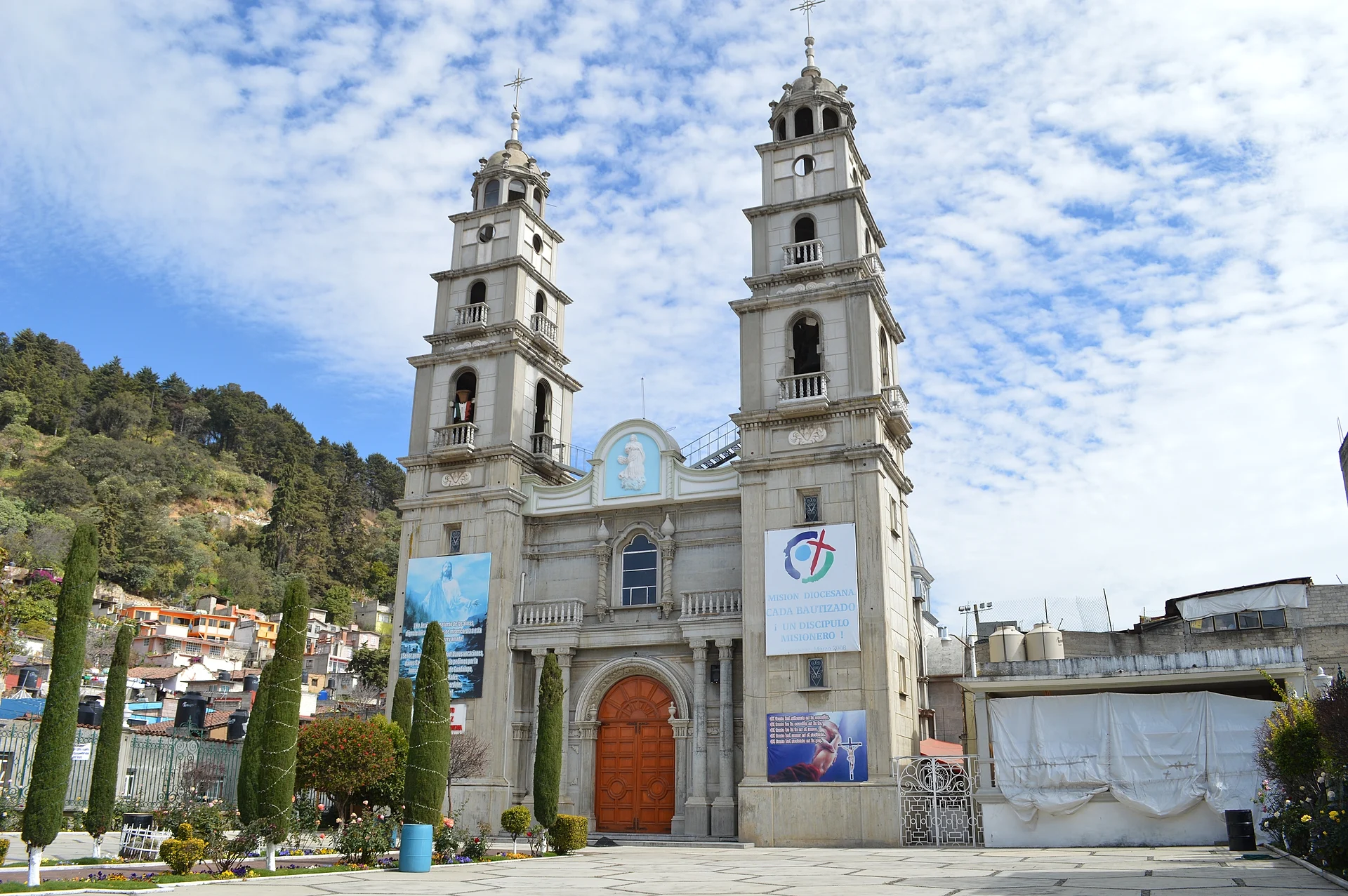
In 1521 the local chief Chimaltécatl allied himself with Hernán Cortés, who named him governor and founder of the town and charged him with building a church to Saint Martin. That first church was finished around 1560, burned in 1703 and was pulled down in 1750 to make way for the present parish church, with its Neoclassical front facing the main square and town hall. The town is divided into the barrios of Santa María, San Miguel and Santiaguito, each with its own chapel, and became a municipality in 1820.
Most visitors come for the forest. A large part of the Miguel Hidalgo National Park, better known as La Marquesa, lies within the municipality, and its valleys, among them El Zarco, El Silencio, Salazar and La Cima, are where people rent horses, eat trout and barbacoa and picnic. On the Monte de Las Cruces, Miguel Hidalgo's insurgents fought Torcuato Trujillo on 30 October 1810, and the obelisk Manuel Tolsá designed in 1795 for the Mexico City–Toluca road still stands there. In town, the thing to eat is the tamal de ollita or chuchuluco, a hollow tamal filled with runny salsa and pork, taken with a mug of atole. The market sets up on Wednesdays, Saturdays and Sundays, with Wednesday the biggest. The feast of San Martín falls on 11 November, with arriero and Moors-and-Christians dances and fireworks towers made by local pyrotechnicians.
How to get to Ocoyoacac
Drive from Toluca: 25 min, 23 km
From Mexico City leave by Avenida Constituyentes and take the México–Toluca toll road (15D) over La Marquesa; once over the pass, leave the toll road for Federal Highway 15 and drive into Ocoyoacac. From Observatorio it is about 38 km, roughly 40 minutes without traffic. From Toluca head east on Paseo Tollocan (Highway 15), about 22 km or 25 minutes; Metepec, the nearest of our pueblos, is about 17 km away via Las Torres, roughly 25 minutes.
By bus, Flecha Roja runs roughly hourly between the Terminal Poniente (Observatorio) and Ocoyoacac.
Directions to Ocoyoacac on Google Maps
Distances are in a straight line; the road is usually longer.
Links open a partner site. We may earn a commission if you book, at no cost to you.
From the nearest cities to Ocoyoacac
- Toluca · 23 km by road, 25 min
- Mexico City · 47 km by road, 50 min
- Cuernavaca · 70 km by road, 1 h 25 min
Drive times by road from OpenStreetMap, without traffic or stops. Times marked ~ are estimated from the straight-line distance.
Map of Ocoyoacac
Neighbourhoods and villages of Ocoyoacac
Part of Ocoyoacac or just outside it, closest first.
-
Amomolulco · Village · 4 km from the centre
A village in Lerma 2.4 km from Lerma's centre, with a listed former hacienda, Villa Carmela, and a Nahuatl name that speaks of water. -
San Jerónimo Acazulco · Town · 4 km from the centre
An Otomí town in Ocoyoacac whose communal land takes in much of La Marquesa's valleys; a mole fair in July and a New Year fiesta. -
San Miguel Ameyalco · Village · 4 km from the centre
Lerma village with an 18th-century parish, 462 steps up to Cristo Rey and a San Miguel fiesta of fireworks towers and oyamel log poles.
Day trips and tours from Ocoyoacac
The closest Pueblos Mágicos and places to visit, with the drive from Ocoyoacac and tours that leave from it.


Times marked ~ are estimated from the distance. Links open a partner site. We may earn a commission if you book, at no cost to you.
Before you go: getting to and around Ocoyoacac
- The nearest airport is Toluca (TLC).
- The best months to go are January, February, March, and December.
- 3 of the places on this page are more than 3 km from the centre: take a taxi, a ride-hailing app or a local bus.
- For day trips a rental car gives the most freedom; the tours above leave from Ocoyoacac.
Before you go to Ocoyoacac: hours, prices and tips
- Hours
- Street market in town on Wednesdays, Saturdays and Sundays; Wednesday is the biggest day. Wikipedia: Municipio de Ocoyoacac · checked Oct 2026
- Best season
- Feast of San Martín Obispo on 11 November, with a parade of floats the Sunday before; carnival before Lent and barrio feasts such as San Miguel on the first Sunday of October. Enciclopedia de los Municipios de México (INAFED) · checked Oct 2026
Hours and prices change, especially around holidays. Each fact links to where we checked it.
Visiting Ocoyoacac: what to see and do
The 1750 parish church of San Martín Obispo on the main square.
The barrio chapels of Santa María, San Miguel and Santiaguito.
The José María Luis Mora museum beside the municipal archive and library, and the Casa de Cultura.
The Wednesday market, with tamales de ollita and atole.
Manuel Tolsá's obelisk and the monuments to the battle of Monte de Las Cruces.
The valleys of La Marquesa: El Zarco, El Silencio, Salazar and La Cima.
The colonial-era haciendas of Jajalpa and Texcalpa.
Plan your trip
Places to stay in Ocoyoacac
Compare hotels, posadas, and rentals in and around Ocoyoacac.
Tours & activities
Day trips around Metepec sometimes stop in Ocoyoacac; a tour is the easy way to see it without a car.
Rental cars
Pick up a car at TLC (Toluca): about 17 min by road to Metepec, then 15 km more to Ocoyoacac, on your own schedule.
Flights
The nearest airport with scheduled flights is Toluca (TLC), about 17 min by road from Metepec, the base for Ocoyoacac.
Mobile data
Signal can drop away from Metepec: download a map of the way to Ocoyoacac before you set out, or carry an eSIM with data.
Links open a partner site. We may earn a commission if you book, at no cost to you.
When to go to Ocoyoacac cool
Ocoyoacac shares the climate of Metepec, 15 km away. The best months to visit are January, February, March, and December.
See the month-by-month climate of Metepec
Weather in Ocoyoacac now and the next 7 days
Live forecast from Open-Meteo. Chance of rain is the day's highest.
The closest Pueblo Mágico: Metepec

Metepec is the Pueblo Mágico closest to Ocoyoacac, with places to stay, food, and more to see.
Also close to
- Malinalco · Estado de México · 36 km away
- Tepoztlán · Morelos · 49 km away
- Villa del Carbón · Estado de México · 51 km away
- Ixtapan de la Sal · Estado de México · 53 km away
- Tepotzotlán · Estado de México · 55 km away
Near Ocoyoacac


Drive times by road from OpenStreetMap, without traffic. Times marked ~ are estimated from the straight-line distance.
Location from OpenStreetMap. Written by Puebloteca.