City Coacalco de Berriozábal, Estado de México Valley of Mexico
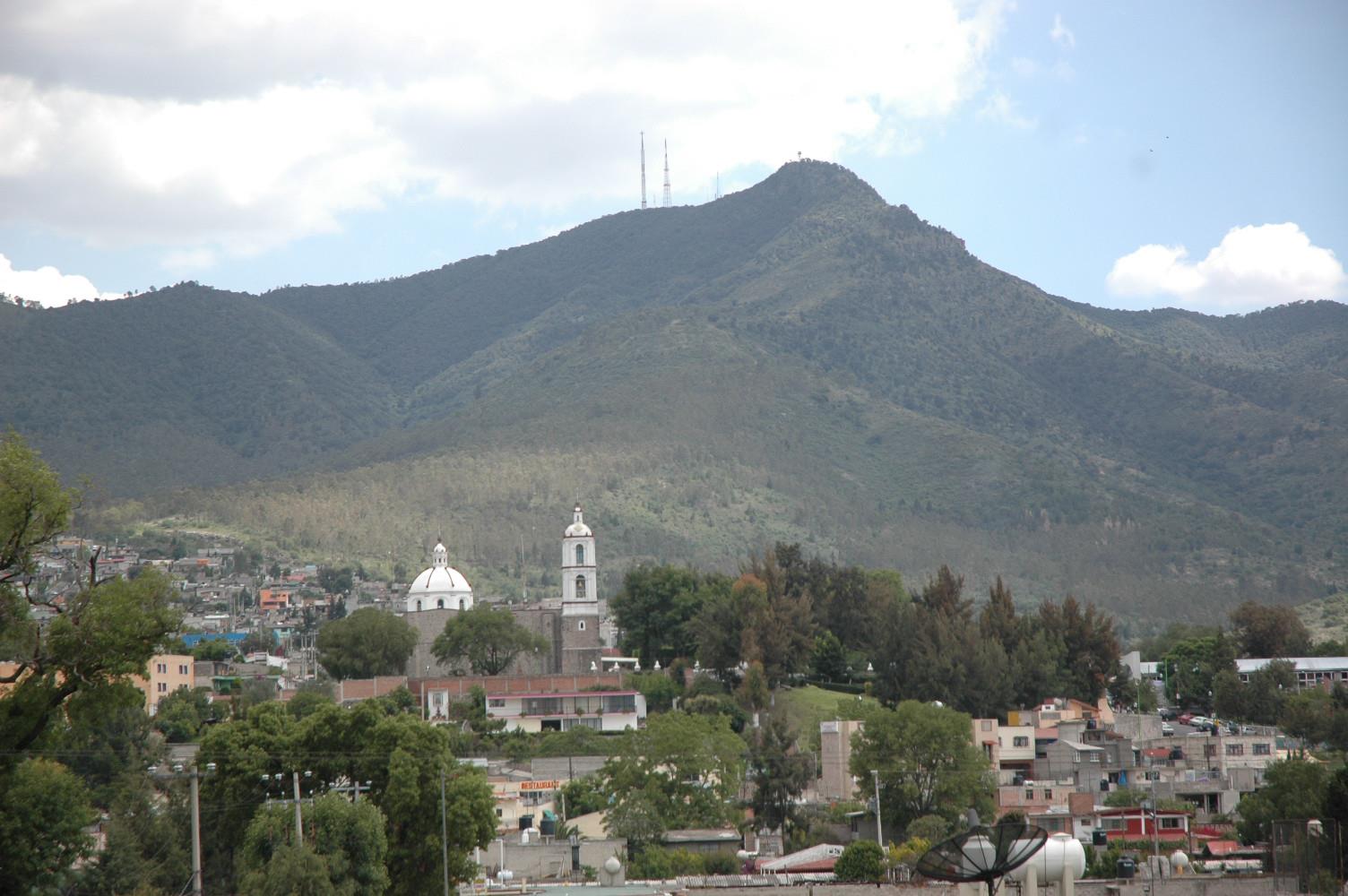
Seat of Coacalco de Berriozábal: a Franciscan parish begun in 1580, an organ from 1791 and the Sierra de Guadalupe behind it.
From Mexico City: 35 min by car (34 km by road) How to get there ↓
Near here
See everything nearby ↓


Plan your visit to San Francisco Coacalco
Where to stay near San Francisco Coacalco
Compare hotels, posadas and guest houses in San Francisco Coacalco.
Tours to San Francisco Coacalco
Day trips and guided outings from Tepotzotlán often include San Francisco Coacalco; with a local guide you can get there without a car.
 Tours from Mexico City
Teotihuacan pyramids morning or afternoon without tourist traps
★ 4.9 (10,269) · From US$59
How to get to San Francisco Coacalco
- From Mexico City: about 35 min by road (~34 km)
- Nearest airport: Mexico City (Felipe Ángeles) (NLU), 48 min by car to Tepotzotlán
Links open a partner site. We may earn a commission if you book, at no cost to you.
Tours from Mexico City, near San Francisco Coacalco


Tours, prices and ratings from Viator, checked weekly. We may earn a commission if you book.
About San Francisco Coacalco
San Francisco Coacalco is the seat of Coacalco de Berriozábal municipality, just north of Mexico City, and holds almost all of its people: about 293,000 in 2020. The name is Nahuatl and is usually read as "at the house of the snake"; it is already recorded in 1320. Until 1862 the town answered to Ecatepec. On 12 February that year Governor Felipe Berriozábal signed the decree making it a municipality, which is where the surname comes from. The farming and salt-making village changed from 1966 with the Villa de las Flores housing estate and, in 1969, Parque Residencial Coacalco, and today it is mostly a commercial corridor.
For a visitor the old centre is the point. The parish of San Francisco de Asís was begun in 1580 and finished around the early 1600s; reused stones from an earlier pre-Hispanic structure show in its walls. A boundary wall encloses the atrium, with Stations of the Cross and a sundial. The façade and tower combine late Baroque and early Neoclassical, the interior holds 17th-century paintings, and the upper choir has an Iberian-style organ dated 1791, restored recently by Eduardo Bribiesca. In the Palacio Municipal a 172 m² mural by Ariosto Otero, "Historia y Símbolos Patrios", covers the stairwell, and the council chamber keeps the act that created the municipality.
The feast of San Francisco on 4 October brings a fair and a friendship lunch the following Monday. To the north rises the Sierra de Guadalupe, with trails and recreation areas, and the malls (Plaza Coacalco, Cosmopol) line the Vía José López Portillo.
How to get to San Francisco Coacalco
Drive from Mexico City: 35 min, 34 km
By car: from Mexico City take the Mexico–Pachuca toll highway (85D) and enter Coacalco by the Vía José López Portillo, the municipality's main avenue. The Circuito Exterior Mexiquense (an 18.4 km alternate route through the municipality) links it with its neighbours. The centre is about 23 km in a straight line from Mexico City, roughly 40 minutes without traffic and much more at rush hour.
By public transport: Mexibús Line 2 runs along the Vía José López Portillo between La Quebrada in Cuautitlán Izcalli and Las Américas in Ecatepec, and connects with Line 1 in Ecatepec. From the stops you reach the parish by combi or taxi. Tepotzotlán, the nearest pueblo, is about 16 km as the crow flies, roughly 25 minutes by car.
Directions to San Francisco Coacalco on Google Maps
Distances are in a straight line; the road is usually longer.
Links open a partner site. We may earn a commission if you book, at no cost to you.
From the nearest cities to San Francisco Coacalco
- Mexico City · 34 km by road, 35 min
- Pachuca · 75 km by road, 1 h
- Toluca · 90 km by road, 1 h 15 min
Drive times by road from OpenStreetMap, without traffic or stops. Times marked ~ are estimated from the straight-line distance.
Before you go to San Francisco Coacalco: hours, prices and tips
- Best time of day
- The feast of San Francisco de Asís, on 4 October, brings the Expoferia and a friendship lunch the following Monday. Wikipedia (es): Coacalco de Berriozábal · checked Oct 2026
Hours and prices change, especially around holidays. Each fact links to where we checked it.
Visiting San Francisco Coacalco: what to see and do
The parish of San Francisco de Asís: Baroque-Neoclassical façade, 17th-century paintings and the 1791 organ in the upper choir.
The atrium and its wall, with Stations of the Cross and a sundial.
Ariosto Otero's mural in the Palacio Municipal.
The Sierra de Guadalupe, for walking and views over the valley.
The feast of San Francisco on 4 October, with a fair.
Plan your trip
Places to stay in San Francisco Coacalco
Compare hotels, posadas, and rentals in and around San Francisco Coacalco.
Tours & activities
Day trips and guided outings from Tepotzotlán often include San Francisco Coacalco; with a local guide you can get there without a car.
Rental cars
Pick up a car at NLU (Mexico City (Felipe Ángeles)): about 48 min by road to Tepotzotlán, then 16 km more to San Francisco Coacalco, on your own schedule.
Flights
The nearest airport with scheduled flights is Mexico City (Felipe Ángeles) (NLU), about 48 min by road from Tepotzotlán, the base for San Francisco Coacalco.
Mobile data
Signal can drop away from Tepotzotlán: download a map of the way to San Francisco Coacalco before you set out, or carry an eSIM with data.
Links open a partner site. We may earn a commission if you book, at no cost to you.
When to go to San Francisco Coacalco cool
San Francisco Coacalco shares the climate of Tepotzotlán, 16 km away. The best months to visit are January, February, March, and December.
See the month-by-month climate of Tepotzotlán
Weather in San Francisco Coacalco now and the next 7 days
Live forecast from Open-Meteo. Chance of rain is the day's highest.
The closest Pueblo Mágico: Tepotzotlán

Tepotzotlán is the Pueblo Mágico closest to San Francisco Coacalco, with places to stay, food, and more to see.
Also close to
- Teotihuacán · Estado de México · 28 km away
- Otumba · Estado de México · 37 km away
- Villa del Carbón · Estado de México · 39 km away
- Zempoala · Hidalgo · 55 km away
- Jilotepec · Estado de México · 57 km away
Closest to San Francisco Coacalco
-
Santa María Cuautepec · Village · 3 km away
-
Santiago Teyahualco · Town · 3 km away
-
Fuentes del Valle · Town · 4 km away
-
San Pablo de las Salinas · City · 4 km away
-
Tultepec · Town · 6 km away
-
Tultitlán de Mariano Escobedo · Town · 7 km away
-
Buenavista · City · 8 km away
-
Cuautitlán · City · 8 km away


Near San Francisco Coacalco


Drive times by road from OpenStreetMap, without traffic. Times marked ~ are estimated from the straight-line distance.
Location from OpenStreetMap. Written by Puebloteca.