
Village Juárez Hidalgo, Hidalgo
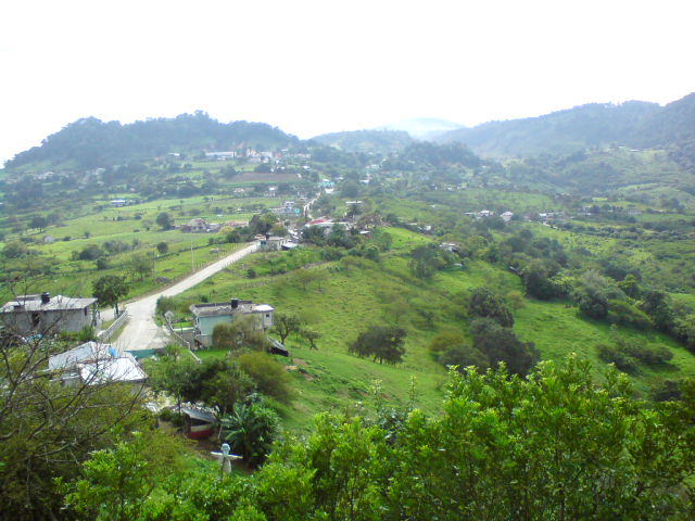
Municipal seat of 616 people at 1,605 m in the Sierra Alta, once called San Guillermo, with a 16th-century church with a churrigueresque facade.
From Pachuca: 2 h 15 min by car (128 km by road) How to get there ↓
Near here
See everything nearby ↓


Plan your visit to Juárez Hidalgo
Where to stay near Juárez Hidalgo
Compare hotels, posadas and guest houses in Juárez Hidalgo.
Tours to Juárez Hidalgo
Day trips and guided outings from Metztitlán often include Juárez Hidalgo; with a local guide you can get there without a car.
 Tours from Xilitla
Surrealist Garden of Edward James, Castle of Health and Xilitla Nativity
★ 4.3 (10) · From US$100
How to get to Juárez Hidalgo
- From Pachuca: about 2 h 15 min by road (~128 km)
- Nearest airport: Mexico City (Felipe Ángeles) (NLU), 2 h 18 min by car to Metztitlán
Links open a partner site. We may earn a commission if you book, at no cost to you.
Tours from Xilitla, near Juárez Hidalgo


Tours, prices and ratings from Viator, checked weekly. We may earn a commission if you book.
About Juárez Hidalgo
Juárez is the seat of the municipality of Juárez Hidalgo, in the Sierra Alta, at 1,605 metres on a plateau of the Carso Huasteco. It recorded 616 people in 2020, well below the 956 of 1921; its highest figure in recent decades was 735, in 2010. Before the Conquest the site was called Itzlapanitla; with evangelisation it became San Guillermo, a name it kept until the Revolution, and the present one joins the names of two heroes, Benito Juárez and Miguel Hidalgo.
The climate is semi-dry and semi-warm, averaging about 17 °C with 1,500 mm of rain, a high figure for the region. Water drains to the Amajac river sub-basin, and the rivers La Piedra Colorada, Ocotenango and Abrevadero cross the municipality. The hills carry red ocote pine, oak, pine and palm, with willows, poplars and quince on field edges; birds include the mockingbird, goldfinch and meadowlark. The municipality's most important crop is coffee (458 hectares in 2015), ahead of maize.
The church of San Guillermo, from the 16th century, has a churrigueresque facade and is the main monument. In the plaza stand a statue of Benito Juárez, another of Leona Vicario and a bust of Hidalgo. INEGI lists leather jackets, saddle upholstery, gloves, bags, petacas and belts among the crafts; tamales are made in banana leaf, with chile or bean fillings, and sweets use piloncillo and walnut.
How to get to Juárez Hidalgo
Drive from Pachuca: 2 h 15 min, 128 km
State road HGO 37 runs through the village; OpenStreetMap labels it Calle Miguel Hidalgo y Costilla as it crosses the centre, and other streets include Francisco I. Madero and Benito Juárez. Eloxochitlán is about 4.5 km away in a straight line, Molango about 10.5 km and Metztitlán about 22 km.
From Pachuca, Rome2rio estimates about 122 km and 1 h 59 min by car to Molango. By bus there is no direct service from Pachuca to Molango: Rome2rio suggests going to Mexico City's Terminal Central del Norte and taking Autobuses Conexión to Molango, every four hours and about 4 h 12 min, or combining Futura to Indios Verdes with Conexión (about 6 h 16 min in all). Confirm local transport from Molango to Juárez Hidalgo.
Directions to Juárez Hidalgo on Google Maps
Distances are in a straight line; the road is usually longer.
Links open a partner site. We may earn a commission if you book, at no cost to you.
From the nearest cities to Juárez Hidalgo
- Pachuca · 128 km by road, 2 h 15 min
- San Juan del Río · about 165 km by road, ~2 h 25 min
- Ciudad Valles · about 175 km by road, ~2 h 35 min
Drive times by road from OpenStreetMap, without traffic or stops. Times marked ~ are estimated from the straight-line distance.
Visiting Juárez Hidalgo: what to see and do
The church of San Guillermo, from the 16th century, with a churrigueresque facade.
The statues of Benito Juárez and Leona Vicario and the bust of Miguel Hidalgo.
The panoramic view of the village and the mountains around it, as in the cover photo.
The municipality's coffee plantations, its main crop.
Leather crafts: jackets, gloves, bags, petacas and belts.
Plan your trip
Places to stay in Juárez Hidalgo
Compare hotels, posadas, and rentals in and around Juárez Hidalgo.
Tours & activities
Day trips and guided outings from Metztitlán often include Juárez Hidalgo; with a local guide you can get there without a car.
Rental cars
Pick up a car at NLU (Mexico City (Felipe Ángeles)): about 2 h 18 min by road to Metztitlán, then 23 km more to Juárez Hidalgo, on your own schedule.
Flights
The nearest airport with scheduled flights is Mexico City (Felipe Ángeles) (NLU), about 2 h 18 min by road from Metztitlán, the base for Juárez Hidalgo.
Mobile data
Signal can drop away from Metztitlán: download a map of the way to Juárez Hidalgo before you set out, or carry an eSIM with data.
Links open a partner site. We may earn a commission if you book, at no cost to you.
When to go to Juárez Hidalgo mild
Juárez Hidalgo shares the climate of Metztitlán, 23 km away. The best months to visit are January, February, March, and December.
See the month-by-month climate of Metztitlán
Weather in Juárez Hidalgo now and the next 7 days
Live forecast from Open-Meteo. Chance of rain is the day's highest.
The closest Pueblo Mágico: Metztitlán

Metztitlán is the Pueblo Mágico closest to Juárez Hidalgo, with places to stay, food, and more to see.
Also close to
- Zimapán · Hidalgo · 58 km away
- Mineral del Chico · Hidalgo · 65 km away
- Huasca de Ocampo · Hidalgo · 69 km away
- Xilitla · San Luis Potosí · 69 km away
- Real del Monte · Hidalgo · 73 km away
Closest to Juárez Hidalgo
-
Hualula · Village · 8 km away
-
Laguna de Atezca · Lake · 9 km away
-
Molango · Town · 10 km away
-
Laguna de Metztitlán · Lake · 12 km away
-
Lolotla · Village · 14 km away
-
Acapa · Village · 15 km away
-
Alumbres · Village · 19 km away
-
Grutas de Tolantongo · Hot springs · 23 km away

Near Juárez Hidalgo


Drive times by road from OpenStreetMap, without traffic. Times marked ~ are estimated from the straight-line distance.
Location from OpenStreetMap. Written by Puebloteca.