Beach La Huerta, Jalisco Municipality of La Huerta
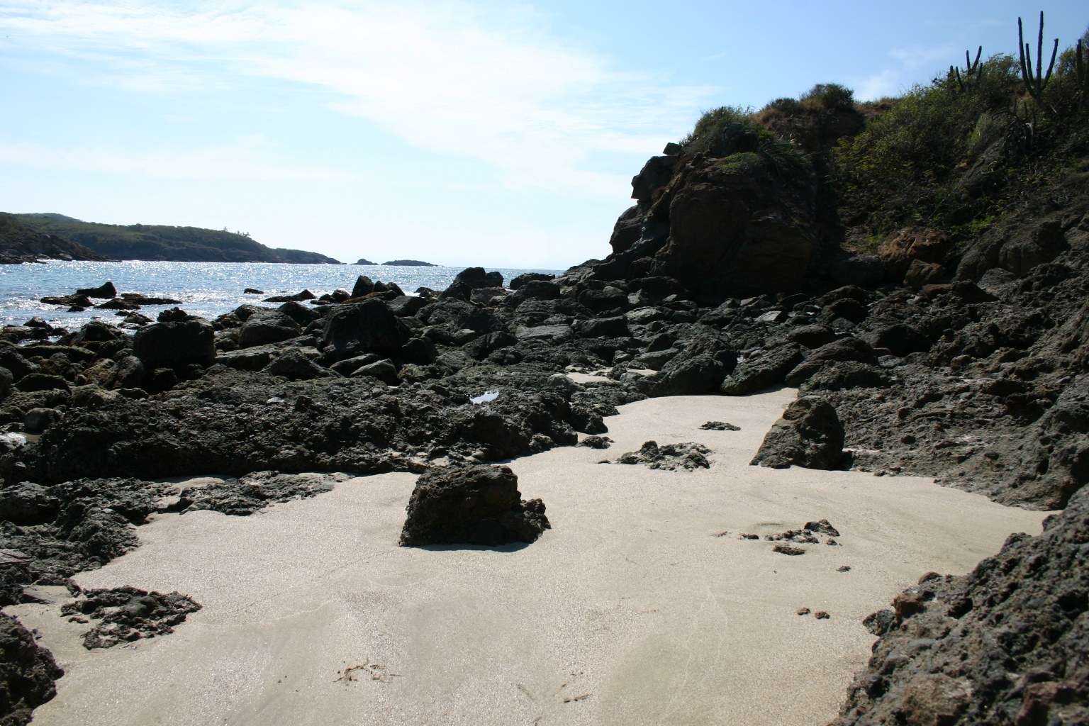
Pale-sand cove among dark rocks at the south end of Chamela Bay, facing La Negrita island; a couple of restaurants and no hotels.
From Autlán: about 1 h 30 min by road (~105 km) How to get there ↓
Near here
See everything nearby ↓


Plan your visit to El Negrito
Where to stay near El Negrito
Compare hotels, posadas and guest houses in El Negrito.
Tours to El Negrito
Day trips and guided outings from Talpa de Allende often include El Negrito; with a local guide you can get there without a car.
 Tours from Manzanillo
Private Chichen Itza & Yaxunah Ruins with Cenote
★ 4.8 (111) · From US$518
How to get to El Negrito
- From Autlán: about 1 h 30 min by road (~105 km)
- Nearest airport: Puerto Vallarta (PVR), 2 h 23 min by car to Talpa de Allende
Links open a partner site. We may earn a commission if you book, at no cost to you.
Tours from Manzanillo, near El Negrito


Tours, prices and ratings from Viator, checked weekly. We may earn a commission if you book.
About El Negrito
El Negrito is a short beach at the southern tip of Chamela Bay, in La Huerta municipality on Jalisco's south coast. It lies less than a kilometre west of Chamela village, on the sea side of federal Highway 200, reached by the turn-off at kilometre 64. It is a pale-sand cove boxed in by outcrops of dark rock, with low dry forest and columnar cacti on the bluffs above.
There are no hotels on the beach, just a couple of restaurants, and it is usually close to empty. About 600 metres offshore to the southwest sits La Negrita, the southernmost of the nine islands scattered across the bay, with San Andrés a little further out. They are all part of the nature sanctuary the federal government decreed on 9 April 2001, so they are for looking at and photographing rather than landing on casually. At sunset the sun drops behind them and turns them into silhouettes.
Half a kilometre north, the Chamela creek reaches the sea, and beyond its mouth come Chamela beach and Xametla. When the water is calm the rocks of the cove are good for snorkelling, and paths along the shore lead to other small inlets. Next to the village is the Chamela airstrip, a 1,164-metre dirt runway for light aircraft that serves the bay's hotel zone.
How to get to El Negrito
El Negrito is off federal Highway 200 (Manzanillo-Puerto Vallarta), at the km 64 turn-off by Chamela village, where a short road drops to the sea. From Manzanillo, head north on 200 past Barra de Navidad, Cihuatlán and Careyes: 1 h 40 min from Manzanillo, 131 km by road. The nearest Pueblo Mágico is Talpa de Allende, 3 h 40 min and 183 km by road. Without a car, buses run from Guadalajara to La Huerta (about 4 h 30 min), and from there a taxi or colectivo continues to the bay.
Directions to El Negrito on Google Maps
Distances are in a straight line; the road is usually longer.
Links open a partner site. We may earn a commission if you book, at no cost to you.
From the nearest cities to El Negrito
- Autlán · about 105 km by road, ~1 h 30 min
- Manzanillo · about 125 km by road, ~1 h 50 min
- Puerto Vallarta · about 165 km by road, ~2 h 25 min
Drive times by road from OpenStreetMap, without traffic or stops. Times marked ~ are estimated from the straight-line distance.
Before you go to El Negrito: hours, prices and tips
- Entry
- Public beach with no entry fee; best visited in daylight. Programa Destinos México · checked Oct 2026
- Best time of day
- November to May, the dry season, with clear skies for the sunsets. Programa Destinos México · checked Oct 2026
Hours and prices change, especially around holidays. Each fact links to where we checked it.
Visiting El Negrito: what to see and do
The pale-sand cove between outcrops of dark rock
La Negrita island, about 600 m southwest, with San Andrés island behind it
The bay's islands in silhouette at sunset
Snorkelling among the rocks when the sea is calm
The coastal paths to other small inlets
The mouth of the Chamela creek, half a kilometre north
La Viuda, a seafood and home-cooking palapa at km 64 of Highway 200
Plan your trip
Places to stay in El Negrito
Compare hotels, posadas, and rentals in and around El Negrito.
Tours & activities
Day trips and guided outings from Talpa de Allende often include El Negrito; with a local guide you can get there without a car.
Rental cars
Pick up a car at PVR (Puerto Vallarta): about 2 h 23 min by road to Talpa de Allende, then 99 km more to El Negrito, on your own schedule.
Flights
The nearest airport with scheduled flights is Puerto Vallarta (PVR), about 2 h 23 min by road from Talpa de Allende, the base for El Negrito.
Travel insurance
If you plan on swimming or surfing at El Negrito, check that your policy covers it: some plans leave adventure activities out.
Mobile data
Signal can drop away from Talpa de Allende: download a map of the way to El Negrito before you set out, or carry an eSIM with data.
Links open a partner site. We may earn a commission if you book, at no cost to you.
When to go to El Negrito mild
El Negrito shares the climate of Talpa de Allende, 99 km away. The best months to visit are January, March, November, and December.
El Negrito is best for swimming and time on the water in the warmest months (April, May, and June); in the rainiest ones (July, August, and September) expect storms in the afternoon.
See the month-by-month climate of Talpa de Allende
Weather in El Negrito now and the next 7 days
Live forecast from Open-Meteo. Chance of rain is the day's highest.
The closest Pueblo Mágico: Talpa de Allende

Talpa de Allende is the Pueblo Mágico closest to El Negrito, with places to stay, food, and more to see.
Closest to El Negrito
-
Chamela · Village · 1 km away
-
Xametla · Beach · 1 km away
-
Careyes · Town · 11 km away
-
Reserva de la Biosfera Chamela-Cuixmala · Nature reserve · 11 km away
-
Emiliano Zapata · Village · 20 km away
-
La Manzanilla · Village · 41 km away
-
La Huerta · Town · 47 km away
-
Tomatlán · Town · 49 km away


Near El Negrito


Drive times by road from OpenStreetMap, without traffic. Times marked ~ are estimated from the straight-line distance.
Lists with El Negrito
Beaches in Jalisco · 22Location from OpenStreetMap. Written by Puebloteca.