
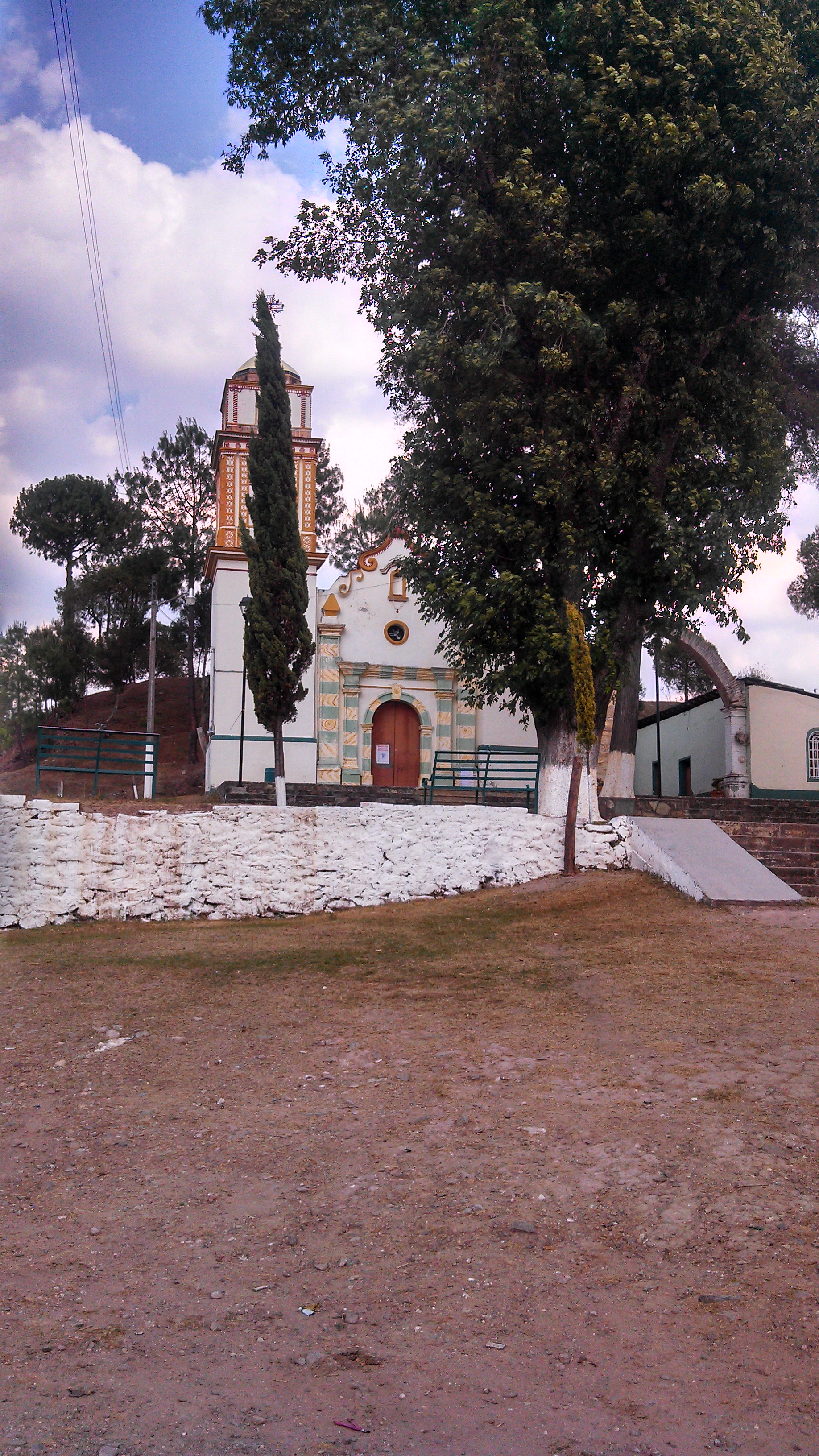
Village San Martín Huamelúlpam, Oaxaca Mixteca of Oaxaca
Mixtec village at 2,226 m with a church holding a pre-Hispanic effigy and a community museum; the ruins have their own page.
From Huajuapan de León: 1 h 35 min by car (87 km by road) How to get there ↓
Near here
See everything nearby ↓


Plan your visit to San Martín Huamelulpan
Where to stay near San Martín Huamelulpan
Compare hotels, posadas and guest houses in San Martín Huamelulpan.
Tours to San Martín Huamelulpan
Day trips and guided outings from Teposcolula often include San Martín Huamelulpan; with a local guide you can get there without a car.
How to get to San Martín Huamelulpan
- From Huajuapan de León: about 1 h 35 min by road (~87 km)
- Nearest airport: Oaxaca (OAX), 1 h 45 min by car to Teposcolula
Links open a partner site. We may earn a commission if you book, at no cost to you.
About San Martín Huamelulpan
With 114 residents in 2020 (113 in 2010), San Martín Huamelúlpam is the seat of a municipality in the Mixteca Alta, in the Tlaxiaco district, at about 2,226 m above sea level. The name comes from Nahuatl and is usually read as "on the mound of amaranth"; in Mixtec it is Yucunindaba, "the hill that flew". The ruins of the ancient city that made the place known have their own page in this guide; this one is about what is in the village.
The parish church of San Martín has a pre-Hispanic limestone sculpture set into one wall, about 1.20 m tall: a skeletal figure shown from the front, with claws on its limbs and a heart-like organ in the chest. The features recall the tzitzimime, beings of Nahua tradition; no one knows whether it came from the Mixtec city or is later work. After the Conquest it was common to reuse pre-Hispanic carvings in churches and houses.
The Hitalulu community museum ("Flor Bonita"), run by a village committee, is open Monday to Sunday from 10:00 to 17:00. It shows finds and data from the early city, urns of Dzahui, the rain god, and a hall of traditional medicine covering empacho, mal de aire, espanto and childbirth. Its activities include printmaking and silkscreen workshops, embroidery on manta cloth and carving of wooden spoons.
The patron saint's fiesta, for Saint Martin of Tours, is on 11 November; another is held on the fifth Friday of Lent for the Precious Blood of Christ. Those are the best days to find the village lively.
How to get to San Martín Huamelulpan
Drive from Huajuapan de León: 1 h 35 min, 87 km
From the city of Oaxaca, follow the highway toward Tlaxiaco and Teposcolula (passing through Nochixtlán). The turn-off to San Martín Huamelulpan is at km 36 of that road, according to INAH, and from there the village is about 1 km, which is where the museum stands. The whole drive from Oaxaca takes about 2 h 10 min by car according to Rome2rio. From Teposcolula it is about 20 to 25 minutes south on highway 125 toward Tlaxiaco; from Tlaxiaco it is less.
By bus: Rome2rio lists one Fypsa departure a day from Oaxaca to Tlaxiaco taking about 3 h; OCC also serves the Oaxaca-Teposcolula-Tlaxiaco corridor (leaving from Oaxaca's ADO terminal, on Calzada Niños Héroes de Chapultepec) and has departures from Teposcolula to Tlaxiaco from 4:35 am. Those timetables are old; confirm with the company. Ask the driver to drop you at the Huamelulpan turn-off and walk the last kilometre, or ask in Teposcolula or Tlaxiaco for vans that pass by.
Directions to San Martín Huamelulpan on Google Maps
Distances are in a straight line; the road is usually longer.
Links open a partner site. We may earn a commission if you book, at no cost to you.
From the nearest cities to San Martín Huamelulpan
- Huajuapan de León · 87 km by road, 1 h 35 min
- Tlapa · about 135 km by road, ~2 h
- Oaxaca · 144 km by road, 2 h
Drive times by road from OpenStreetMap, without traffic or stops. Times marked ~ are estimated from the straight-line distance.
Before you go to San Martín Huamelulpan: hours, prices and tips
- Hours
- Hitalulu community museum: Monday to Sunday, 10:00 to 17:00. Museos Comunitarios de América, Huamelulpam · checked Oct 2026
- Best season
- Fiestas: 11 November (Saint Martin of Tours) and the fifth Friday of Lent (Precious Blood of Christ). Wikipedia, San Martín Huamelúlpam · checked Oct 2026
Hours and prices change, especially around holidays. Each fact links to where we checked it.
Visiting San Martín Huamelulpan: what to see and do
Find the pre-Hispanic effigy set into a wall of the church of San Martín.
Go into the Hitalulu community museum, open 10:00 to 17:00 daily.
Ask at the museum about the traditional medicine hall.
Walk up to the ancient city's ruins beside the village.
Come on 11 November, the feast of Saint Martin of Tours.
Plan your trip
Places to stay in San Martín Huamelulpan
Compare hotels, posadas, and rentals in and around San Martín Huamelulpan.
Tours & activities
Day trips and guided outings from Teposcolula often include San Martín Huamelulpan; with a local guide you can get there without a car.
Rental cars
Pick up a car at OAX (Oaxaca): about 1 h 45 min by road to Teposcolula, then 17 km more to San Martín Huamelulpan, on your own schedule.
Flights
The nearest airport with scheduled flights is Oaxaca (OAX), about 1 h 45 min by road from Teposcolula, the base for San Martín Huamelulpan.
Mobile data
Signal can drop away from Teposcolula: download a map of the way to San Martín Huamelulpan before you set out, or carry an eSIM with data.
Links open a partner site. We may earn a commission if you book, at no cost to you.
When to go to San Martín Huamelulpan cool
San Martín Huamelulpan shares the climate of Teposcolula, 17 km away. The best months to visit are January, February, March, and December.
See the month-by-month climate of Teposcolula
Weather in San Martín Huamelulpan now and the next 7 days
Live forecast from Open-Meteo. Chance of rain is the day's highest.
The closest Pueblo Mágico: Teposcolula

Teposcolula is the Pueblo Mágico closest to San Martín Huamelulpan, with places to stay, food, and more to see.
Closest to San Martín Huamelulpan
-
Huamelulpan · Archaeological site · 0 km away
-
Santa Cruz Tayata · Town · 6 km away
-
Santa Catarina Tayata · Town · 7 km away
-
Santiago Yolomécatl · Town · 9 km away
-
San Juan Achiutla · Village · 12 km away
-
San Miguel Achiutla · Landmark · 16 km away
-
Tlaxiaco · Town · 17 km away
-
San Juan Teposcolula · Town · 25 km away


Near San Martín Huamelulpan







Drive times by road from OpenStreetMap, without traffic. Times marked ~ are estimated from the straight-line distance.
Location from OpenStreetMap. Written by Puebloteca.