


Town Alto Lucero de Gutiérrez Barrios, Veracruz Xalapa and the coffee hills
Hill town in the foothills of the Sierra de Chiconquiaco, about 35 km from Xalapa, hometown of the singer Paquita la del Barrio.
From Xalapa: 40 min by car (40 km by road) How to get there ↓
Near here
See everything nearby ↓


Plan your visit to Alto Lucero
Where to stay near Alto Lucero
Compare hotels, posadas and guest houses in Alto Lucero.
Tours to Alto Lucero
Day trips around Naolinco sometimes stop in Alto Lucero; a tour is the easy way to see it without a car.
 Tours from Veracruz
Private Sunrise Taj Mahal Tour from Delhi By Car -All inclusive
★ 5.0 (546) · From US$14
How to get to Alto Lucero
- From Xalapa: about 40 min by road (~40 km)
- Nearest airport: Veracruz (VER), 1 h 55 min by car to Naolinco
Links open a partner site. We may earn a commission if you book, at no cost to you.
Tours from Veracruz, near Alto Lucero


Tours, prices and ratings from Viator, checked weekly. We may earn a commission if you book.
About Alto Lucero
Alto Lucero is the seat of the municipality of Alto Lucero de Gutiérrez Barrios, in central Veracruz, about 35 km from the state capital, Xalapa. The town sits on a high shelf in the foothills of the Sierra de Chiconquiaco, at a little over 1,100 m, and had 5,238 people at the 2020 census; the whole municipality, which runs from the coffee-growing hills down to the Gulf of Mexico coast, had 28,184 in 137 localities. The municipality's coat of arms shows the town on its mesa under a morning star, with the maize, sugar cane, cattle and mangoes of the lowlands and the coffee of the sierra. Farming is mostly rain-fed, and the main crops are mango, banana, tomato, sugar cane, coffee and maize.
The area was originally Totonac. According to the Diccionario Enciclopédico Veracruzano, the Spanish founded a settlement called Pacheco in 1708, and in 1860 its people, driven out by unhealthy conditions, moved to the present site, which took the name Alto Lucero Pacheco in honour of their leader, Cecilia Lucero Pacheco. The area belonged to Actopan until 15 January 1930, when sixteen congregaciones were separated to form the new municipality. On 29 January 1991 the state congress renamed it Alto Lucero de Gutiérrez Barrios after Fernando Gutiérrez Barrios, governor of Veracruz and later federal interior minister, whose government built the road between Alto Lucero and Xalapa. Mexico's only nuclear power station, Laguna Verde, was built in the 1970s on the coast of the municipality, near Punta Limón.
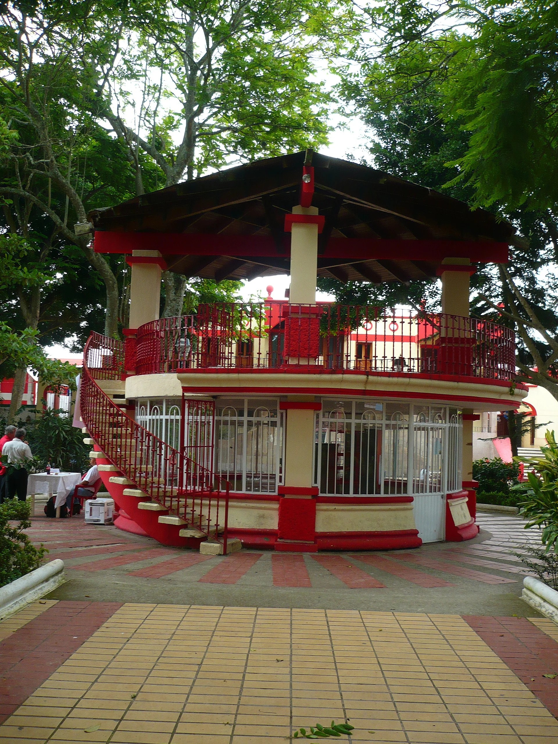
Alto Lucero is best known as the birthplace and childhood home of the ranchera singer Paquita la del Barrio (1947–2025). After her death in February 2025 the town held a mass for her at the parish of Cristo Rey del Universo and a public homage on its esplanade, with her portrait, her ashes and her songs. Cristo Rey is the town's patron, and his fiesta is held in November. The centre is a small square with shade trees, red benches and a two-storey red-and-cream kiosk, and the town is reached by a winding road through the hills. Typical local food includes ranch-style tamales, pepitas, chiles rellenos and longaniza.
How to get to Alto Lucero
Drive from Xalapa: 40 min, 40 km
Alto Lucero is about 35–40 km from Xalapa, roughly 45 minutes by car on the paved road built in the Gutiérrez Barrios years. From the coast, a winding two-lane state road climbs to the town from Federal Highway 180, the Cardel–Nautla coastal highway that passes Palma Sola and the Laguna Verde plant.
Directions to Alto Lucero on Google Maps
Distances are in a straight line; the road is usually longer.
Links open a partner site. We may earn a commission if you book, at no cost to you.
From the nearest cities to Alto Lucero
- Xalapa · 40 km by road, 40 min
- Córdoba · about 110 km by road, ~1 h 35 min
- Veracruz · 111 km by road, 1 h 40 min
Drive times by road from OpenStreetMap, without traffic or stops. Times marked ~ are estimated from the straight-line distance.
Before you go to Alto Lucero: hours, prices and tips
- Best season
- Fiesta of Cristo Rey, the town's patron, in November; Holy Week in spring. Enciclopedia de los Municipios de México (INAFED) · checked Oct 2026
Hours and prices change, especially around holidays. Each fact links to where we checked it.
Visiting Alto Lucero: what to see and do
Sit in the shady main square with its red-and-cream two-storey kiosk.
Visit the parish of Cristo Rey, where the town said farewell to Paquita la del Barrio in 2025.
Come for the fiesta of Cristo Rey, the patron, in November.
Try ranch-style tamales and local longaniza.
Head down to the coast of the municipality, with the beach at Palma Sola on Federal Highway 180.
Plan your trip
Places to stay in Alto Lucero
Compare hotels, posadas, and rentals in and around Alto Lucero.
Tours & activities
Day trips around Naolinco sometimes stop in Alto Lucero; a tour is the easy way to see it without a car.
Rental cars
Pick up a car at VER (Veracruz): about 1 h 55 min by road to Naolinco, then 15 km more to Alto Lucero, on your own schedule.
Flights
The nearest airport with scheduled flights is Veracruz (VER), about 1 h 55 min by road from Naolinco, the base for Alto Lucero.
Mobile data
Signal can drop away from Naolinco: download a map of the way to Alto Lucero before you set out, or carry an eSIM with data.
Links open a partner site. We may earn a commission if you book, at no cost to you.
Photos
When to go to Alto Lucero mild
Alto Lucero shares the climate of Naolinco, 15 km away. The best months to visit are February, March, April, and December.
See the month-by-month climate of Naolinco
Weather in Alto Lucero now and the next 7 days
Live forecast from Open-Meteo. Chance of rain is the day's highest.
The closest Pueblo Mágico: Naolinco

Naolinco is the Pueblo Mágico closest to Alto Lucero, with places to stay, food, and more to see.
Also close to
- Coatepec · Veracruz · 30 km away
- Xico · Veracruz · 36 km away
- Teziutlán · Puebla · 70 km away
- Coscomatepec · Veracruz · 70 km away
Closest to Alto Lucero
-
Coyolillo · Village · 7 km away
-
Trapiche del Rosario · Village · 9 km away
-
Los Otates · Village · 12 km away
-
Acatlán · Town · 14 km away
-
Chiconquiaco · Town · 16 km away
-
El Castillo · Village · 16 km away
-
Landero y Coss · Town · 17 km away
-
Miahuatlán · Town · 17 km away


Near Alto Lucero


Drive times by road from OpenStreetMap, without traffic. Times marked ~ are estimated from the straight-line distance.
Location from OpenStreetMap. Written by Puebloteca.