
Village Teocuitatlán de Corona, Jalisco
Seat of a municipality in the Lagunas region, about 64 km south of Guadalajara on the Ciudad Guzmán road, with the San José de Gracia parish.
From Ciudad Guzmán: 1 h by car (70 km by road) How to get there ↓
Near here
See everything nearby ↓


Plan your visit to Teocuitatlán de Corona
Where to stay near Teocuitatlán de Corona
Compare hotels, posadas and guest houses in Teocuitatlán de Corona.
Tours to Teocuitatlán de Corona
Day trips and guided outings from Ajijic often include Teocuitatlán de Corona; with a local guide you can get there without a car.
 Tours from Guadalajara
Full Day Tour to Tequila and Amatitán with Fun and Culture
★ 4.9 (751) · From US$44
How to get to Teocuitatlán de Corona
- From Ciudad Guzmán: about 1 h by road (~70 km)
- Nearest airport: Guadalajara (GDL), 39 min by car to Ajijic
Links open a partner site. We may earn a commission if you book, at no cost to you.
Tours from Guadalajara, near Teocuitatlán de Corona


Tours, prices and ratings from Viator, checked weekly. We may earn a commission if you book.
About Teocuitatlán de Corona
Teocuitatlán de Corona is the seat of the municipality of the same name, in the Lagunas region of southern Jalisco, at about 1,375 metres above sea level. At the 2020 census the town had 3,986 inhabitants out of 11,039 in the municipality. The name is Nahuatl and is read as "next to the gold"; "de Corona" was added in 1890 in honour of Ramón Corona, governor of Jalisco.
The area was under the lordship of Tzaullan and its first inhabitants were Cocas. Captain Juan Álvarez Chico arrived in 1521 and Alonso de Ávalos in 1523. The first town council began work on 1 January 1845, and in 1872 the seat of the Zacoalco department moved here. Donato Guerra and Ramón Corona, soldiers and governors of Jalisco, and Cenobio Sauza Madrigal, who started the tequila industry, came from the municipality.
Sites of interest include the parish church of San José de Gracia, the church of San Miguel, the sanctuary, the Colegio Guadalupe and the Hacienda de San José, and the hills Alameda, Colorado and Teocuitatlán. The municipality has hot springs (Atotonilco, San José de Tula, San Joaquín) and part of Laguna de Sayula. Local work includes huaraches, leatherwork and wool sarapes, and the food is birria and cecina.
Fiestas include Santa Cruz (3 May), Santa Ana (26 July), San Miguel Arcángel (29 September), the Virgin of Guadalupe (1 to 12 December) and a bullfighting fair from 1 to 12 December.
How to get to Teocuitatlán de Corona
Drive from Ciudad Guzmán: 1 h, 70 km
Teocuitatlán de Corona is about 64 km south of Guadalajara. Intercity transport uses the Guadalajara-Ciudad Guzmán road, and a network of rural roads links the municipality's localities; there are public buses and hire vehicles.
There are no published line names or schedules. The seat lies in the west of the municipality, in the foothills of the Sierra del Tigre and near the Sayula valley.
Directions to Teocuitatlán de Corona on Google Maps
Distances are in a straight line; the road is usually longer.
Links open a partner site. We may earn a commission if you book, at no cost to you.
From the nearest cities to Teocuitatlán de Corona
- Ciudad Guzmán · 70 km by road, 1 h
- Guadalajara · 90 km by road, 1 h 20 min
- Sahuayo · 90 km by road, 1 h 25 min
Drive times by road from OpenStreetMap, without traffic or stops. Times marked ~ are estimated from the straight-line distance.
Before you go to Teocuitatlán de Corona: hours, prices and tips
- Best season
- Santa Cruz on 3 May; Santa Ana on 26 July; San Miguel Arcángel on 29 September; Virgin of Guadalupe 1-12 December; bullfighting fair 1-12 December. Hispanopedia (Municipio de Teocuitatlán de Corona) · checked Oct 2026
Hours and prices change, especially around holidays. Each fact links to where we checked it.
Visiting Teocuitatlán de Corona: what to see and do
The parish church of San José de Gracia and the church of San Miguel.
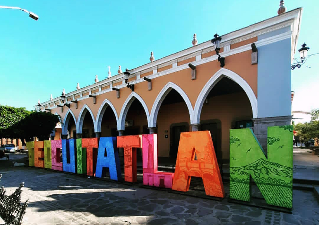
The arcades of the centre, with the colourful letters spelling the town's name.
The sanctuary and the Colegio Guadalupe.
The Hacienda de San José.
The hills Alameda, Colorado and Teocuitatlán, and the Atotonilco hot springs, in the municipality.
Plan your trip
Places to stay in Teocuitatlán de Corona
Compare hotels, posadas, and rentals in and around Teocuitatlán de Corona.
Tours & activities
Day trips and guided outings from Ajijic often include Teocuitatlán de Corona; with a local guide you can get there without a car.
Rental cars
Pick up a car at GDL (Guadalajara): about 39 min by road to Ajijic, then 26 km more to Teocuitatlán de Corona, on your own schedule.
Flights
The nearest airport with scheduled flights is Guadalajara (GDL), about 39 min by road from Ajijic, the base for Teocuitatlán de Corona.
Mobile data
Signal can drop away from Ajijic: download a map of the way to Teocuitatlán de Corona before you set out, or carry an eSIM with data.
Links open a partner site. We may earn a commission if you book, at no cost to you.
When to go to Teocuitatlán de Corona mild
Teocuitatlán de Corona shares the climate of Ajijic, 26 km away. The best months to visit are January, March, April, and November.
See the month-by-month climate of Ajijic
Weather in Teocuitatlán de Corona now and the next 7 days
Live forecast from Open-Meteo. Chance of rain is the day's highest.
The closest Pueblo Mágico: Ajijic

Ajijic is the Pueblo Mágico closest to Teocuitatlán de Corona, with places to stay, food, and more to see.
Also close to
- Sayula · Jalisco · 33 km away
- Mazamitla · Jalisco · 42 km away
- Tapalpa · Jalisco · 43 km away
- Cocula · Jalisco · 55 km away
- Tlaquepaque · Jalisco · 61 km away
Closest to Teocuitatlán de Corona
-
San Luis Soyatlán · Village · 14 km away
-
Atoyac · Town · 17 km away
-
Concepción de Buenos Aires · Town · 17 km away
-
Techaluta de Montenegro · Town · 18 km away
-
Tuxcueca · Village · 21 km away
-
Jocotepec · Town · 22 km away
-
San Juan Cosalá · Hot springs · 22 km away
-
Laguna de Sayula · Lake · 24 km away


Near Teocuitatlán de Corona


Drive times by road from OpenStreetMap, without traffic. Times marked ~ are estimated from the straight-line distance.
Location from OpenStreetMap. Written by Puebloteca.