Mountain Jocotitlán, Estado de México Municipality of Jocotitlán Northern Estado de México
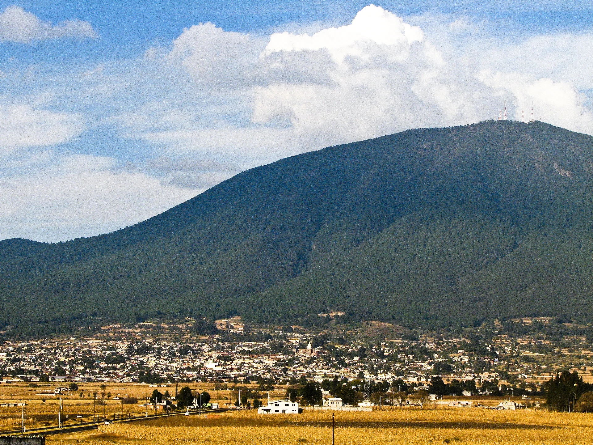
A 3,900 m volcano over the north of the Toluca valley: a Mazahua sacred mountain with a high chapel and an ecotourism park on its slopes.
From Toluca: 1 h 10 min by car (77 km by road) How to get there ↓
Near here
See everything nearby ↓


Plan your visit to Jocotitlán
Where to stay near Jocotitlán
Compare hotels, posadas and guest houses in Jocotitlán.
Tours to Jocotitlán
Day trips and guided outings from Villa del Carbón often include Jocotitlán; with a local guide you can get there without a car.
 Tours from Mexico City
Teotihuacan pyramids morning or afternoon without tourist traps
★ 4.9 (10,269) · From US$59
How to get to Jocotitlán
- From Toluca: about 1 h 10 min by road (~77 km)
- Nearest airport: Toluca (TLC), 1 h 12 min by car to Villa del Carbón
Links open a partner site. We may earn a commission if you book, at no cost to you.
Tours from Mexico City, near Jocotitlán


Tours, prices and ratings from Viator, checked weekly. We may earn a commission if you book.
About Jocotitlán
Jocotitlán is the dark, forested mountain that rises straight out of the farmland at the northern end of the Toluca valley, with the town of the same name spread along its foot. Locals also use its Nahuatl name, Xocotépetl, usually translated as "mountain of the sweet and sour fruits". It is a stratovolcano of the Trans-Mexican Volcanic Belt, built from layers of tephra and lava, and at roughly 3,900 m its summit ranks as the twelfth-highest peak in Mexico.
It is not extinct. The volcano has erupted at least twice in the past 10,000 years, and a chain of cinder cones just north of it shows how restless this ground is. Since 1975 its forests have been protected as the Isidro Fabela state park, which covers 3,701 hectares.
The Mazahua and Otomí peoples have long treated the mountain as holy. The Mazahua called it Nguemore, the sacred mountain; the Otomí knew it as Gumidi. Before the conquest a sanctuary to Otontecuhtli, the Otomí king of the gods, stood here. A Catholic chapel followed in the 1980s at about 3,670 m, probably one of the highest in the country, and on the first Sunday of every December the image of the Señor de la Expiración is carried in procession from the town's church of Jesús Nazareno up to a spot called La Virgen, in thanks for the harvest.
For visitors it is an unusually easy high mountain. A winding 19 km country lane climbs from town to the microwave antennas near the top, and on the slopes the Xocotépetl ecotourism park runs trails, mountain biking, a zip line, a hanging bridge and cabins. Cold fronts sometimes leave the summit white: on 11 December 2023 snow fell from about 3,700 m up.
How to get to Jocotitlán
Drive from Toluca: 1 h 10 min, 77 km
The way in is through the town of Jocotitlán, on the Toluca–Atlacomulco road (Highway 55, with the 55D toll section Toluca–Ixtlahuaca–Atlacomulco). From Toluca it is about 50 km and roughly 50 minutes; from Mexico City allow about two hours. At Jocotitlán leave the highway for the town centre and take Calle Benito Juárez; from town a winding country lane of about 19 km climbs to the antennas near the summit.
By public transport, Caminante runs buses about hourly from Mexico City's Terminal Poniente (Observatorio) to Atlacomulco, taking around 1 h 40 min; from Atlacomulco or Ixtlahuaca continue by taxi or local transport to Jocotitlán. To get up the mountain itself you need a car or a taxi.
El Oro, the nearest Pueblo Mágico by road, is about 46 km away via Atlacomulco (roughly 50 minutes); Villa del Carbón is about 50 km, close to an hour.
Directions to Jocotitlán on Google Maps
Distances are in a straight line; the road is usually longer.
Links open a partner site. We may earn a commission if you book, at no cost to you.
From the nearest cities to Jocotitlán
- Toluca · 77 km by road, 1 h 10 min
- San Juan del Río · 97 km by road, 1 h 40 min
- Ciudad Hidalgo · 118 km by road, 1 h 45 min
Drive times by road from OpenStreetMap, without traffic or stops. Times marked ~ are estimated from the straight-line distance.
Before you go to Jocotitlán: hours, prices and tips
- Hours
- The Xocotépetl ecotourism park opens Saturdays and Sundays, 10 am to 5 pm. Posta · checked Oct 2026
- Entry
- Entry to the park is free; activities carry a small fee from 25 pesos per person. Posta · checked Oct 2026
- Best season
- Winter cold fronts can bring snow to the summit (in December 2023 it snowed from 3,700 m up); the procession of the Señor de la Expiración is on the first Sunday of December. La Razón; Posta · checked Oct 2026
Hours and prices change, especially around holidays. Each fact links to where we checked it.
Visiting Jocotitlán: what to see and do
Drive or hike the 19 km lane from town to the antennas near the summit.
Visit the chapel at about 3,670 m, one of the highest in Mexico.
Spend a day at the Xocotépetl ecotourism park: trails, mountain biking, a zip line, a hanging bridge and cabins.
Join the procession of the Señor de la Expiración to La Virgen on the first Sunday of December.
In Jocotitlán town, see the parish church's 16th-century atrial cross and its one-piece stone font.
After a winter cold front, look for snow on the summit.
Plan your trip
Places to stay in Jocotitlán
Compare hotels, posadas, and rentals in and around Jocotitlán.
Tours & activities
Day trips and guided outings from Villa del Carbón often include Jocotitlán; with a local guide you can get there without a car.
Rental cars
Pick up a car at TLC (Toluca): about 1 h 12 min by road to Villa del Carbón, then 31 km more to Jocotitlán, on your own schedule.
Flights
The nearest airport with scheduled flights is Toluca (TLC), about 1 h 12 min by road from Villa del Carbón, the base for Jocotitlán.
Travel insurance
If you plan on hiking at altitude at Jocotitlán, check that your policy covers it: some plans leave adventure activities out.
Mobile data
Signal can drop away from Villa del Carbón: download a map of the way to Jocotitlán before you set out, or carry an eSIM with data.
Links open a partner site. We may earn a commission if you book, at no cost to you.
When to go to Jocotitlán cool
Jocotitlán shares the climate of Villa del Carbón, 31 km away. The best months to visit are January, February, March, and December.
For the clearest views from Jocotitlán, go in the driest months (January, February, March, and December); in the rains, clouds tend to build up by midday.
See the month-by-month climate of Villa del Carbón
Weather in Jocotitlán now and the next 7 days
Live forecast from Open-Meteo. Chance of rain is the day's highest.
The closest Pueblo Mágico: Villa del Carbón

Villa del Carbón is the Pueblo Mágico closest to Jocotitlán, with places to stay, food, and more to see.
Also close to
- Jilotepec · Estado de México · 33 km away
- El Oro · Estado de México · 39 km away
- Tlalpujahua · Michoacán · 44 km away
- Aculco · Estado de México · 44 km away
- Tepotzotlán · Estado de México · 56 km away
Closest to Jocotitlán
-
Ciudad de Jocotitlán · Town · 5 km away
-
San Bartolo Morelos · Village · 11 km away
-
Atlacomulco de Fabela · Town · 14 km away
-
San Andrés Timilpan · Town · 14 km away
-
Bioparque Estrella · Landmark · 17 km away
-
San Miguel Tenochtitlán · Village · 17 km away
-
San Felipe y Santiago · Village · 18 km away
-
San Francisco de Asís · Village · 18 km away

Near Jocotitlán




Drive times by road from OpenStreetMap, without traffic. Times marked ~ are estimated from the straight-line distance.
Lists with Jocotitlán
Mountains in Estado de México · 8 Mountains near Villa del Carbón · 8 Mountains near Jilotepec · 3 Mountains near Aculco · 3 Mountains near Toluca · 6 Mountains near Tepotzotlán · 13 Mountains near Metepec · 10Location from OpenStreetMap. Written by Puebloteca.