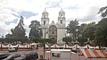

Town Ixtlahuaca, Estado de México Municipality of Ixtlahuaca Northern Estado de México
Mazahua-country seat with an 18th-century parish church, the spot where López Rayón was shot, and a big Monday tianguis.
From Toluca: 30 min by car (36 km by road) How to get there ↓
Near here
See everything nearby ↓



Plan your visit to Ixtlahuaca de Rayón
Where to stay near Ixtlahuaca de Rayón
Compare hotels, posadas and guest houses in Ixtlahuaca de Rayón.
Tours to Ixtlahuaca de Rayón
Day trips around Villa del Carbón sometimes stop in Ixtlahuaca de Rayón; a tour is the easy way to see it without a car.
 Tours from Mexico City
Teotihuacan pyramids morning or afternoon without tourist traps
★ 4.9 (10,269) · From US$59
How to get to Ixtlahuaca de Rayón
- From Toluca: about 30 min by road (~36 km)
- Nearest airport: Toluca (TLC), 1 h 12 min by car to Villa del Carbón
Links open a partner site. We may earn a commission if you book, at no cost to you.
Tours from Mexico City, near Ixtlahuaca de Rayón


Tours, prices and ratings from Viator, checked weekly. We may earn a commission if you book.
About Ixtlahuaca de Rayón
On the plain that separates the Toluca valley from the Mazahua lands to the north, at around 2,550 m, lies Ixtlahuaca de Rayón, seat of the municipality of Ixtlahuaca. It had 7,077 inhabitants in 2020; the municipality about 160,000. The Nahuatl name means "treeless plain"; the original Mazahua settlement, J'apui, lay some 4 km to the east, and the parish was built where the centre is now, blessed on 17 September 1552, the year viceroy Luis de Velasco granted it the status of a pueblo. Its position made it the obligatory pass towards Michoacán, Jalisco and Colima, and the Spanish made it the head town of the whole Mazahua district.
Independence is the history people remember here. Hidalgo came through with his army on 27 October 1810, on his way to Monte de las Cruces. Francisco López Rayón was captured in December 1815 on a road from the Real de El Oro and shot on 20 January 1816 at the south corner of what is now the municipal palace; in 1861 the state congress gave the town the title Villa de Ixtlahuaca de Rayón in his honour. The parish church of San Francisco de Asís was built between 1711 and 1735 with money from the Bachiller Andrés de Salvatierra, and its two towers dominate the square.
Mondays are what fill the town: that day's tianguis, which grew along with local trade, weighs heavily in the local economy, and there is also a municipal market and a bus terminal. The municipality also has Hacienda La Purísima, linked to the comedian Mario Moreno, Cantinflas.
How to get to Ixtlahuaca de Rayón
Drive from Toluca: 30 min, 36 km
By car from Toluca it is about 35 km (approx.) and 30 to 40 minutes on the Toluca-Ixtlahuaca-Atlacomulco toll road, the 55D; the 55D carries on to Atlacomulco, some 30 km north, approx.. From Ixtlahuaca, state road EM 3 heads to Naucalpan and federal highway 3 to San Felipe del Progreso. Starting in the capital, the whole trip takes about two hours (approx.): first to Toluca, then the 55D.
By bus there is no direct Toluca service in the route planners: what does show up is Flecha Roja from Observatorio in Mexico City, hourly and about 2 hours (approx.). Villa del Carbón is roughly 36 km away on the map and about 50 minutes by road (approx.). The town has its own bus terminal.
Directions to Ixtlahuaca de Rayón on Google Maps
Distances are in a straight line; the road is usually longer.
Links open a partner site. We may earn a commission if you book, at no cost to you.
From the nearest cities to Ixtlahuaca de Rayón
- Toluca · 36 km by road, 30 min
- Zitácuaro · 98 km by road, 1 h 15 min
- Mexico City · 102 km by road, 1 h 30 min
Drive times by road from OpenStreetMap, without traffic or stops. Times marked ~ are estimated from the straight-line distance.
Before you go to Ixtlahuaca de Rayón: hours, prices and tips
- Best time of day
- Come on a Monday, when the tianguis that has grown with local trade is set up. Wikipedia (es) · checked Oct 2026
Hours and prices change, especially around holidays. Each fact links to where we checked it.
Visiting Ixtlahuaca de Rayón: what to see and do
The parish church of San Francisco de Asís (1711-1735), with two towers facing the square.
The municipal palace, at whose south corner Francisco López Rayón was shot in 1816.
The Monday tianguis, the main trading day of the town.
The municipal market and the casa de cultura.
Hacienda La Purísima, linked to Cantinflas, in the municipality.
Plan your trip
Places to stay in Ixtlahuaca de Rayón
Compare hotels, posadas, and rentals in and around Ixtlahuaca de Rayón.
Tours & activities
Day trips around Villa del Carbón sometimes stop in Ixtlahuaca de Rayón; a tour is the easy way to see it without a car.
Rental cars
Pick up a car at TLC (Toluca): about 1 h 12 min by road to Villa del Carbón, then 36 km more to Ixtlahuaca de Rayón, on your own schedule.
Flights
The nearest airport with scheduled flights is Toluca (TLC), about 1 h 12 min by road from Villa del Carbón, the base for Ixtlahuaca de Rayón.
Mobile data
Signal can drop away from Villa del Carbón: download a map of the way to Ixtlahuaca de Rayón before you set out, or carry an eSIM with data.
Links open a partner site. We may earn a commission if you book, at no cost to you.
When to go to Ixtlahuaca de Rayón cool
Ixtlahuaca de Rayón shares the climate of Villa del Carbón, 36 km away. The best months to visit are January, February, March, and December.
See the month-by-month climate of Villa del Carbón
Weather in Ixtlahuaca de Rayón now and the next 7 days
Live forecast from Open-Meteo. Chance of rain is the day's highest.
The closest Pueblo Mágico: Villa del Carbón

Villa del Carbón is the Pueblo Mágico closest to Ixtlahuaca de Rayón, with places to stay, food, and more to see.
Also close to
- Metepec · Estado de México · 40 km away
- El Oro · Estado de México · 46 km away
- Jilotepec · Estado de México · 49 km away
- Tlalpujahua · Michoacán · 50 km away
- Angangueo · Michoacán · 55 km away
Closest to Ixtlahuaca de Rayón
-
San Francisco de Asís · Village · 2 km away
-
San Miguel Enyege · Village · 10 km away
-
San Felipe y Santiago · Village · 13 km away
-
Ciudad de Jocotitlán · Town · 16 km away
-
Jiquipilco · Town · 17 km away
-
San Bartolo Oxtotitlán · Village · 17 km away
-
Jocotitlán · Mountain · 19 km away
-
Temoaya · Village · 21 km away


Near Ixtlahuaca de Rayón


Drive times by road from OpenStreetMap, without traffic. Times marked ~ are estimated from the straight-line distance.
Location from OpenStreetMap. Written by Puebloteca.