Village Toluca, Estado de México Municipality of Toluca Toluca Valley
Toluca delegación below the Calixtlahuaca hill; three names, a legend of saints' images that kept returning to the church, and 6,250 people.
From Toluca: 10 min by car (7 km by road) How to get there ↓
Near here
See everything nearby ↓



Plan your visit to San Marcos Yachihuacaltepec
Where to stay near San Marcos Yachihuacaltepec
Compare hotels, posadas and guest houses in San Marcos Yachihuacaltepec.
Tours to San Marcos Yachihuacaltepec
Day trips and guided outings from Metepec often include San Marcos Yachihuacaltepec; with a local guide you can get there without a car.
 Tours from Mexico City
Teotihuacan pyramids morning or afternoon without tourist traps
★ 4.9 (10,269) · From US$59
How to get to San Marcos Yachihuacaltepec
- From Toluca: about 10 min by road (~7 km)
- Nearest airport: Toluca (TLC), 17 min by car to Metepec
Links open a partner site. We may earn a commission if you book, at no cost to you.
Tours from Mexico City, near San Marcos Yachihuacaltepec


Tours, prices and ratings from Viator, checked weekly. We may earn a commission if you book.
About San Marcos Yachihuacaltepec
This pueblo originario carries three names stacked on one another. The pre-Hispanic one, Xochihuacaltepec, may mean "those who own houses on the hill of flowers"; after the Conquest San Marcos Evangelista was added, and in 1986 Toluca's council tacked on Juan Aldama, after the insurgent. People just say San Marcos Yachihuacaltepec.
It lies about 8 km northwest of Toluca at 2,630 m, on a territory of only 1.89 km², and had 6,250 residents in 2020 (INEGI). It borders San Francisco de Asís Calixtlahuaca to the north, Santiago Tlaxomulco to the south, ejido land of Santa Cruz Atzcapotzaltongo to the east and, to the west, the Calixtlahuaca hill and La Teresona, described as a protected natural polygon.
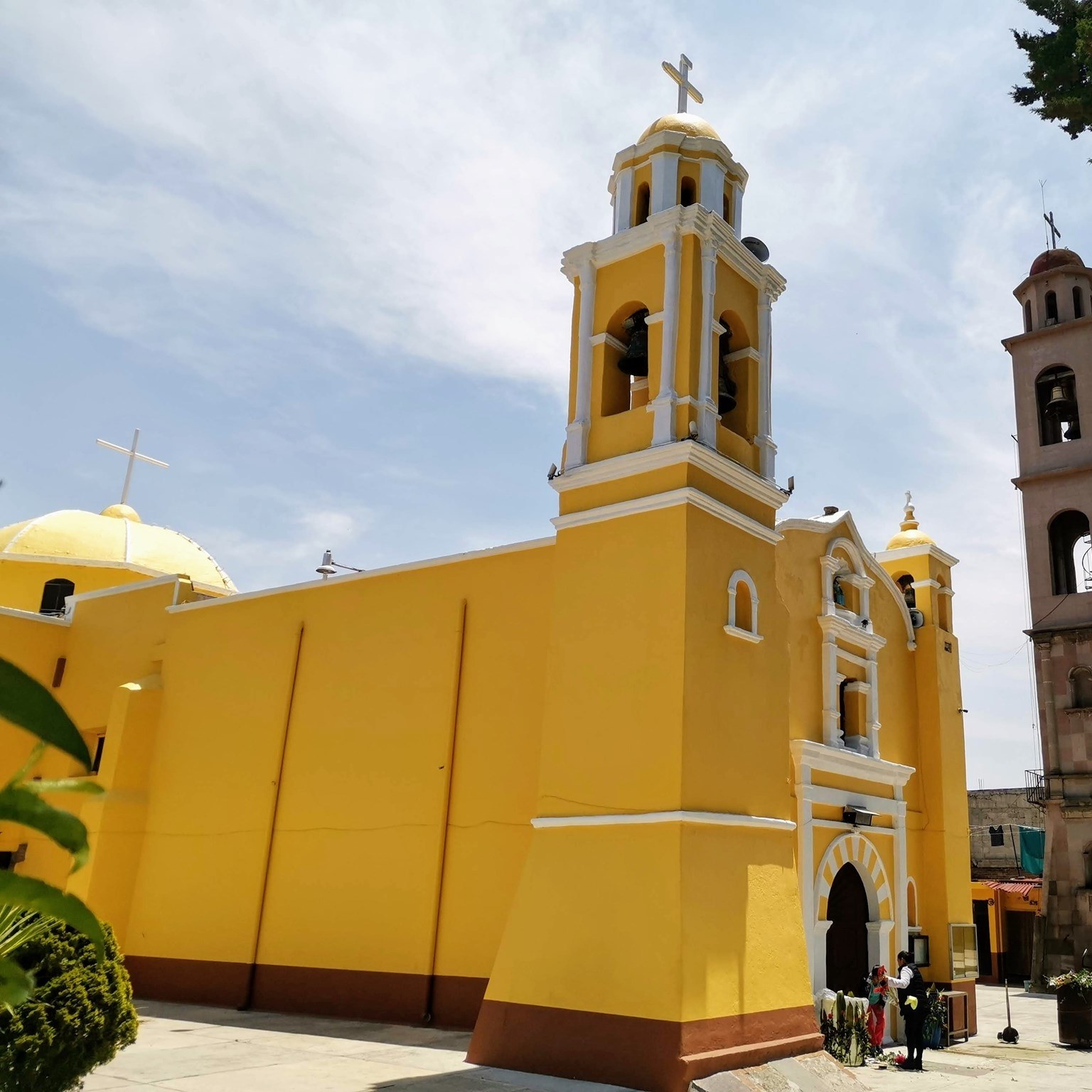
The local legend says images of the patron saints appeared on the spot where the church now stands; villagers carried them up to the hilltop, but they kept turning up in the temple, so the church was built there. The images said to be the ones found sit above the main door, facing the atrium. Today the village is a municipal delegation of Toluca.
How to get to San Marcos Yachihuacaltepec
Drive from Toluca: 10 min, 7 km
By bus from Toluca: the Xinantécatl line (Servicios Urbanos y Suburbanos Xinantécatl) starts at José María Heredia and Calzada al Pacífico (Centro Cultural) and ends at Miguel Hidalgo y Costilla: 17.7 km and about 59 minutes without traffic, roughly every 5 minutes, 14 pesos cash. It runs along Avenida Río Papaloapan, Isidro Fabela, Boulevard Solidaridad Las Torres and Boulevard Jesús Reyes Heroles. Other lines link it to Ciudad Universitaria (S T U T), San Felipe Tlalmimilolpan (Xinantécatl) and, on the Tollocan line, to Metepec and the Toluca 2000 industrial park (MisRutas data; check with the driver).
By car it is about 8 km northwest of Toluca (roughly 15 to 25 minutes) through the Calixtlahuaca area. From Mexico City, reach central Toluca on the México–Toluca highway (15D) or by the El Insurgente train from Observatorio. Metepec, the nearest pueblo, is about 12 km away in a straight line.
Directions to San Marcos Yachihuacaltepec on Google Maps
Distances are in a straight line; the road is usually longer.
Links open a partner site. We may earn a commission if you book, at no cost to you.
From the nearest cities to San Marcos Yachihuacaltepec
- Toluca · 7 km by road, 10 min
- Mexico City · 70 km by road, 1 h 10 min
- Zitácuaro · 88 km by road, 1 h 10 min
Drive times by road from OpenStreetMap, without traffic or stops. Times marked ~ are estimated from the straight-line distance.
Visiting San Marcos Yachihuacaltepec: what to see and do
Look at the yellow-fronted church and the saints' images above its main door, facing the atrium.
Recall in the atrium the legend of the images that kept returning to the church.
Head up toward the Calixtlahuaca hill, west of the village, and La Teresona.
Visit the Tecaxic-Calixtlahuaca archaeological zone in neighbouring Calixtlahuaca, 9 km north of Toluca.
Plan your trip
Places to stay in San Marcos Yachihuacaltepec
Compare hotels, posadas, and rentals in and around San Marcos Yachihuacaltepec.
Tours & activities
Day trips and guided outings from Metepec often include San Marcos Yachihuacaltepec; with a local guide you can get there without a car.
Rental cars
Pick up a car at TLC (Toluca): about 17 min by road to Metepec, then 12 km more to San Marcos Yachihuacaltepec, on your own schedule.
Flights
The nearest airport with scheduled flights is Toluca (TLC), about 17 min by road from Metepec, the base for San Marcos Yachihuacaltepec.
Mobile data
Signal can drop away from Metepec: download a map of the way to San Marcos Yachihuacaltepec before you set out, or carry an eSIM with data.
Links open a partner site. We may earn a commission if you book, at no cost to you.
When to go to San Marcos Yachihuacaltepec cool
San Marcos Yachihuacaltepec shares the climate of Metepec, 12 km away. The best months to visit are January, February, March, and December.
See the month-by-month climate of Metepec
Weather in San Marcos Yachihuacaltepec now and the next 7 days
Live forecast from Open-Meteo. Chance of rain is the day's highest.
The closest Pueblo Mágico: Metepec

Metepec is the Pueblo Mágico closest to San Marcos Yachihuacaltepec, with places to stay, food, and more to see.
Also close to
- Malinalco · Estado de México · 46 km away
- Villa del Carbón · Estado de México · 50 km away
- Valle de Bravo · Estado de México · 50 km away
- Ixtapan de la Sal · Estado de México · 53 km away
- Tonatico · Estado de México · 58 km away
Closest to San Marcos Yachihuacaltepec
-
Parque Estatal Sierra Morelos · Nature reserve · 2 km away
-
Zona Arqueológica de Calixtlahuaca · Archaeological site · 2 km away
-
San Mateo Oxtotitlán · Village · 3 km away
-
San Martín Toltepec · Village · 4 km away
-
San Antonio Buenavista · Village · 6 km away
-
Ex Convento de Zinacantepec · Landmark · 7 km away
-
Santa Ana Tlapaltitlán · Village · 7 km away
-
Cacalomacán · Town · 8 km away


Near San Marcos Yachihuacaltepec


Drive times by road from OpenStreetMap, without traffic. Times marked ~ are estimated from the straight-line distance.
Location from OpenStreetMap. Written by Puebloteca.