Landmark Pachuca de Soto, Hidalgo Municipality of Pachuca de Soto Hidalgo Mountain Corridor Comarca Minera Geopark
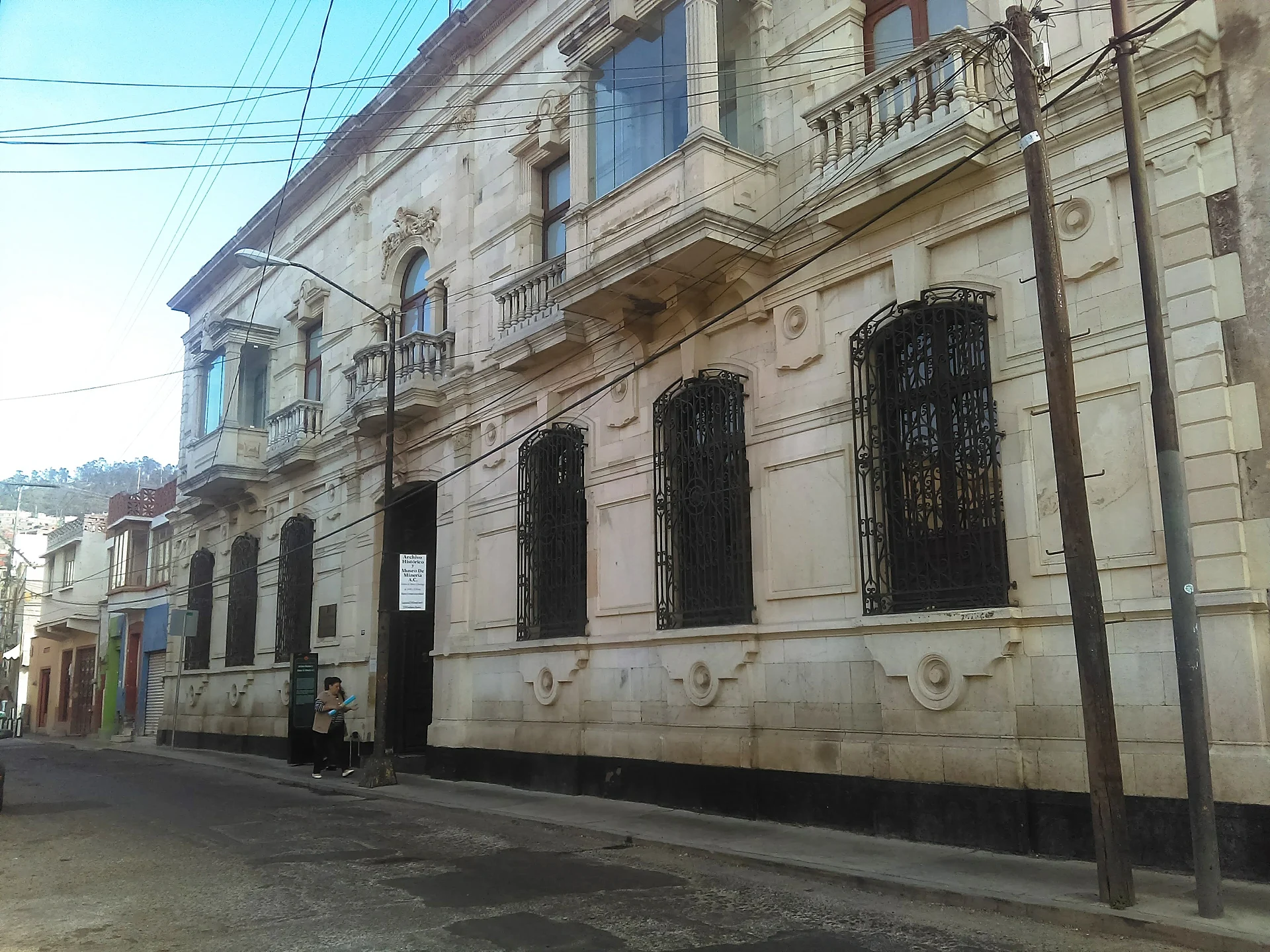
Silver-mining museum and archive in a neoclassical mansion on Calle Mina, with old 'cotorra' trucks and an 80-tonne crane in the garden.
From Tulancingo: about 45 min by road (~50 km) How to get there ↓
Near here
See everything nearby ↓


Plan your visit to Archivo Histórico y Museo de Minería de Pachuca
Where to stay near Archivo Histórico y Museo de Minería de Pachuca
Compare hotels, posadas and guest houses in Archivo Histórico y Museo de Minería de Pachuca.
Tours to Archivo Histórico y Museo de Minería de Pachuca
Look for tours of the area around Real del Monte that stop at Archivo Histórico y Museo de Minería de Pachuca.
 Tours from Zacatlan
Zacatlán Guided Tour walking through the Center
★ 5.0 (2) · From US$8
How to get to Archivo Histórico y Museo de Minería de Pachuca
- From Tulancingo: about 45 min by road (~50 km)
- Nearest airport: Mexico City (Felipe Ángeles) (NLU), 1 h 6 min by car to Real del Monte
Links open a partner site. We may earn a commission if you book, at no cost to you.
Tours from Zacatlan, near Archivo Histórico y Museo de Minería de Pachuca
Tours, prices and ratings from Viator, checked weekly. We may earn a commission if you book.
About Archivo Histórico y Museo de Minería de Pachuca
The Historic Archive and Mining Museum fills a two-storey 19th-century neoclassical mansion at Calle Francisco Javier Mina 110, right in central Pachuca. The building first housed the offices of the San Rafael y Anexas miners' cooperative; later it was a teacher-training college and a secondary school for workers over 15, then passed to the Hidalgo state government and finally to the Real del Monte y Pachuca mining company, which donated it to the museum. Its quarry-stone walls enclose about 950 m² arranged around a central patio and two gardens, behind a symmetrical facade with wrought-iron grilles, balconies on corbels and fluted Doric pilasters at the corners.
Rescue of the mining company's papers began in 1981, the archive was formally set up in 1987 and the museum opened on 1 June 1993. A visit starts with a roughly 15-minute film in which miners describe their own work, moves into a geology room with 3D models, then climbs to the upper floor for pre-Hispanic metalworking, colonial-era mining and the English adventurers who arrived in 1824. The main gallery covers the American-run years, when the Pachuca–Real del Monte district became the world's top silver producer, and the later state-owned period, through tools, plans, photographs of men underground and original equipment. Out in the garden, an industrial-archaeology yard holds early 20th-century Mack trucks nicknamed cotorras ('parrots'), which hauled gold and silver bars to the railway wagons, plus an 80-tonne crane and a mine winch.
The archive keeps records from 1727 to 2002 in six collections: colonial (including papers on the 1766 miners' strike), 19th century, American, state-owned, subsidiary companies and graphic, the last with negatives, prints, maps, posters and video. It is regarded as Mexico's most complete specialised mining archive, with two reading rooms: the Juan Barrón library of about 7,200 volumes and the Ezequiel Ordóñez periodicals library of about 13,000. The same institution also runs the Acosta and La Dificultad mine site museums and an occupational-medicine museum in Real del Monte, so this mansion makes a good primer before you go down a real shaft.
How to get to Archivo Histórico y Museo de Minería de Pachuca
The mansion is at Calle Mina 110, some 300 metres south-east of the Reloj Monumental clock tower on Plaza Independencia, a five-minute stroll. Drivers coming up from the capital use the Mexico–Pachuca toll road. Without a car, head for Mexico City's northern bus station (Terminal Central de Autobuses del Norte), where ADO runs direct buses every 30 minutes and Futura every 20, for a journey of roughly 1 h 45 min. Pachuca's own terminal is well outside the centre; a cab or combi drops you nearby. On the Tuzobús rapid-bus line, get off at Niños Héroes, the stop nearest the museum. By road, Tulancingo lies 45 minutes off (47 km) and Real del Monte, where the same institution runs its mine museums, 10 minutes (9 km).
Directions to Archivo Histórico y Museo de Minería de Pachuca on Google Maps
Distances are in a straight line; the road is usually longer.
Links open a partner site. We may earn a commission if you book, at no cost to you.
From the nearest cities to Archivo Histórico y Museo de Minería de Pachuca
- Tulancingo · about 50 km by road, ~45 min
- Huauchinango · about 90 km by road, ~1 h 20 min
- Mexico City · about 115 km by road, ~1 h 40 min
Drive times by road from OpenStreetMap, without traffic or stops. Times marked ~ are estimated from the straight-line distance.
Before you go to Archivo Histórico y Museo de Minería de Pachuca: hours, prices and tips
- Hours
- Tuesday to Friday, 10:00 to 17:00 (sources disagree on weekends; check before you go). Tus Buenas Noticias · checked Oct 2026
- Entry
- 50 pesos. Tus Buenas Noticias · checked Oct 2026
- Time needed
- The introductory film runs about 15 minutes before you tour the rooms. Wikipedia · checked Oct 2026
Hours and prices change, especially around holidays. Each fact links to where we checked it.
Visiting Archivo Histórico y Museo de Minería de Pachuca: what to see and do
The miners' film that opens the visit.
The geology room with its 3D models.
The upstairs rooms on pre-Hispanic metalworking, colonial mining and the English era.
The main gallery on the American and state-owned periods.
The Mack 'cotorra' trucks, 80-tonne crane and mine winch in the garden.
The neoclassical facade with its balconies and ironwork on Calle Mina.
Plan your trip
Places to stay in Archivo Histórico y Museo de Minería de Pachuca
Compare hotels, posadas, and rentals in and around Archivo Histórico y Museo de Minería de Pachuca.
Tours & activities
Look for tours of the area around Real del Monte that stop at Archivo Histórico y Museo de Minería de Pachuca.
Rental cars
Pick up a car at NLU (Mexico City (Felipe Ángeles)): about 1 h 6 min by road to Real del Monte, then 6 km more to Archivo Histórico y Museo de Minería de Pachuca, on your own schedule.
Flights
The nearest airport with scheduled flights is Mexico City (Felipe Ángeles) (NLU), about 1 h 6 min by road from Real del Monte, the base for Archivo Histórico y Museo de Minería de Pachuca.
Mobile data
Signal can drop away from Real del Monte: download a map of the way to Archivo Histórico y Museo de Minería de Pachuca before you set out, or carry an eSIM with data.
Links open a partner site. We may earn a commission if you book, at no cost to you.
When to go to Archivo Histórico y Museo de Minería de Pachuca cool
Archivo Histórico y Museo de Minería de Pachuca shares the climate of Real del Monte, 6 km away. The best months to visit are February, March, April, and May.
See the month-by-month climate of Real del Monte
Weather in Archivo Histórico y Museo de Minería de Pachuca now and the next 7 days
Live forecast from Open-Meteo. Chance of rain is the day's highest.
The closest Pueblo Mágico: Real del Monte

Real del Monte is the Pueblo Mágico closest to Archivo Histórico y Museo de Minería de Pachuca, with places to stay, food, and more to see.
Also close to
- Mineral del Chico · Hidalgo · 9 km away
- Huasca de Ocampo · Hidalgo · 17 km away
- Zempoala · Hidalgo · 24 km away
- Otumba · Estado de México · 48 km away
- Teotihuacán · Estado de México · 50 km away
Closest to Archivo Histórico y Museo de Minería de Pachuca
-
Jardín de los Niños Héroes · Nature reserve · 0 km away
-
Templo y exconvento de San Francisco de Pachuca · Landmark · 0 km away
-
Basílica Menor de Nuestra Señora de Guadalupe · Landmark · 1 km away
-
Cristo Rey · Viewpoint · 1 km away
-
El Arbolito · Landmark · 1 km away
-
Jardín del Maestro · Nature reserve · 1 km away
-
Pachuca · City · 1 km away
-
Parque Hidalgo · Nature reserve · 1 km away


Near Archivo Histórico y Museo de Minería de Pachuca



Drive times by road from OpenStreetMap, without traffic. Times marked ~ are estimated from the straight-line distance.
Location from OpenStreetMap. Written by Puebloteca.