Landmark Pachuca de Soto, Hidalgo Municipality of Pachuca de Soto Hidalgo Mountain Corridor Comarca Minera Geopark
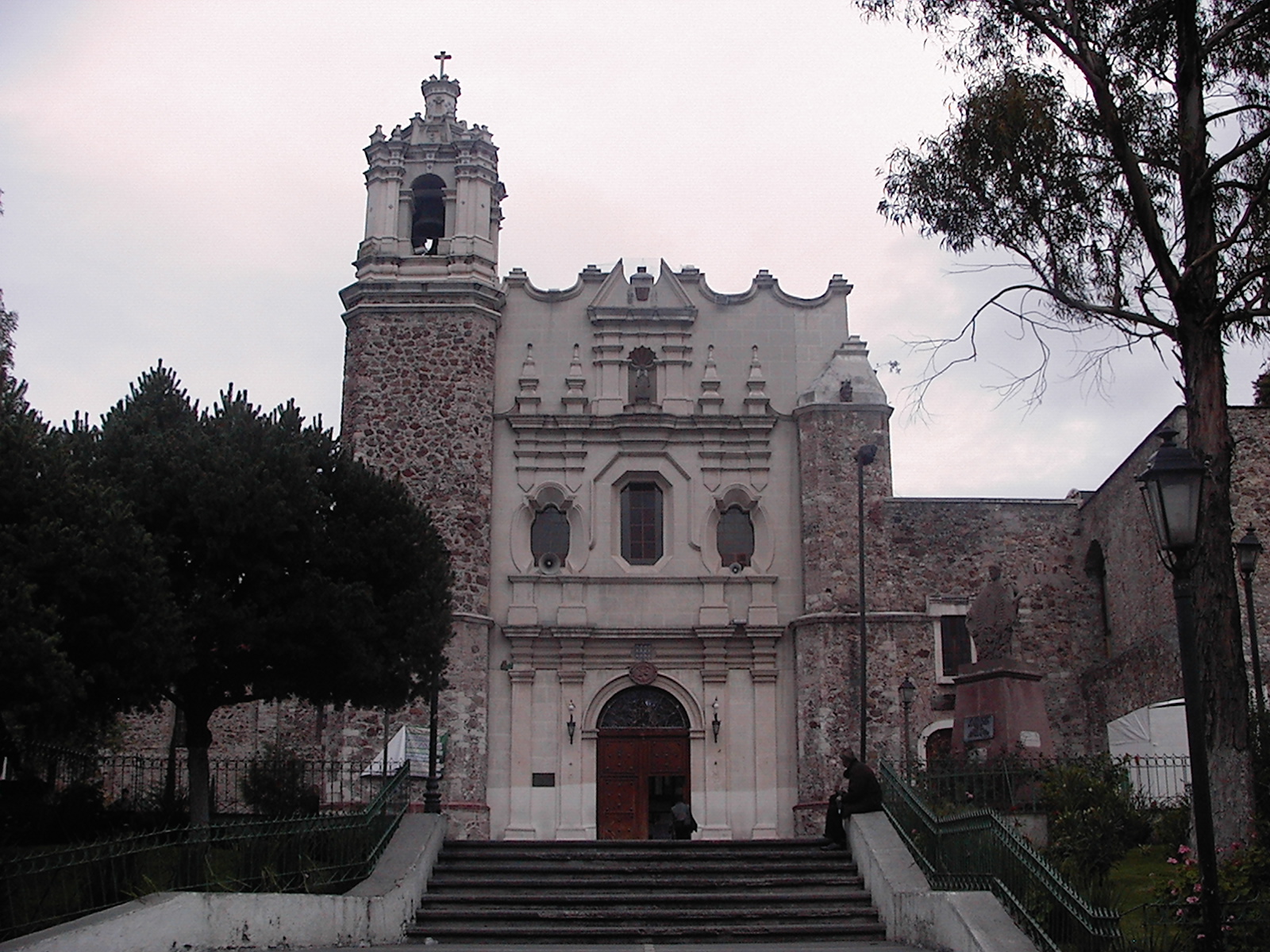
Franciscan church founded in 1596 whose old convent now holds Mexico's national photo archive, a free photography museum and an arts centre.
From Tulancingo: about 45 min by road (~50 km) How to get there ↓
Near here
See everything nearby ↓


Plan your visit to Templo y exconvento de San Francisco de Pachuca
Where to stay near Templo y exconvento de San Francisco de Pachuca
Compare hotels, posadas and guest houses in Templo y exconvento de San Francisco de Pachuca.
Tours to Templo y exconvento de San Francisco de Pachuca
Look for tours of the area around Real del Monte that stop at Templo y exconvento de San Francisco de Pachuca.
 Tours from Zacatlan
Zacatlán Guided Tour walking through the Center
★ 5.0 (2) · From US$8
How to get to Templo y exconvento de San Francisco de Pachuca
- From Tulancingo: about 45 min by road (~50 km)
- Nearest airport: Mexico City (Felipe Ángeles) (NLU), 1 h 6 min by car to Real del Monte
Links open a partner site. We may earn a commission if you book, at no cost to you.
Tours from Zacatlan, near Templo y exconvento de San Francisco de Pachuca
Tours, prices and ratings from Viator, checked weekly. We may earn a commission if you book.
About Templo y exconvento de San Francisco de Pachuca
The church of San Francisco de Asís and its former convent make up one of the largest building complexes in central Pachuca. Friar Francisco de Torantos founded the Franciscan house in 1596, funded mostly by miners' alms, with 18,000 pesos for the church from Beatriz de Miranda. The first cloister was done by 1604 and the church around 1660. In 1732 the convent became a Propaganda Fide missionary college, and in 1771 silver magnate Pedro Romero de Terreros, Count of Regla, paid for a refectory, kitchen, infirmary, library, cells and orchards. The Reform Laws expelled the friars in 1860–1861, and the buildings went on to serve as a jail, barracks, civil hospital and mining school; in 1882 part of the old orchards became Parque Hidalgo. In January 1924 a dynamite bomb blew out the doors and organ and toppled a tower, which is why the tympanum carries both 1596 and 1924.
The church is Baroque with touches of Churrigueresque and Neoclassical, faces west and has a cross-shaped plan, groin vaults, four Neoclassical side altars, a wooden pulpit and a lantern-topped dome. The octagonal sacristy holds oil paintings of the life of St Francis, and in the transept lies the incorrupt body locals call Santa Columba, a catacomb saint given by Micaela Romero de Terreros. Alongside are the Third Order chapel, with an 1897 marble font and stained glass, and the chapel of Nuestra Señora de la Luz from around 1734. Each October the church anchors Pachuca's traditional San Francisco fair, which gets going around the 4th.
The old convent is now a cultural hub. INAH's Fototeca Nacional, the national photo archive set up in 1978 around the Casasola collection, holds some 900,000 pieces in 46 collections dating from 1847, and its photography museum shows them in five sections (portrait, testimony, daily life, landscape and visual essay), from the camera obscura to work by Hugo Brehme, Guillermo Kahlo and Manuel Álvarez Bravo. Other cloisters hold the site museum, with about 50 mostly 18th-century pieces from the college years; the Antonio Peñafiel library; the Cuartel del Arte gallery, which has shown Rivera, Tamayo, Varo and Dalí; and the Centro de las Artes de Hidalgo, for dance, theatre, music, printmaking and writing, whose lobby has a 200 m² mural by Roberto Cueva del Río (1956–1957) on the state's history.
How to get to Templo y exconvento de San Francisco de Pachuca
The church and cloisters line the southern edge of the old centre, facing Plaza Aniceto Ortega between Calle Casasola and Jardín Colón. Starting at the Reloj Monumental, walk about 800 metres due south, roughly ten minutes. From the capital the quickest route is the toll highway into Hidalgo. On public transport, Futura departs every half hour from Indios Verdes, the last stop on Metrobús line 1, while both ADO and Futura connect Felipe Ángeles airport (AIFA) with Pachuca in about an hour and a half. Coaches pull into the terminal at the old Coscotitlán hacienda; for the centre, catch a cab or combi, or the Tuzobús, whose trunk line ends in the north at the Centro Histórico stop. Driving, Tulancingo is 45 minutes away (46 km), with Real del Monte only 15 (11 km).
Directions to Templo y exconvento de San Francisco de Pachuca on Google Maps
Distances are in a straight line; the road is usually longer.
Links open a partner site. We may earn a commission if you book, at no cost to you.
From the nearest cities to Templo y exconvento de San Francisco de Pachuca
- Tulancingo · about 50 km by road, ~45 min
- Huauchinango · about 90 km by road, ~1 h 20 min
- Mexico City · about 115 km by road, ~1 h 40 min
Drive times by road from OpenStreetMap, without traffic or stops. Times marked ~ are estimated from the straight-line distance.
Before you go to Templo y exconvento de San Francisco de Pachuca: hours, prices and tips
- Hours
- Photography museum: Tuesday to Sunday, 10:00 to 17:00. INAH · checked Oct 2026
- Entry
- Free entry to the photography museum; professional cameras pay a separate fee. INAH · checked Oct 2026
- Best season
- Traditional San Francisco fair every October, from around the 4th. Wikipedia · checked Oct 2026
- Guide or tour
- The museum offers guided tours; they are optional. Tours: Viator GetYourGuide INAH · checked Oct 2026
- Rules
- No smoking, food, pets or flash photography in the museum. INAH · checked Oct 2026
Hours and prices change, especially around holidays. Each fact links to where we checked it.
Visiting Templo y exconvento de San Francisco de Pachuca: what to see and do
The facade dated 1596 and 1924, with St Francis in his niche.
The incorrupt body of Santa Columba in the transept.
The octagonal sacristy with its paintings of St Francis's life.
The chapels of Nuestra Señora de la Luz and the Third Order.
The free photography museum of the Fototeca Nacional.
The site museum with pieces from the missionary-college years.
Roberto Cueva del Río's mural in the Centro de las Artes.
The Cuartel del Arte gallery in pink and white stone.
The white-stone clock in Jardín Colón and nearby Parque Hidalgo.
Plan your trip
Places to stay in Templo y exconvento de San Francisco de Pachuca
Compare hotels, posadas, and rentals in and around Templo y exconvento de San Francisco de Pachuca.
Tours & activities
Look for tours of the area around Real del Monte that stop at Templo y exconvento de San Francisco de Pachuca.
Rental cars
Pick up a car at NLU (Mexico City (Felipe Ángeles)): about 1 h 6 min by road to Real del Monte, then 7 km more to Templo y exconvento de San Francisco de Pachuca, on your own schedule.
Flights
The nearest airport with scheduled flights is Mexico City (Felipe Ángeles) (NLU), about 1 h 6 min by road from Real del Monte, the base for Templo y exconvento de San Francisco de Pachuca.
Mobile data
Signal can drop away from Real del Monte: download a map of the way to Templo y exconvento de San Francisco de Pachuca before you set out, or carry an eSIM with data.
Links open a partner site. We may earn a commission if you book, at no cost to you.
When to go to Templo y exconvento de San Francisco de Pachuca cool
Templo y exconvento de San Francisco de Pachuca shares the climate of Real del Monte, 7 km away. The best months to visit are February, March, April, and May.
See the month-by-month climate of Real del Monte
Weather in Templo y exconvento de San Francisco de Pachuca now and the next 7 days
Live forecast from Open-Meteo. Chance of rain is the day's highest.
The closest Pueblo Mágico: Real del Monte

Real del Monte is the Pueblo Mágico closest to Templo y exconvento de San Francisco de Pachuca, with places to stay, food, and more to see.
Also close to
- Mineral del Chico · Hidalgo · 9 km away
- Huasca de Ocampo · Hidalgo · 17 km away
- Zempoala · Hidalgo · 24 km away
- Otumba · Estado de México · 47 km away
- Teotihuacán · Estado de México · 49 km away
Closest to Templo y exconvento de San Francisco de Pachuca
-
Archivo Histórico y Museo de Minería de Pachuca · Landmark · 0 km away
-
Jardín de los Niños Héroes · Nature reserve · 0 km away
-
Parque Hidalgo · Nature reserve · 0 km away
-
Basílica Menor de Nuestra Señora de Guadalupe · Landmark · 1 km away
-
Cristo Rey · Viewpoint · 1 km away
-
Jardín del Maestro · Nature reserve · 1 km away
-
Pachuca · City · 1 km away
-
Parque de la Familia · Nature reserve · 1 km away


Near Templo y exconvento de San Francisco de Pachuca


Drive times by road from OpenStreetMap, without traffic. Times marked ~ are estimated from the straight-line distance.
Location from OpenStreetMap. Written by Puebloteca.