
Village Tlacotepec de Benito Juárez, Puebla Municipality of Tlacotepec de Benito Juárez Tehuacán Valley
Tlacotepec village where palm hats are woven, with a carnival of two rival barrios and the Immaculate Conception feast on 8 December.
From Tehuacán: 40 min by car (37 km by road) How to get there ↓
Near here
See everything nearby ↓


Plan your visit to Santa María la Alta
Where to stay near Santa María la Alta
Compare hotels, posadas and guest houses in Santa María la Alta.
Tours to Santa María la Alta
Day trips and guided outings from Orizaba often include Santa María la Alta; with a local guide you can get there without a car.
 Tours from Puebla City
Africam Safari Zoo Admission with Transportation
★ 4.8 (87) · From US$35
How to get to Santa María la Alta
- From Tehuacán: about 40 min by road (~37 km)
- Nearest airport: Veracruz (VER), 1 h 42 min by car to Orizaba
Links open a partner site. We may earn a commission if you book, at no cost to you.
Tours from Puebla City, near Santa María la Alta


Tours, prices and ratings from Viator, checked weekly. We may earn a commission if you book.
About Santa María la Alta
Santa María la Alta's carnival is a contest: for three to five days in February or March, costumed men and boys dance through the streets in two camps, the barrenquero and the barrio macho, tied to the barrios of San Francisco and San Mateo, and on the last day the side that gathered more participants is counted the winner. This auxiliary town of Tlacotepec de Benito Juárez, in southeastern Puebla and within Tehuacán's orbit, counted 7,812 residents in the 2020 census and sits at 1,952 m, close to the Santo Nombre archaeological zone.
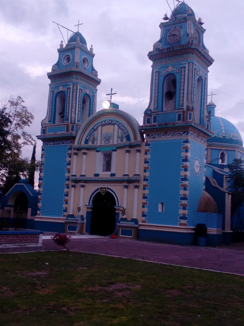
The town is split into four barrios, Santa Rosa, San Mateo, San Francisco and Santa Teresa, each with its own feast date; the celebration that brings them all together is that of the Immaculate Conception of Mary every 8 December, with processions, dances, flower arrangements and fireworks. The photo shows the church dedicated to her. For the Day of the Dead families build altars and decorate graves with flowers. Many people make a living from trade, carrying goods to states across the country, and Nahuatl is also heard among residents.
Santa María la Alta is the place in the municipality where making hats and other palm goods is customary; ribbon, feathers, henequen and plastic are worked too, and many pieces end up as decorations in the town's own fiestas. The municipality, about 400 km², is mostly semi-dry and temperate, averaging 12 to 18 °C with 400 to 800 mm of rain, and nearly half its land is farmed while another 39% is scrub. Local food includes mole poblano, barbacoa and tlacoyos, pitaya and xoconoxtle sweets, and pulque. In the seat, Tlacotepec, there is a 16th-century Holy Cross church and a house on Avenida Juárez that served Benito Juárez as an office for three days.
How to get to Santa María la Alta
Drive from Tehuacán: 40 min, 37 km
It lies about 103 km by road from Puebla city (76 km in a straight line) and about 38 km from Tehuacán, the nearest large city (32 km as the crow flies). The practical approach is to reach Tehuacán or Tlacotepec first and continue on local transport; Mexico City is roughly 225 km away.
Directions to Santa María la Alta on Google Maps
Distances are in a straight line; the road is usually longer.
Links open a partner site. We may earn a commission if you book, at no cost to you.
From the nearest cities to Santa María la Alta
- Tehuacán · 37 km by road, 40 min
- Orizaba · 93 km by road, 1 h 35 min
- Puebla · 105 km by road, 1 h 35 min
Drive times by road from OpenStreetMap, without traffic or stops. Times marked ~ are estimated from the straight-line distance.
Visiting Santa María la Alta: what to see and do
The Immaculate Conception church and its 8 December feast.
The San Francisco versus San Mateo carnival, in February or March.
Palm hats and other palm work made in town.
The nearby Santo Nombre archaeological zone.
In Tlacotepec, the Holy Cross church and the house Juárez used.
Plan your trip
Places to stay in Santa María la Alta
Compare hotels, posadas, and rentals in and around Santa María la Alta.
Tours & activities
Day trips and guided outings from Orizaba often include Santa María la Alta; with a local guide you can get there without a car.
Rental cars
Pick up a car at VER (Veracruz): about 1 h 42 min by road to Orizaba, then 64 km more to Santa María la Alta, on your own schedule.
Flights
The nearest airport with scheduled flights is Veracruz (VER), about 1 h 42 min by road from Orizaba, the base for Santa María la Alta.
Mobile data
Signal can drop away from Orizaba: download a map of the way to Santa María la Alta before you set out, or carry an eSIM with data.
Links open a partner site. We may earn a commission if you book, at no cost to you.
When to go to Santa María la Alta mild
Santa María la Alta shares the climate of Orizaba, 64 km away. The best months to visit are February, March, April, and December.
See the month-by-month climate of Orizaba
Weather in Santa María la Alta now and the next 7 days
Live forecast from Open-Meteo. Chance of rain is the day's highest.
The closest Pueblo Mágico: Orizaba

Orizaba is the Pueblo Mágico closest to Santa María la Alta, with places to stay, food, and more to see.
Also close to
- Ixtenco · Tlaxcala · 78 km away
Closest to Santa María la Alta
-
Tlacotepec de Benito Juárez · Village · 9 km away
-
San Luis Temalacayuca · Village · 10 km away
-
San Marcos Tlacoyalco · Village · 10 km away
-
Tepanco de López · Village · 11 km away
-
Tepazolco · Village · 12 km away
-
Atenayuca · Village · 13 km away
-
San Miguel Zozutla · Village · 17 km away
-
Xochitlán Todos Santos · Village · 17 km away
Near Santa María la Alta




Drive times by road from OpenStreetMap, without traffic. Times marked ~ are estimated from the straight-line distance.
Location from OpenStreetMap. Written by Puebloteca.