Town Tamuín, San Luis Potosí Municipality of Tamuín Huasteca Potosina
Huastec town on the Tampaón River, base for the Tamtoc and Tamohi archaeological sites and the Taninul sulphur springs.
From Ciudad Valles: about 30 min by road (~30 km) How to get there ↓
Near here
See everything nearby ↓



Plan your visit to Tamuín
Where to stay near Tamuín
Compare hotels, posadas and guest houses in Tamuín.
Tours to Tamuín
Day trips around Aquismón sometimes stop in Tamuín; a tour is the easy way to see it without a car.
 Tours from Ciudad Valles
Rafting in Tampaon River from Ciudad Valles
★ 5.0 (845) · From US$115
How to get to Tamuín
- From Ciudad Valles: about 30 min by road (~30 km)
- Nearest airport: Tampico (TAM), 2 h 49 min by car to Aquismón
Links open a partner site. We may earn a commission if you book, at no cost to you.
Tours from Ciudad Valles, near Tamuín


Tours, prices and ratings from Viator, checked weekly. We may earn a commission if you book.
About Tamuín
Tamuín is the seat of its municipality on the flat eastern lowlands of the Huasteca Potosina, about 20 metres above sea level, with around 16,600 residents. The Tampaón River runs through the municipality and, downstream, meets the Moctezuma to become the Pánuco, which flows on to Tampico and the Gulf. The name has been spelled many ways over the centuries (Tamuche, Tam-Ohin, Tamuyn, Tamohi), and nobody agrees on its meaning either: place of the catán fish, place of mosquitoes, or place of the book of knowledge.
The first Spanish land grant in the Potosí Huasteca was made here, and by 1585 Tamuín had a Franciscan guardian, which means it had a friary. In 1831 an army engineer steamed up the Pánuco from Tampico all the way to Tamuín, the first steamboat locals had ever seen. The old village, El Choyal, stood further south; today's town was laid out in 1892 at La Cofradía on land carved from the El Limón hacienda.
The town now lives on cattle and industry: meat packers, a cement works, two power stations and the Nestlé powdered-milk plant opened in the 1960s. Visitors come for what lies around it: the Huastec archaeological sites of Tamtoc and Tamohi (El Consuelo), the Sierra del Abra-Tanchipa, a biosphere reserve since 1994, and the sulphur-spring baths at Taninul near the Ciudad Valles line. Local cooking means catán, a gar-like river fish from the Tampaón, alongside Huastec cecina and enchiladas, washed down with jobo-fruit wine.
How to get to Tamuín
Tamuín sits on federal highway 70, the road from Ciudad Valles to Ébano and Tampico, which doubles as the town's main street; since 2012 the Valles-Tamuín bypass skirts central Valles. From Ciudad Valles it is 35 min and 31 km by road; from Aquismón, the nearest Pueblo Mágico, 1 h and 66 km. Buses leave Ciudad Valles hourly for the roughly 45-minute ride; Transportes Vencedor's station is by the municipal market on Av. Gral. Pedro Antonio de los Santos. The archaeological sites are well outside town and far from each other, so take a taxi or hire one for a few hours.
Directions to Tamuín on Google Maps
Distances are in a straight line; the road is usually longer.
Links open a partner site. We may earn a commission if you book, at no cost to you.
From the nearest cities to Tamuín
- Ciudad Valles · about 30 km by road, ~30 min
- Ciudad Mante · about 110 km by road, ~1 h 35 min
- Tampico · about 125 km by road, ~1 h 55 min
Drive times by road from OpenStreetMap, without traffic or stops. Times marked ~ are estimated from the straight-line distance.
Before you go to Tamuín: hours, prices and tips
- Best season
- The town's main popular festivities fall in Holy Week. Enciclopedia de los Municipios de México (INAFED) · checked Oct 2026
Hours and prices change, especially around holidays. Each fact links to where we checked it.
Visiting Tamuín: what to see and do
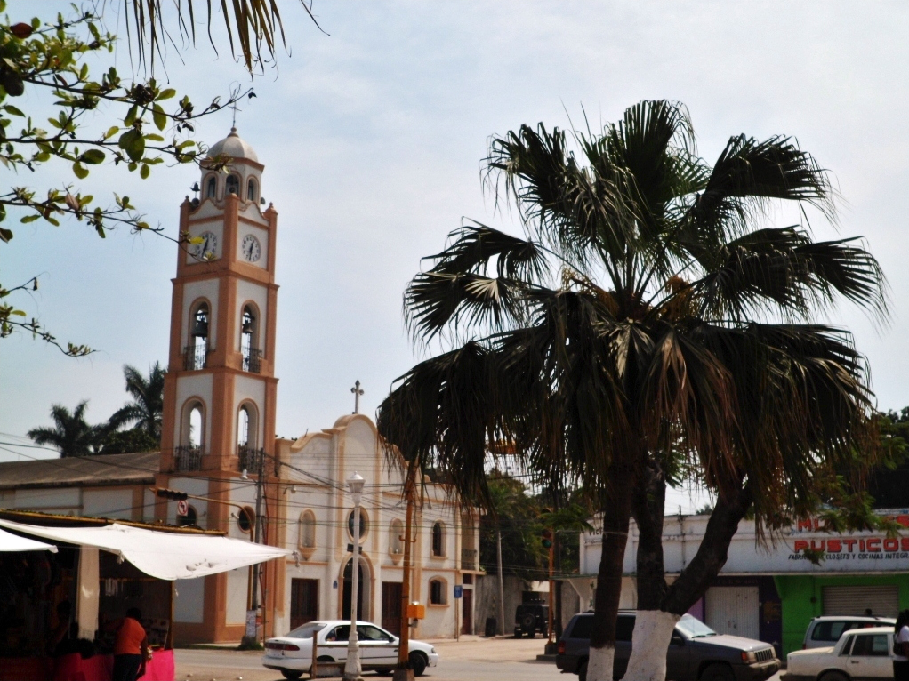
The Church of the Immaculate Conception in the centre
The Tamohi (El Consuelo) archaeological site, south of town by the road to San Vicente Tancuayalab
The Tamtoc archaeological site, between Taninul and the Tampaón River
The Taninul sulphur-spring baths
The Tampaón River and the Sierra del Abra-Tanchipa
Catán river fish in the town's restaurants
Plan your trip
Places to stay in Tamuín
Compare hotels, posadas, and rentals in and around Tamuín.
Tours & activities
Day trips around Aquismón sometimes stop in Tamuín; a tour is the easy way to see it without a car.
Rental cars
Pick up a car at TAM (Tampico): about 2 h 49 min by road to Aquismón, then 49 km more to Tamuín, on your own schedule.
Flights
The nearest airport with scheduled flights is Tampico (TAM), about 2 h 49 min by road from Aquismón, the base for Tamuín.
Mobile data
Signal can drop away from Aquismón: download a map of the way to Tamuín before you set out, or carry an eSIM with data.
Links open a partner site. We may earn a commission if you book, at no cost to you.
When to go to Tamuín warm
Tamuín shares the climate of Aquismón, 49 km away. The best months to visit are January, February, March, and December.
See the month-by-month climate of Aquismón
Weather in Tamuín now and the next 7 days
Live forecast from Open-Meteo. Chance of rain is the day's highest.
The closest Pueblo Mágico: Aquismón

Aquismón is the Pueblo Mágico closest to Tamuín, with places to stay, food, and more to see.
Also close to
- Xilitla · San Luis Potosí · 72 km away
Closest to Tamuín
-
Zona Arqueológica Tamohi · Archaeological site · 7 km away
-
Zona Arqueológica de Tamtoc · Archaeological site · 10 km away
-
Ciudad Valles · City · 25 km away
-
San Vicente Tancuayalab · Town · 38 km away
-
Cascadas de Micos · Waterfall · 40 km away
-
Cascadas de Tambaque · Waterfall · 45 km away
-
Cueva del Agua · Cave · 46 km away
-
Cascada de Tamul · Waterfall · 47 km away

Near Tamuín






Drive times by road from OpenStreetMap, without traffic. Times marked ~ are estimated from the straight-line distance.
Location from OpenStreetMap. Written by Puebloteca.