Village Tlaxco, Tlaxcala Municipality of Tlaxco
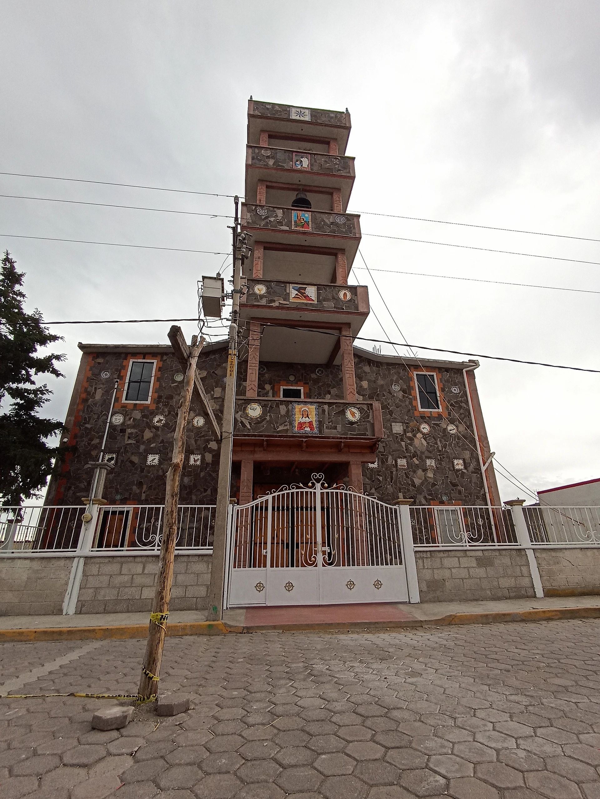
Hamlet of 640 people at 2,519 m in western Tlaxco, with a church whose stepped tower is clad in stone and tile images.
From Chiautempan: 40 min by car (41 km by road) How to get there ↓
Near here
See everything nearby ↓


Plan your visit to La Magdalena Soltepec
Where to stay near La Magdalena Soltepec
Compare hotels, posadas and guest houses in La Magdalena Soltepec.
Tours to La Magdalena Soltepec
Day trips and guided outings from Tlaxco often include La Magdalena Soltepec; with a local guide you can get there without a car.
 Tours from Zacatlan
Zacatlán Guided Tour walking through the Center
★ 5.0 (2) · From US$8
How to get to La Magdalena Soltepec
- From Chiautempan: about 40 min by road (~41 km)
- Nearest airport: Puebla (PBC), 1 h 6 min by car to Tlaxco
Links open a partner site. We may earn a commission if you book, at no cost to you.
Tours from Zacatlan, near La Magdalena Soltepec
Tours, prices and ratings from Viator, checked weekly. We may earn a commission if you book.
About La Magdalena Soltepec
La Magdalena Soltepec lies in the western part of Tlaxco municipality, at 2,519 metres above sea level and about 21 km in a straight line from the town of Tlaxco. The 2020 census counted 640 people in 150 homes, up from 584 in 2010, and nearly every home has electricity and piped water. The climate is highland: a mean of 13.5 °C, winter frosts (the lowest reading since 1970 was -4.5 °C in February 1976) and about 666 mm of rain a year, with June the wettest month.
The church is what stands out. A front-on photo on Wikimedia Commons shows a five-tier tower that narrows toward the top, walls of irregular flagstone combined with reddish brick, a balcony at every level and small tile images, among them a female figure above the main door, set in a churchyard with a white railing and a street paved in hexagonal cobbles. Its look is very different from the colonial churches of Tlaxco town.
The village sits in the Soltepec area, a name shared by neighbouring settlements: San Lorenzo Soltepec is about 2.8 km west and Cerro Soltepec, 2,874 metres high, rises 5.7 km to the north. Larger neighbouring communities include José María Morelos Buenavista, 4.4 km south, San José Tepeyahualco, 5.1 km southwest, and Ignacio Zaragoza, 7 km north. There are no hotels or tourist services in the village; visitors tend to pass through between these communities or come to see the church.
How to get to La Magdalena Soltepec
Drive from Chiautempan: 40 min, 41 km
La Magdalena Soltepec is about 21 km in a straight line west of Tlaxco, the municipal seat and Pueblo Mágico. From Mexico City there is a direct bus from TAPO to the Tlaxco station with Autotransportes Tlaxcala, Apizaco, Huamantla (ATAH), about 2 h 30 min according to Rome2rio; from Apizaco, Autobuses Teotihuacan covers the leg to Tlaxco every hour in about 25 minutes. From Tlaxco you continue west on local roads to the village; there are no published schedules for public transport straight there, so ask in town for a taxi or colectivo, or drive. The neighbouring communities of San Lorenzo Soltepec and José María Morelos Buenavista are under 5 km away in a straight line.
Directions to La Magdalena Soltepec on Google Maps
Distances are in a straight line; the road is usually longer.
Links open a partner site. We may earn a commission if you book, at no cost to you.
From the nearest cities to La Magdalena Soltepec
- Chiautempan · 41 km by road, 40 min
- San Martín Texmelucan · 50 km by road, 55 min
- Huamantla · 63 km by road, 55 min
Drive times by road from OpenStreetMap, without traffic or stops. Times marked ~ are estimated from the straight-line distance.
Visiting La Magdalena Soltepec: what to see and do
The village church, with its stepped tower of stone and tile images.
The streets paved in hexagonal cobbles around the churchyard.
Cerro Soltepec (2,874 m), 5.7 km to the north, as a landmark of the landscape.
San Lorenzo Soltepec, 2.8 km west, to visit both communities in one trip.
Plan your trip
Places to stay in La Magdalena Soltepec
Compare hotels, posadas, and rentals in and around La Magdalena Soltepec.
Tours & activities
Day trips and guided outings from Tlaxco often include La Magdalena Soltepec; with a local guide you can get there without a car.
Rental cars
Pick up a car at PBC (Puebla): about 1 h 6 min by road to Tlaxco, then 21 km more to La Magdalena Soltepec, on your own schedule.
Flights
The nearest airport with scheduled flights is Puebla (PBC), about 1 h 6 min by road from Tlaxco, the base for La Magdalena Soltepec.
Mobile data
Signal can drop away from Tlaxco: download a map of the way to La Magdalena Soltepec before you set out, or carry an eSIM with data.
Links open a partner site. We may earn a commission if you book, at no cost to you.
When to go to La Magdalena Soltepec cool
La Magdalena Soltepec shares the climate of Tlaxco, 21 km away. The best months to visit are January, February, November, and December.
See the month-by-month climate of Tlaxco
Weather in La Magdalena Soltepec now and the next 7 days
Live forecast from Open-Meteo. Chance of rain is the day's highest.
The closest Pueblo Mágico: Tlaxco

Tlaxco is the Pueblo Mágico closest to La Magdalena Soltepec, with places to stay, food, and more to see.
Also close to
- Chignahuapan · Puebla · 41 km away
- Otumba · Estado de México · 48 km away
- Huejotzingo · Puebla · 48 km away
- Huamantla · Tlaxcala · 51 km away
- Zempoala · Hidalgo · 53 km away
Closest to La Magdalena Soltepec
-
Presa El Muerto · Lake · 2 km away
-
San Lorenzo Soltepec · Village · 3 km away
-
José María Morelos Buenavista · Village · 5 km away
-
San José Tepeyahualco · Village · 5 km away
-
Ignacio Zaragoza · Village · 7 km away
-
Lagunilla · Village · 8 km away
-
Mazaquiáhuac · Village · 8 km away
-
Mariano Matamoros · Village · 9 km away


Near La Magdalena Soltepec


Drive times by road from OpenStreetMap, without traffic. Times marked ~ are estimated from the straight-line distance.
Location from OpenStreetMap. Written by Puebloteca.