Town Cuautepec de Hinojosa, Hidalgo Municipality of Cuautepec de Hinojosa
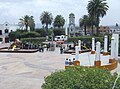
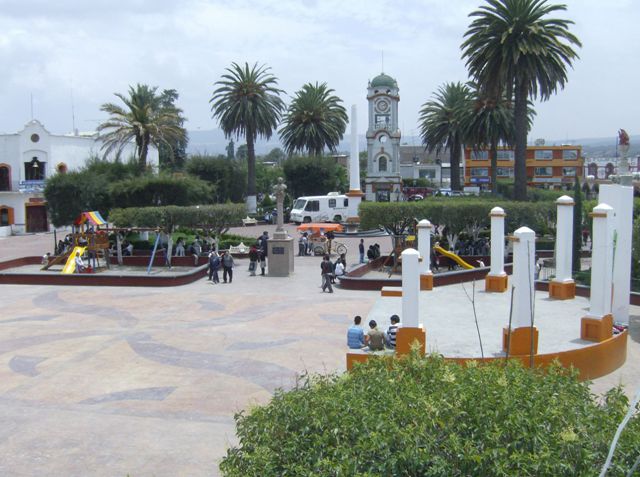
Municipal seat next to Tulancingo, with a clock tower on Jardín Felipe Ángeles and the pollo al disco with gualumbos that won it a Pueblo con Sabor seal.
From Tulancingo: 10 min by car (8 km by road) How to get there ↓
Near here


Plan your visit to Cuautepec de Hinojosa
Where to stay near Cuautepec de Hinojosa
Compare hotels, posadas and guest houses in Cuautepec de Hinojosa.
Tours to Cuautepec de Hinojosa
Day trips around Acaxochitlán sometimes stop in Cuautepec de Hinojosa; a tour is the easy way to see it without a car.
How to get to Cuautepec de Hinojosa
- From Tulancingo: about 10 min by road (~8 km)
- Nearest airport: Poza Rica (PAZ), 1 h 41 min by car to Acaxochitlán
Links open a partner site. We may earn a commission if you book, at no cost to you.
About Cuautepec de Hinojosa
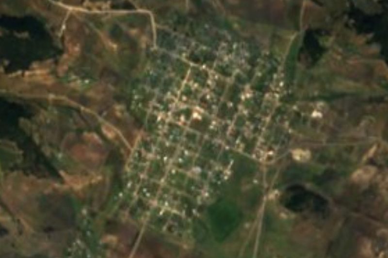
Cuautepec is usually translated as "wooded hill", from cuauh, tree, and tepetl, hill, but there is a twist: the Diccionario del náhuatl en el español de México notes that colonial and 19th-century documents call the town Coatepec, "hill of the snakes", and that the spelling Cuautepec first turned up in Hidalgo's 1870 electoral law, perhaps a clerk's slip. "De Hinojosa" was added in honour of Pedro de Hinojosa. The town sits at 2,241 metres among low hills and plains with a cool temperate climate, about 15 °C on average, and had 20,530 residents in 2020.
The centre revolves around Jardín Felipe Ángeles, with its Monumental Clock, and the parish church of San Antonio de Padua. Beyond town the municipality is large and varied: the lagoon and old hacienda of San Juan Hueyapan, the hills of El Yolo and Los Ermitaños, the El Campanario eco-park in Tezoncualpan and part of the Tecocomulco lagoon, where people fish. Further back rise the Coatzetzengo volcano and Cerro La Manilla, both 2,930 metres. Barley is the main crop, ahead of maize and oats, and local trades include jewellery, metalwork and textiles; there are three municipal street markets.
In the kitchen, Cuautepec earned its Pueblo con Sabor seal with pollo al disco con gualumbos, chicken cooked on a disc with gualumbos. The dish was born in Santa Elena Paliseca more than four decades ago, when young men coming home from a dance cooked on a griddle set over three stones and a wood fire; today it is also made with pork chop, steak or minced meat, and outside gualumbo season with peas, corn, broad beans or mushrooms, plus beer and tequila. The local table adds frog mixiotes in green sauce, trout in xoconostle sauce, turkey and barbacoa.
How to get to Cuautepec de Hinojosa
Drive from Tulancingo: 10 min, 8 km
Cuautepec is right next to Tulancingo: about 8 km by road and under 10 minutes by car or taxi. Tulancingo has two bus stations, first and second class, with lines from Mexico City and other cities, so the practical option is to get there and continue by taxi or local transport. From Mexico City by car it is about 124 km, roughly 1 h 50 min; Autobuses Teotihuacan also runs a few daily services to Cuautepec from the Ecatepec area. Acaxochitlán, the nearest Pueblo Mágico, is about 18 km away as the crow flies.
Directions to Cuautepec de Hinojosa on Google Maps
Distances are in a straight line; the road is usually longer.
Links open a partner site. We may earn a commission if you book, at no cost to you.
From the nearest cities to Cuautepec de Hinojosa
- Tulancingo · 8 km by road, 10 min
- Huauchinango · 48 km by road, 50 min
- Pachuca · 54 km by road, 55 min
Drive times by road from OpenStreetMap, without traffic or stops. Times marked ~ are estimated from the straight-line distance.
Map of Cuautepec de Hinojosa
Neighbourhoods and villages of Cuautepec de Hinojosa
Part of Cuautepec de Hinojosa or just outside it, closest first.
-
El Tepeyac · Village · 1 km from the centre
A locality of 1,702 people at 2,264 m, just north of Cuautepec, with a Nahuatl name meaning "hill with a nose". -
Almoloya · Village · 2 km from the centre
A locality of 3,010 people 2 km from Cuautepec in the Tulancingo Valley; its name means place where the spring wells up. -
Tezoquipa · Village · 3 km from the centre
Hill-country village at 2,220 m, 2.4 km west of Cuautepec de Hinojosa and almost touching Ventoquipa, in the Tulancingo valley. -
Ventoquipa · Village · 3 km from the centre
Tulancingo valley village at 2,212 m, with a railway station that starts a tourist route in Santiago Tulantepec.
Day trips and tours from Cuautepec de Hinojosa
The closest Pueblos Mágicos and places to visit, with the drive from Cuautepec de Hinojosa and tours that leave from it.


Times marked ~ are estimated from the distance. Links open a partner site. We may earn a commission if you book, at no cost to you.
Before you go: getting to and around Cuautepec de Hinojosa
- The nearest airport is Poza Rica (PAZ).
- The best months to go are February, March, April, and May.
- Everything on this page is in or close to the centre: walk, or take a short taxi ride.
- For day trips a rental car gives the most freedom; the tours above leave from Cuautepec de Hinojosa.
Before you go to Cuautepec de Hinojosa: hours, prices and tips
- Best time of day
- Criterio Hidalgo recommends visiting in the December holiday season. Criterio Hidalgo · checked Oct 2026
Hours and prices change, especially around holidays. Each fact links to where we checked it.
Visiting Cuautepec de Hinojosa: what to see and do
Jardín Felipe Ángeles and the Monumental Clock, downtown
Parish church of San Antonio de Padua
The lagoon and old hacienda of San Juan Hueyapan
El Yolo and Los Ermitaños hills, at Las Palmas and Puerta del Yolo
El Campanario eco-park in Tezoncualpan
Pollo al disco with gualumbos, the dish from Santa Elena Paliseca
Plan your trip
Places to stay in Cuautepec de Hinojosa
Compare hotels, posadas, and rentals in and around Cuautepec de Hinojosa.
Tours & activities
Day trips around Acaxochitlán sometimes stop in Cuautepec de Hinojosa; a tour is the easy way to see it without a car.
Rental cars
Pick up a car at PAZ (Poza Rica): about 1 h 41 min by road to Acaxochitlán, then 18 km more to Cuautepec de Hinojosa, on your own schedule.
Flights
The nearest airport with scheduled flights is Poza Rica (PAZ), about 1 h 41 min by road from Acaxochitlán, the base for Cuautepec de Hinojosa.
Mobile data
Signal can drop away from Acaxochitlán: download a map of the way to Cuautepec de Hinojosa before you set out, or carry an eSIM with data.
Links open a partner site. We may earn a commission if you book, at no cost to you.
When to go to Cuautepec de Hinojosa cool
Cuautepec de Hinojosa shares the climate of Acaxochitlán, 18 km away. The best months to visit are February, March, April, and May.
See the month-by-month climate of Acaxochitlán
Weather in Cuautepec de Hinojosa now and the next 7 days
Live forecast from Open-Meteo. Chance of rain is the day's highest.
The closest Pueblo Mágico: Acaxochitlán

Acaxochitlán is the Pueblo Mágico closest to Cuautepec de Hinojosa, with places to stay, food, and more to see.
Also close to
- Huauchinango · Puebla · 31 km away
- Pahuatlán · Puebla · 32 km away
- Huasca de Ocampo · Hidalgo · 35 km away
- Chignahuapan · Puebla · 37 km away
- Zacatlán · Puebla · 39 km away
Near Cuautepec de Hinojosa




Drive times by road from OpenStreetMap, without traffic. Times marked ~ are estimated from the straight-line distance.
Location from OpenStreetMap. Written by Puebloteca.