Landmark Teziutlán, Puebla Sierra Norte de Puebla
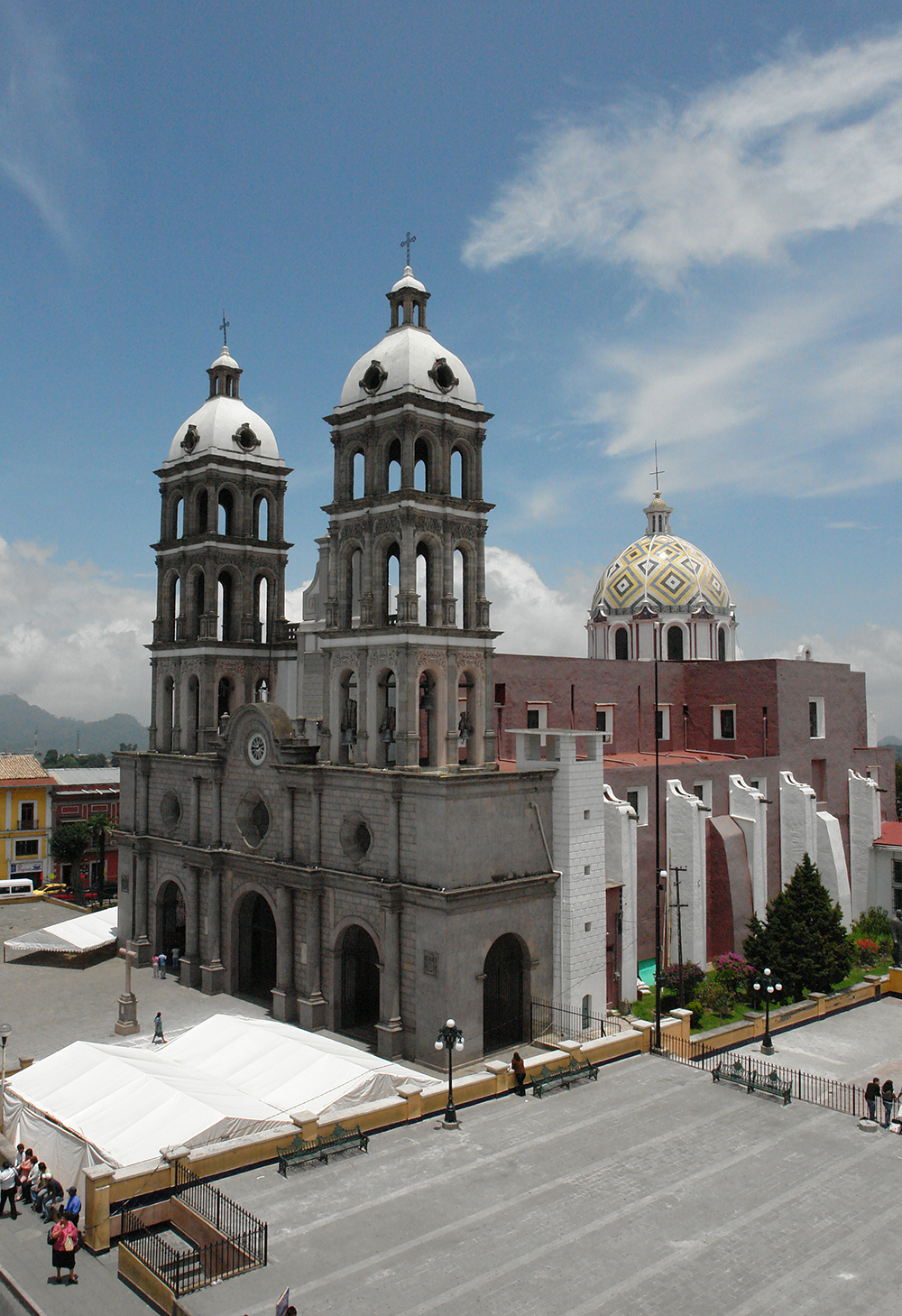
The Assumption cathedral in central Teziutlán, its façade built from 4,388 blocks of pink Xaltipan stone and finished in 1954.
From Martínez de la Torre: about 50 min by road (~55 km) How to get there ↓
Near here
See everything nearby ↓



Plan your visit to Catedral de Teziutlán
Where to stay near Catedral de Teziutlán
Compare hotels, posadas and guest houses in Catedral de Teziutlán.
Tours to Catedral de Teziutlán
Look for tours of the area around Teziutlán that stop at Catedral de Teziutlán.
How to get to Catedral de Teziutlán
- From Martínez de la Torre: about 50 min by road (~55 km)
- Nearest airport: Poza Rica (PAZ), 2 h 14 min by car to Teziutlán
Links open a partner site. We may earn a commission if you book, at no cost to you.
About Catedral de Teziutlán
The Cathedral of Santa María de la Asunción stands on the corner of Avenida Hidalgo and Calle Allende in the very centre of Teziutlán, the city in Puebla's northeastern highlands that was named a Pueblo Mágico in June 2023. Teziutlán sits at roughly 1,940 metres, had 62,849 residents in 2020 and bills itself as the foggiest city in Mexico, so the towers are often wrapped in mist.
The church began as a hermitage of Saint Michael the Archangel, then became the parish of the Assumption and later the Rosary chapel. On 19 March 1819, during the feast of Saint Joseph, the city's second patron, a fire destroyed almost the whole building; only the sagrario (the Blessed Sacrament chapel) and the Rosary chapel survived. In 1821 the parish priest Manuel Ignacio Vázquez rebuilt it in timber, with no towers attached to the nave; the bells hung in a separate belfry at the southwest corner of the forecourt.
On 19 June 1931 the parish was raised to cathedral when the seat of the Diocese of Papantla moved from Veracruz to Teziutlán, and Nicolás Corona became the first bishop to govern from here. The diocese still carries Papantla's name. In 1941 the great bell was cast: about four tonnes, named Santa María de la Asunción and blessed on 8 August that year.
What you see from the square today dates from the 1950s. Work on the façade began in 1952 and ended on 30 April 1954, using 4,388 blocks of pink cantera stone quarried at Xaltipan, under engineers Eduardo Acevedo and Daniel Rodríguez with stonemasons Ricardo Medina and Ambrosio Méndez. The design blends Romanesque, Baroque and Neoclassical touches: heavy piers with Ionic columns framing stained-glass windows, a clock on the front, two three-tier towers, eight bells in all, and a hemispherical dome raised on an octagonal drum. Inside, the focus is the image of the Virgin of the Assumption, the city's patron, whose feast falls in August.
How to get to Catedral de Teziutlán
The cathedral is in the middle of Teziutlán, so reaching the city means reaching the church: it sits on the corner of Avenida Hidalgo and Allende, facing the main square. By car from Puebla city it is about 146 km and just over two hours: leave through Amozoc onto the Amozoc–Perote toll road (129D/140D), then take the Libres–Teziutlán highway up into the sierra. From Martínez de la Torre on the Veracruz side it is about 54 km and 50 minutes, and from Huauchinango about 105 km and 1 hour 35 minutes. By bus, ADO runs frequent departures from Puebla's CAPU terminal (Vía also serves the route), taking about two and a half hours; from Mexico City, ADO leaves the TAPO terminal a few times a day for a ride of about four hours. From Teziutlán's bus station, take a taxi to the centre.
Directions to Catedral de Teziutlán on Google Maps
Distances are in a straight line; the road is usually longer.
Links open a partner site. We may earn a commission if you book, at no cost to you.
From the nearest cities to Catedral de Teziutlán
- Martínez de la Torre · about 55 km by road, ~50 min
- Xalapa · about 75 km by road, ~1 h 5 min
- Papantla · about 90 km by road, ~1 h 20 min
Drive times by road from OpenStreetMap, without traffic or stops. Times marked ~ are estimated from the straight-line distance.
Before you go to Catedral de Teziutlán: hours, prices and tips
- Hours
- Open every day. Wikipedia · checked Oct 2026
- Best season
- The feast of the Virgin of the Assumption, the city's patron, is held in August. Programa Destinos México · checked Oct 2026
Hours and prices change, especially around holidays. Each fact links to where we checked it.
Visiting Catedral de Teziutlán: what to see and do
The pink Xaltipan stone façade, finished in 1954.
The two three-tier towers and the clock on the front.
The hemispherical dome on its octagonal drum.
The image of the Virgin of the Assumption, Teziutlán's patron.
The stained-glass windows framed by Ionic columns.
The square in front of the forecourt, at Hidalgo and Allende.
Plan your trip
Places to stay in Catedral de Teziutlán
Compare hotels, posadas, and rentals in and around Catedral de Teziutlán.
Tours & activities
Look for tours of the area around Teziutlán that stop at Catedral de Teziutlán.
Rental cars
Pick up a car at PAZ (Poza Rica): about 2 h 14 min by road to Teziutlán, then 4 km more to Catedral de Teziutlán, on your own schedule.
Flights
The nearest airport with scheduled flights is Poza Rica (PAZ), about 2 h 14 min by road from Teziutlán, the base for Catedral de Teziutlán.
Mobile data
Signal can drop away from Teziutlán: download a map of the way to Catedral de Teziutlán before you set out, or carry an eSIM with data.
Links open a partner site. We may earn a commission if you book, at no cost to you.
When to go to Catedral de Teziutlán cool
Catedral de Teziutlán shares the climate of Teziutlán, 4 km away. The best months to visit are February, March, April, and November.
See the month-by-month climate of Teziutlán
Weather in Catedral de Teziutlán now and the next 7 days
Live forecast from Open-Meteo. Chance of rain is the day's highest.
The closest Pueblo Mágico: Teziutlán

Teziutlán is the Pueblo Mágico closest to Catedral de Teziutlán, with places to stay, food, and more to see.
Also close to
- Tlatlauquitepec · Puebla · 15 km away
- Cuetzalan · Puebla · 28 km away
- Zozocolco · Veracruz · 43 km away
- Tetela de Ocampo · Puebla · 47 km away
- Naolinco · Veracruz · 54 km away
Closest to Catedral de Teziutlán
-
Manantiales de Chignautla · Nature reserve · 3 km away
-
San José · Village · 3 km away
-
San Juan Xiutetelco · Archaeological site · 4 km away
-
Santiago · Village · 4 km away
-
Sosa · Village · 4 km away
-
Coahuixco · Village · 5 km away
-
Mexcalcuautla · Village · 6 km away
-
San Francisco · Village · 6 km away
Near Catedral de Teziutlán





Drive times by road from OpenStreetMap, without traffic. Times marked ~ are estimated from the straight-line distance.
Location from OpenStreetMap. Written by Puebloteca.