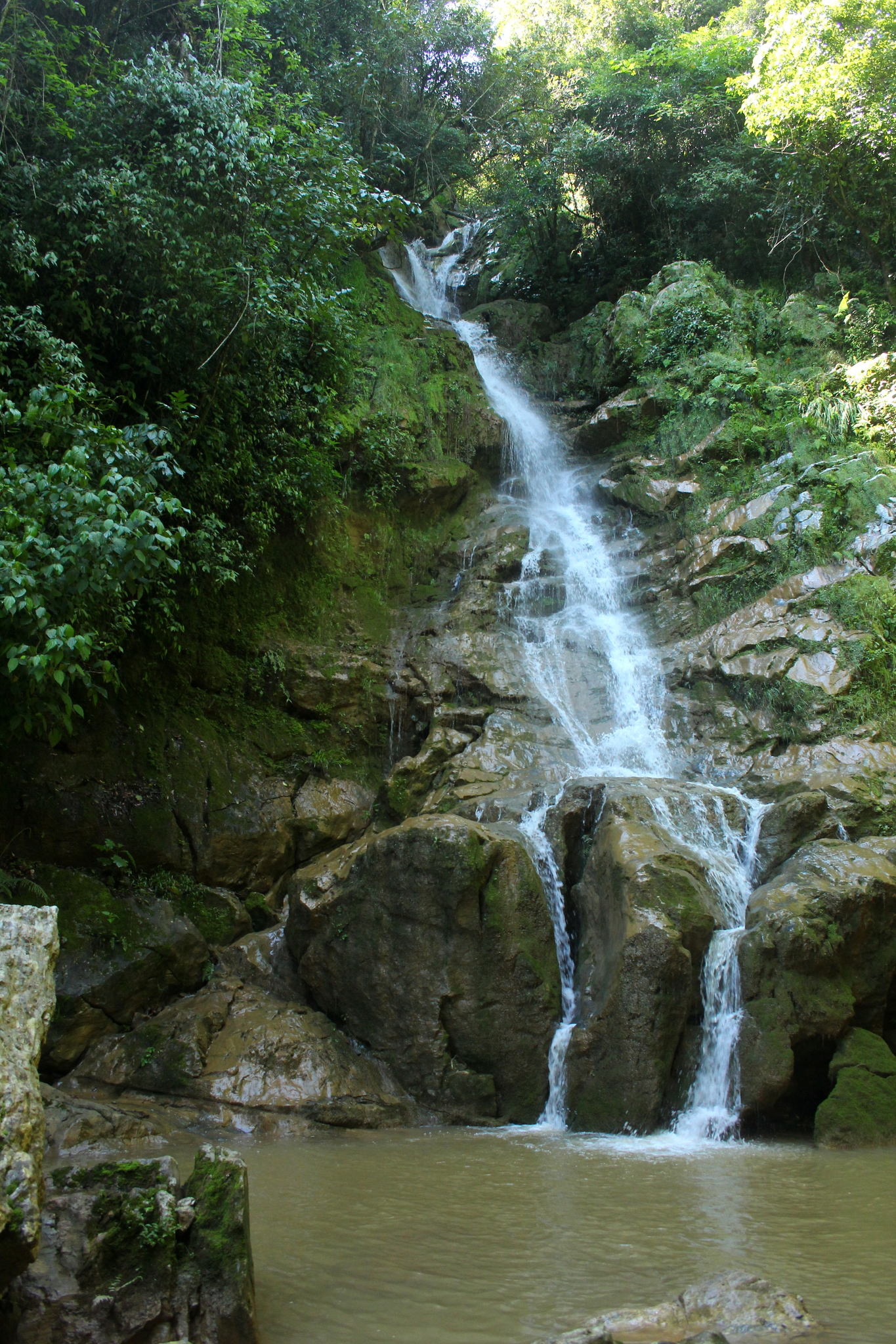
Waterfall Oaxaca La Cañada (Oaxaca)
A waterfall in thick green forest about 10 minutes from Huautla on the road to Chilchotla, with clear water and spots for rappelling.
From Tehuacán: 1 h 55 min by car (123 km by road) How to get there ↓
Near here
See everything nearby ↓




Plan your visit to Cascada de Puente de Fierro
Where to stay near Cascada de Puente de Fierro
Hotel Casa ENPI Hotel · ★★ · 3.3 km from the center PricesTours to Cascada de Puente de Fierro
Day trips and guided outings from Huautla often include Cascada de Puente de Fierro; with a local guide you can get there without a car.
How to get to Cascada de Puente de Fierro
- From Tehuacán: about 1 h 55 min by road (~123 km)
- 3 km north of Huautla
- Nearest airport: Oaxaca (OAX), 3 h 34 min by car to Huautla
Links open a partner site. We may earn a commission if you book, at no cost to you.
About Cascada de Puente de Fierro
The Cascada de Puente de Fierro is the waterfall closest to Huautla, a few minutes outside town in the area known as Puente de Fierro, on the road toward Santa María Chilchotla. The Sierra Mazateca is one of the rainiest parts of Oaxaca, with mist and showers for much of the year, and its steep limestone mountains are cut by streams and springs. This one drops through thick, green vegetation into pools of clear water.
Travel guides also mention a Velo de Novia, or bridal veil, waterfall in the Puente de Fierro area. The spot is a simple, local place rather than a developed park, popular with people from Huautla for a day outdoors, with campers and with rappelling groups who descend beside the falls.
The same limestone that shapes these streams hides one of the deepest cave systems in the Americas, the Sistema Huautla, explored by international caving expeditions since the 1960s; it is only for experienced cavers, but the waterfalls give a taste of the water-carved landscape above it. The falls are fullest in the rainy season, from about June to October, when the trail can be muddy.
How to get to Cascada de Puente de Fierro
Drive from Tehuacán: 1 h 55 min, 123 km
The waterfall is about 10 minutes by car or taxi from Huautla, on the road toward Santa María Chilchotla; follow the signs for Puente de Fierro and walk the last stretch down to the water. The path can be slippery after rain, so wear shoes with good grip.
3 km north of Huautla
Directions from Huautla on Google Maps
Distances are in a straight line; the road is usually longer.
Links open a partner site. We may earn a commission if you book, at no cost to you.
From the nearest cities to Cascada de Puente de Fierro
- Tehuacán · 123 km by road, 1 h 55 min
- Huajuapan de León · about 135 km by road, ~2 h
- Tuxtepec · 130 km by road, 2 h 5 min
Drive times by road from OpenStreetMap, without traffic or stops. Times marked ~ are estimated from the straight-line distance.
Before you go to Cascada de Puente de Fierro: hours, prices and tips
- Entry
- Free: the falls are open to the public. Vámonos to Mexico · checked Oct 2026
- Guide or tour
- Open to the public: a paved road about 15 minutes from town, then a hanging bridge to the falls. Rappellers and campers come here too. Vámonos to Mexico · checked Oct 2026
Hours and prices change, especially around holidays. Each fact links to where we checked it.
Visiting Cascada de Puente de Fierro: what to see and do
Walk down to the pools at the foot of the falls.
Watch or join a rappelling descent beside the waterfall with a local group.
Come in the rainy season, when the falls carry the most water.
Pack a picnic; services at the site are basic.
Plan your trip
Places to stay in Cascada de Puente de Fierro
Hotel Casa ENPI Hotel · ★★ · 3.3 km from the center Find on ExpediaTours & activities
Day trips and guided outings from Huautla often include Cascada de Puente de Fierro; with a local guide you can get there without a car.
Rental cars
Pick up a car at OAX (Oaxaca): about 3 h 34 min by road to Huautla, then 3 km more to Cascada de Puente de Fierro, on your own schedule.
Flights
The nearest airport with scheduled flights is Oaxaca (OAX), about 3 h 34 min by road from Huautla, the base for Cascada de Puente de Fierro.
Travel insurance
If you plan on swimming and hiking at Cascada de Puente de Fierro, check that your policy covers it: some plans leave adventure activities out.
Mobile data
Signal can drop away from Huautla: download a map of the way to Cascada de Puente de Fierro before you set out, or carry an eSIM with data.
Links open a partner site. We may earn a commission if you book, at no cost to you. Hotel names from OpenStreetMap.
When to go to Cascada de Puente de Fierro mild
Cascada de Puente de Fierro shares the climate of Huautla, 3 km away. The best months to visit are February, March, April, and May.
Waterfalls like Cascada de Puente de Fierro run fullest in the rainiest months here (June, August, and October) and can thin out at the end of the dry season (February, March, and April).
See the month-by-month climate of Huautla
Weather in Cascada de Puente de Fierro now and the next 7 days
Live forecast from Open-Meteo. Chance of rain is the day's highest.
Make Huautla your base

Cascada de Puente de Fierro is an easy trip from Huautla, a Pueblo Mágico with places to stay, food, and more to see.
Closest to Cascada de Puente de Fierro
-
Eloxochitlán de Flores Magón · Town · 3 km away · Oaxaca
-
Cerro de la Adoración · Viewpoint · 6 km away
-
Santa María la Asunción · Town · 7 km away · Oaxaca
-
San José Tenango · Town · 14 km away · Oaxaca
-
Santa María Coyomeapan · Village · 20 km away · Puebla
-
Chiquihuitlán de Benito Juárez · Town · 22 km away · Oaxaca
-
Teotitlán de Flores Magón · Town · 23 km away · Oaxaca
-
Xitlama · Village · 24 km away · Puebla

Near Cascada de Puente de Fierro


Drive times by road from OpenStreetMap, without traffic. Times marked ~ are estimated from the straight-line distance.
Lists with Cascada de Puente de Fierro
Waterfalls in Oaxaca · 3Something wrong or missing on this page? Suggest a fix or addition
Location from OpenStreetMap. Written by Puebloteca.