
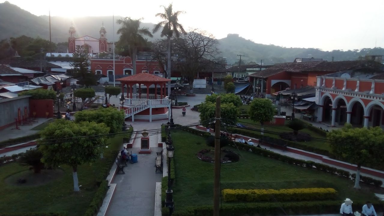


Town Coyutla, Veracruz Totonacapan
A Totonac town in the Sierra de Papantla known for embroidered quechquémitls, carved masks and voladores at its fiestas.
From Poza Rica: 1 h 10 min by car (54 km by road) How to get there ↓
Near here
See everything nearby ↓


Plan your visit to Coyutla
Where to stay near Coyutla
Zozocolco, 14 km away, is the closest town with places to stay.
Compare hotels, posadas and guest houses in Coyutla.
Tours to Coyutla
Day trips around Zozocolco sometimes stop in Coyutla; a tour is the easy way to see it without a car.
How to get to Coyutla
- From Poza Rica: about 1 h 10 min by road (~54 km)
- 14 km northwest of Zozocolco
- Nearest airport: Poza Rica (PAZ), 3 h 15 min by car to Zozocolco
Links open a partner site. We may earn a commission if you book, at no cost to you.
About Coyutla
Coyutla is a municipal town in the hills of the Sierra de Papantla, northwest of Zozocolco, with around 20,000 people in the municipality, most of them Totonac. It is one of the places in the region where traditional dress is still worn by many men and women, and it is best known for its textiles.
Women here embroider the quechquémitl, a short triangular cape worn over the blouse, along with blouses in bright colors. Other local crafts include carved wooden masks for the dances, wooden furniture and pottery. Market days and fiestas are the best times to see them.
The two big celebrations are for Saints Peter and Paul in late June and for Saint Andrew, the patron saint, at the end of November. Both bring processions, traditional dances and the voladores, who climb a tall pole and descend in slow circles hanging from ropes. Outside fiesta time it is a quiet sierra town, and the drive there winds through coffee and corn country with wide views of the hills.
How to get to Coyutla
Drive from Poza Rica: 1 h 10 min, 54 km
Coyutla is roughly 45 minutes to an hour from Zozocolco by car on mountain roads heading northwest. The roads are winding and slow, especially in the rainy season, so allow extra time.
14 km northwest of Zozocolco
Directions from Zozocolco on Google Maps
Distances are in a straight line; the road is usually longer.
Links open a partner site. We may earn a commission if you book, at no cost to you.
From the nearest cities to Coyutla
- Poza Rica · 54 km by road, 1 h 10 min
- Papantla · 61 km by road, 1 h 10 min
- Huauchinango · 76 km by road, 1 h 35 min
Drive times by road from OpenStreetMap, without traffic or stops. Times marked ~ are estimated from the straight-line distance.
Before you go to Coyutla: hours, prices and tips
- Best season
- The big fiestas are for Saints Peter and Paul in June and St Andrew in November; the voladores traditionally fly from the tall pole beside the church in the town centre. MexicanTextiles.com · checked Oct 2026
Hours and prices change, especially around holidays. Each fact links to where we checked it.
Visiting Coyutla: what to see and do
Look for embroidered quechquémitls and blouses made by local women.
Visit during the fiesta of San Pedro and San Pablo in late June or San Andrés in late November to see dances and the voladores.
Browse carved dance masks, furniture and pottery.
Enjoy the views of the sierra on the winding drive from Zozocolco.
Plan your trip
Places to stay in Coyutla
Compare hotels, posadas, and rentals in and around Coyutla.
Tours & activities
Day trips around Zozocolco sometimes stop in Coyutla; a tour is the easy way to see it without a car.
Rental cars
Pick up a car at PAZ (Poza Rica): about 3 h 15 min by road to Zozocolco, then 14 km more to Coyutla, on your own schedule.
Flights
The nearest airport with scheduled flights is Poza Rica (PAZ), about 3 h 15 min by road from Zozocolco, the base for Coyutla.
Mobile data
Signal can drop away from Zozocolco: download a map of the way to Coyutla before you set out, or carry an eSIM with data.
Links open a partner site. We may earn a commission if you book, at no cost to you.
Photos
When to go to Coyutla warm
Coyutla shares the climate of Zozocolco, 14 km away. The best months to visit are February, March, November, and December.
See the month-by-month climate of Zozocolco
Weather in Coyutla now and the next 7 days
Live forecast from Open-Meteo. Chance of rain is the day's highest.
Make Zozocolco your base

Coyutla is an easy trip from Zozocolco, a Pueblo Mágico with places to stay, food, and more to see.
Also close to
- Cuetzalan · Puebla · 29 km away
- Xicotepec · Puebla · 33 km away
- Papantla · Veracruz · 41 km away
- Huauchinango · Puebla · 42 km away
- Tlatlauquitepec · Puebla · 47 km away
Closest to Coyutla
-
Cerro Grande · Village · 3 km away · Veracruz
-
Progreso de Zaragoza · Village · 6 km away · Veracruz
-
Coxquihui · Town · 10 km away
-
Dimas López · Village · 10 km away · Puebla
-
Jopala · Village · 10 km away · Puebla
-
Buenos Aires · Village · 14 km away · Puebla
-
Huehuetla · Town · 16 km away · Near Cuetzalan
-
Olintla · Village · 16 km away · Puebla

Near Coyutla





Drive times by road from OpenStreetMap, without traffic. Times marked ~ are estimated from the straight-line distance.
Something wrong or missing on this page? Suggest a fix or addition
Location from OpenStreetMap. Written by Puebloteca.