
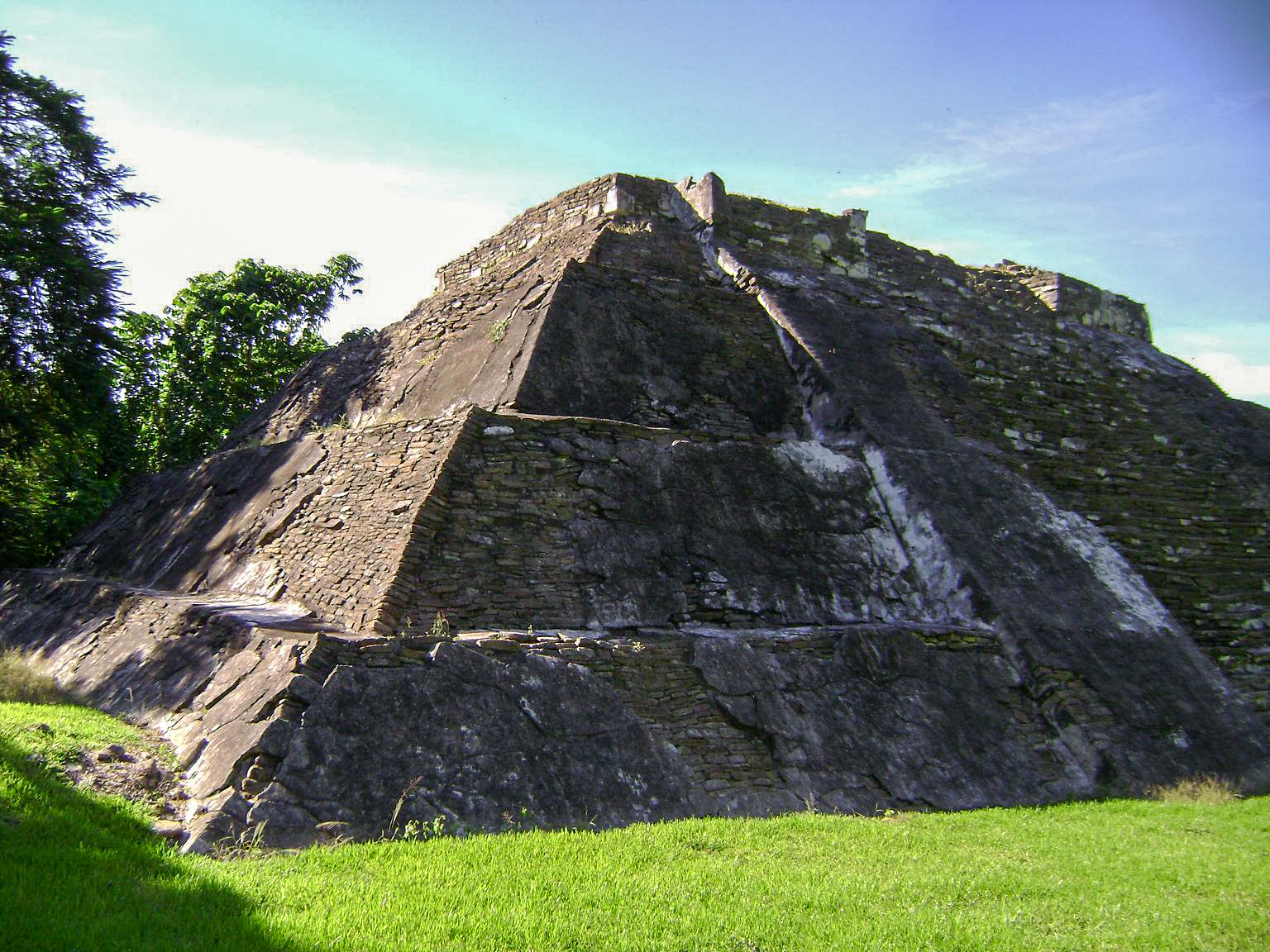


Archaeological site Papantla, Veracruz Municipality of Papantla Totonacapan
A small Totonac city founded as El Tajín declined, with a pyramid at the edge of a cliff and a large ball court.
From Papantla: 35 min by car (32 km by road) How to get there ↓
Near here
See everything nearby ↓


Plan your visit to Cuyuxquihui
Where to stay near Cuyuxquihui
Papantla, 17 km away, is the closest town with places to stay.
Tajín Hotel · ★★★ · 480 m from the center Prices Totonacapan Hotel · ★★ · 210 m from the center PricesTours to Cuyuxquihui
A guide brings Cuyuxquihui to life: look for tours from Papantla that include the site and the ride there.
How to get to Cuyuxquihui
- From Papantla: about 35 min by road (~32 km)
- 17 km southeast of Papantla
- Nearest airport: Poza Rica (PAZ), 2 h 45 min by car to Papantla
Links open a partner site. We may earn a commission if you book, at no cost to you.
About Cuyuxquihui
Cuyuxquihui is a small archaeological site in the Tecolutla River valley, southeast of Papantla and about 22 kilometers from El Tajín. It was founded around 1250 AD, when El Tajín had already lost its power, and it became one of the Totonac centers of the centuries before the Spanish conquest. The name is usually explained as Totonac for "armadillo wood".
The city was built with defense in mind. Retaining walls run along the hill and a cliff protects its eastern side, which is why it is often described as a fortress. Around 1465 it was conquered by the Mexica under Moctezuma Ilhuicamina, and the buildings show a mix of Totonac, Mexica and Huastec styles from that later period.
The site covers about 30 hectares. Its main pyramid rises in four tiers and still has traces of its original stucco, another building keeps a stone monolith about two meters tall, and a long, narrow I-shaped ball court lies a little apart from the rest. It sees only a handful of visitors, so it makes a quiet contrast to the crowds at El Tajín.
How to get to Cuyuxquihui
Drive from Papantla: 35 min, 32 km
Cuyuxquihui is about 40 minutes to an hour by car from Papantla, heading southeast toward Paso del Correo; the site lies about 5 kilometers beyond that village on a local road. There is no regular public transport to the site, so go by car or taxi. Published opening days and hours differ between sources and the site has kept shorter hours than El Tajín, so check with INAH before you go and bring water.
17 km southeast of Papantla
Directions from Papantla on Google Maps
Distances are in a straight line; the road is usually longer.
Links open a partner site. We may earn a commission if you book, at no cost to you.
From the nearest cities to Cuyuxquihui
- Papantla · 32 km by road, 35 min
- Poza Rica · 50 km by road, 50 min
- Martínez de la Torre · 71 km by road, 1 h 10 min
Drive times by road from OpenStreetMap, without traffic or stops. Times marked ~ are estimated from the straight-line distance.
Before you go to Cuyuxquihui: hours, prices and tips
- Hours
- Open Tuesday to Saturday, 10 am to 3:30 pm; closed Sunday and Monday. INAH · checked Oct 2026
- Entry
- 145 pesos for foreign visitors, 80 for Mexican visitors. INAH · checked Oct 2026
- Rules
- No smoking, no food brought in, and no pets. INAH · checked Oct 2026
Hours and prices change, especially around holidays. Each fact links to where we checked it.
Visiting Cuyuxquihui: what to see and do
Walk around the four-tiered main pyramid and look for the remains of its original stucco.
Find the stone monolith of about two meters in one of the smaller buildings.
Visit the long, narrow ball court, set a little apart from the main group.
Look out from the edge of the site over the cliff and the Tecolutla River valley.
Plan your trip
Places to stay in Cuyuxquihui
Compare hotels, posadas, and rentals in and around Cuyuxquihui.
Tours & activities
A guide brings Cuyuxquihui to life: look for tours from Papantla that include the site and the ride there.
Rental cars
Pick up a car at PAZ (Poza Rica): about 2 h 45 min by road to Papantla, then 17 km more to Cuyuxquihui, on your own schedule.
Flights
The nearest airport with scheduled flights is Poza Rica (PAZ), about 2 h 45 min by road from Papantla, the base for Cuyuxquihui.
Mobile data
Signal can drop away from Papantla: download a map of the way to Cuyuxquihui before you set out, or carry an eSIM with data.
Links open a partner site. We may earn a commission if you book, at no cost to you.
Photos
When to go to Cuyuxquihui warm
Cuyuxquihui shares the climate of Papantla, 17 km away. The best months to visit are February, March, April, and December.
See the month-by-month climate of Papantla
Weather in Cuyuxquihui now and the next 7 days
Live forecast from Open-Meteo. Chance of rain is the day's highest.
Make Papantla your base

Cuyuxquihui is an easy trip from Papantla, a Pueblo Mágico with places to stay, food, and more to see.
Also close to
- Zozocolco · Veracruz · 39 km away
- Cuetzalan · Puebla · 43 km away
- Teziutlán · Puebla · 52 km away
- Tlatlauquitepec · Puebla · 57 km away
- Xicotepec · Puebla · 74 km away
Closest to Cuyuxquihui
-
El Tajín · Archaeological site · 20 km away
-
San José Acateno · Village · 20 km away · Puebla
-
Gutiérrez Zamora · Town · 24 km away
-
Ayotoxco de Guerrero · Village · 29 km away · Puebla
-
Poza Rica de Hidalgo · City · 32 km away · Veracruz
-
Tecolutla · Town · 32 km away
-
Corralillos · Village · 34 km away · Veracruz
-
Coxquihui · Town · 37 km away · Near Zozocolco


Near Cuyuxquihui




Drive times by road from OpenStreetMap, without traffic. Times marked ~ are estimated from the straight-line distance.
Lists with Cuyuxquihui
Ruins in Veracruz · 5 Ruins near Poza Rica · 3 Ruins near Martínez de la Torre · 4 Ruins near Cuetzalan · 5 Ruins near Teziutlán · 4Something wrong or missing on this page? Suggest a fix or addition
Location from OpenStreetMap. Written by Puebloteca.