
Town Chalchicomula de Sesma, Puebla Municipality of Chalchicomula de Sesma
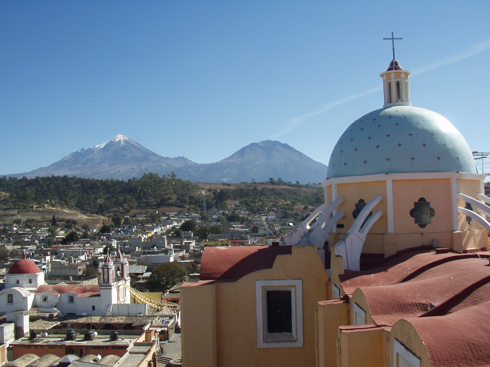
The former San Andrés Chalchicomula, at 2,520 m below Pico de Orizaba and Sierra Negra, with colonial mansions and an all-night procession in August.
From Orizaba: 50 min by car (61 km by road) How to get there ↓
Near here
See everything nearby ↓


Plan your visit to Ciudad Serdán
Where to stay near Ciudad Serdán
Compare hotels, posadas and guest houses in Ciudad Serdán.
Tours to Ciudad Serdán
Day trips around Orizaba sometimes stop in Ciudad Serdán; a tour is the easy way to see it without a car.
 Tours from Puebla City
Africam Safari Zoo Admission with Transportation
★ 4.8 (87) · From US$35
How to get to Ciudad Serdán
- From Orizaba: about 50 min by road (~61 km)
- Nearest airport: Veracruz (VER), 1 h 42 min by car to Orizaba
Links open a partner site. We may earn a commission if you book, at no cost to you.
Tours from Puebla City, near Ciudad Serdán


Tours, prices and ratings from Viator, checked weekly. We may earn a commission if you book.
About Ciudad Serdán
Many people in the area still call it San Andrés, or San Andrés Chalchicomula. Ciudad Serdán sits at 2,520 m in eastern Puebla, and from its rooftops you look straight at Citlaltépetl, or Pico de Orizaba, 19.5 km away in a straight line, and at Sierra Negra, 14 km away, whose summit holds the Large Millimeter Telescope. Almost two thirds of the municipality is flat land, the Llanos de San Andrés, which soak up the meltwater coming off the volcano.
There is no founding charter. The usual starting point is a decree by Viceroy Luis de Velasco dated 17 October 1560, which confirmed the right of the valley's indigenous people to farm their land as cattle ranches spread. In colonial times the town was a granary and a relay post on the royal road between Veracruz, Puebla and Mexico City, where stagecoaches changed teams. Morelos made it his headquarters in 1811 and 1812, staying in Antonio Sesma's house, and Mariano Matamoros held it in 1813.
The name changed twice: on 31 August 1910 it became Chalchicomula de Sesma, after that family of insurgents, and on 23 August 1934 Ciudad Serdán, after Aquiles and Máximo Serdán. Gustavo Díaz Ordaz, president from 1964 to 1970, was born here. Many foreign merchants settled in the 19th century, and mansions such as the Casa de la Magnolia (1820) and Casa Macón (1862) date from then. The Orizaba earthquake killed hundreds in the city and damaged thousands of homes.
The big event is the feast of Padre Jesús de las Tres Caídas: twelve days of serenades in the churchyard, then, on the last Sunday of August, an overnight procession of about eight hours along some 3.5 km of streets laid with carpets, led by the negritos dancers from La Gloria. A livestock show runs at the same time. Local dishes include chileatole, triangular tlaxcales, mushroom texmole and broad-bean soup, with corn cake and tejocote preserves to finish.
How to get to Ciudad Serdán
Drive from Orizaba: 50 min, 61 km
From Puebla city it is about 107 km and 1 h 30 min by car: highway 150D toward Orizaba, then the Cuapiaxtla–Cuacnopalan highway and, at the end, about 9 km of state road into town. From Orizaba it is about 70 km and 1 hour: climb the 150D and then take federal highway 144 north. Ciudad Serdán has an ADO bus station, and the Busbud planner lists AU departures to Mexico City and Puebla; check times before you travel. The Mexico City–Esperanza–Veracruz railway has a station here.
Directions to Ciudad Serdán on Google Maps
Distances are in a straight line; the road is usually longer.
Links open a partner site. We may earn a commission if you book, at no cost to you.
From the nearest cities to Ciudad Serdán
Drive times by road from OpenStreetMap, without traffic or stops. Times marked ~ are estimated from the straight-line distance.
Visiting Ciudad Serdán: what to see and do
The parish church of Jesús de las Tres Caídas, from 1600, and the volcano view from its tower.
The town hall, a colonial mansion from 1730.
The Portal Jiménez de la Cueva (1795) and the Sesma house (1780).
The 1750 tithe house (Colecturía) and the Manuel M. Flores theatre.
The Regional Museum in the Casa de la Cultura.
The old haciendas of Santa Ana, in town, and San Cayetano, 3 km out.
The overnight Padre Jesús procession on the last Sunday of August.
Plan your trip
Places to stay in Ciudad Serdán
Compare hotels, posadas, and rentals in and around Ciudad Serdán.
Tours & activities
Day trips around Orizaba sometimes stop in Ciudad Serdán; a tour is the easy way to see it without a car.
Rental cars
Pick up a car at VER (Veracruz): about 1 h 42 min by road to Orizaba, then 39 km more to Ciudad Serdán, on your own schedule.
Flights
The nearest airport with scheduled flights is Veracruz (VER), about 1 h 42 min by road from Orizaba, the base for Ciudad Serdán.
Mobile data
Signal can drop away from Orizaba: download a map of the way to Ciudad Serdán before you set out, or carry an eSIM with data.
Links open a partner site. We may earn a commission if you book, at no cost to you.
When to go to Ciudad Serdán mild
Ciudad Serdán shares the climate of Orizaba, 39 km away. The best months to visit are February, March, April, and December.
See the month-by-month climate of Orizaba
Weather in Ciudad Serdán now and the next 7 days
Live forecast from Open-Meteo. Chance of rain is the day's highest.
The closest Pueblo Mágico: Orizaba

Orizaba is the Pueblo Mágico closest to Ciudad Serdán, with places to stay, food, and more to see.
Also close to
- Coscomatepec · Veracruz · 43 km away
- Córdoba · Veracruz · 55 km away
- Ixtenco · Tlaxcala · 59 km away
- Huamantla · Tlaxcala · 62 km away
- Xico · Veracruz · 68 km away
Closest to Ciudad Serdán
-
Santa Cruz El Veladero · Village · 4 km away
-
Ahuatepec del Camino · Village · 6 km away
-
San Juan Arcos Ojo de Agua · Village · 6 km away
-
Aljojuca · Village · 15 km away
-
Bellavista de Victoria · Village · 15 km away
-
Cuesta Blanca · Village · 15 km away
-
San Juan Atenco · Village · 15 km away
-
Tlachichuca · Town · 15 km away


Near Ciudad Serdán




Drive times by road from OpenStreetMap, without traffic. Times marked ~ are estimated from the straight-line distance.
Location from OpenStreetMap. Written by Puebloteca.