Town Terrenate, Tlaxcala La Malinche
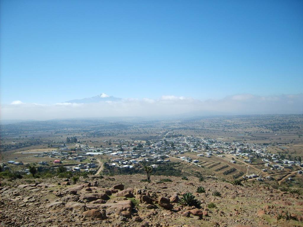
Farming town in Tlaxcala's high northeast at 2,680 m, ringed by old pulque haciendas such as San Pedro Tenexac; San Nicolás fiesta on 10 September.
From Huamantla: 25 min by car (24 km by road) How to get there ↓
Near here
See everything nearby ↓



Plan your visit to Terrenate
Where to stay near Terrenate
Compare hotels, posadas and guest houses in Terrenate.
Tours to Terrenate
Day trips around Huamantla sometimes stop in Terrenate; a tour is the easy way to see it without a car.
 Tours from Puebla City
Africam Safari Zoo Admission with Transportation
★ 4.8 (87) · From US$35
How to get to Terrenate
- From Huamantla: about 25 min by road (~24 km)
- Nearest airport: Puebla (PBC), 1 h 5 min by car to Huamantla
Links open a partner site. We may earn a commission if you book, at no cost to you.
Tours from Puebla City, near Terrenate


Tours, prices and ratings from Viator, checked weekly. We may earn a commission if you book.
About Terrenate
San Nicolás Terrenate is the seat of Terrenate municipality in the far northeast of Tlaxcala, the highest part of the state: the town sits at 2,680 metres, and to the north rise the forested La Caldera hills on the border with Puebla. It had 5,643 people at the 2020 census. It lives from farming, maize, beans, broad beans, potatoes, wheat and barley, plus livestock, and the municipality sends many migrants to the United States.
There are two explanations for the name. One reads it as a Spanish-Nahuatl hybrid, "land the colour of masa"; the other derives it from Otomí Tir näthe, "where the water runs", since the original people here were Otomí. Parish tradition gives the town's old name as Tlallicitlalli, "land of stars". The area was settled between AD 100 and 650, with sites at Los Ameles and the La Candelaria hacienda. Haciendas appear in a census of 1712, when Terrenate belonged to the district of Huamantla, and it became a municipality in 1862. Gerzayn Ugarte, private secretary to President Venustiano Carranza who was with him at Tlaxcalantongo in 1920, was born here. In 1995 the villages that now form the municipalities of Emiliano Zapata and Lázaro Cárdenas were split off from Terrenate.
The parish church of San Nicolás de Tolentino was founded by the Augustinians; its records begin in 1655. It is a plain stone church with walls a metre thick, a barrel vault and two towers capped with tiled cupolas. The north tower is a rebuild: the original collapsed after an accidental fireworks explosion on 12 December 1961, during mass. Tradition says the saint's image was found on a hill about 5 km away, at a spot called La Ermita, where it is carried in procession twice a year. The fiesta runs twelve days from 31 August and peaks on 10 September, when the image tours streets laid with sand and sawdust carpets, pilgrims arrive with the Guadalupan torch carried on foot from the Basilica of Guadalupe, fireworks go up and the negritos dance to a single violin. At carnival, dancers go out in masks, palm hats with paper flowers and bells on their legs.
Several former farming and pulque haciendas surround the town. San Pedro Tenexac, from the 18th and 19th centuries, is a historic monument declared by INAH and has been a set for films and telenovelas; others include Concepción La Noria, with mural painting, San Diego Baquedano, with a crenellated granary and towers, and San Francisco Teometitla. Some restored haciendas offer lodging, meals, horse riding and balloon flights. The municipality also includes San José Villarreal, at 3,080 m and known for its potatoes.
How to get to Terrenate
Drive from Huamantla: 25 min, 24 km
Terrenate is about 48 km from Tlaxcala city: take federal highway 117 from Tlaxcala to Apizaco, then highway 136 towards Huamantla, turning off on the Huamantla-Terrenate state road. Huamantla, the nearest Pueblo Mágico, is about 20 km to the south. By public transport, ATAH and Supra run hourly buses from Mexico City's TAPO terminal to Huamantla (about 2 h 15 min to 2 h 30 min), and ATAH also serves Apizaco from the TAPO and from Puebla's CAPU; there are no published schedules for the last stretch to Terrenate, so ask at the Apizaco or Huamantla terminals about local colectivos.
Directions to Terrenate on Google Maps
Distances are in a straight line; the road is usually longer.
Links open a partner site. We may earn a commission if you book, at no cost to you.
From the nearest cities to Terrenate
- Huamantla · 24 km by road, 25 min
- Chiautempan · 42 km by road, 50 min
- San Martín Texmelucan · 69 km by road, 1 h 5 min
Drive times by road from OpenStreetMap, without traffic or stops. Times marked ~ are estimated from the straight-line distance.
Before you go to Terrenate: hours, prices and tips
- Best season
- San Nicolás de Tolentino fiesta from 31 August to 10 September (main day the 10th, with procession, carpets and fireworks); carnival on the Sunday, Monday and Tuesday before Ash Wednesday. Wikipedia (es), Parroquia de San Nicolás de Tolentino (Terrenate) · checked Oct 2026
Hours and prices change, especially around holidays. Each fact links to where we checked it.
Visiting Terrenate: what to see and do
The stone church of San Nicolás de Tolentino, with records from 1655 and tile-capped towers.
The San Nicolás fiesta, 31 August to 10 September, with sawdust carpets and the negritos dance.
The former Hacienda San Pedro Tenexac, a historic monument and film location.
The former haciendas Concepción La Noria and San Diego Baquedano.
The La Caldera hills to the north, for camping and walking.
Plan your trip
Places to stay in Terrenate
Compare hotels, posadas, and rentals in and around Terrenate.
Tours & activities
Day trips around Huamantla sometimes stop in Terrenate; a tour is the easy way to see it without a car.
Rental cars
Pick up a car at PBC (Puebla): about 1 h 5 min by road to Huamantla, then 19 km more to Terrenate, on your own schedule.
Flights
The nearest airport with scheduled flights is Puebla (PBC), about 1 h 5 min by road from Huamantla, the base for Terrenate.
Mobile data
Signal can drop away from Huamantla: download a map of the way to Terrenate before you set out, or carry an eSIM with data.
Links open a partner site. We may earn a commission if you book, at no cost to you.
When to go to Terrenate cool
Terrenate shares the climate of Huamantla, 19 km away. The best months to visit are January, February, November, and December.
See the month-by-month climate of Huamantla
Weather in Terrenate now and the next 7 days
Live forecast from Open-Meteo. Chance of rain is the day's highest.
The closest Pueblo Mágico: Huamantla

Huamantla is the Pueblo Mágico closest to Terrenate, with places to stay, food, and more to see.
Also close to
- Tlaxco · Tlaxcala · 24 km away
- Ixtenco · Tlaxcala · 26 km away
- Tetela de Ocampo · Puebla · 39 km away
- Chignahuapan · Puebla · 40 km away
- Zacatlán · Puebla · 50 km away
Closest to Terrenate
-
San José Villarreal · Village · 6 km away
-
Emiliano Zapata · Town · 8 km away
-
San José de la Laguna · Village · 8 km away
-
Chipilo (Ixtacamaxtitlán) · Village · 9 km away
-
Hacienda Tecoac · Landmark · 11 km away
-
Velazco · Village · 11 km away
-
Benito Juárez · Town · 13 km away
-
Capulac · Village · 13 km away
Near Terrenate



Drive times by road from OpenStreetMap, without traffic. Times marked ~ are estimated from the straight-line distance.
Location from OpenStreetMap. Written by Puebloteca.