Landmark Apan, Hidalgo Municipality of Apan
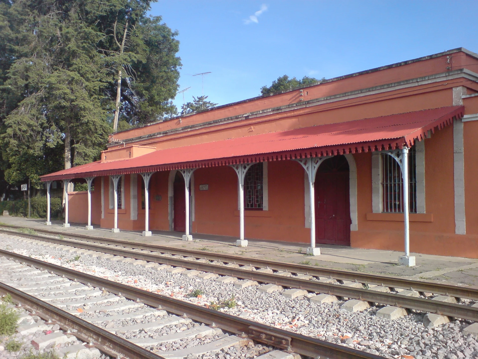
Apan's station opened in 1866 on Mexico's first railway line; today it is a museum of mammoths, pulque and trains.
From Tulancingo: about 50 min by road (~55 km) How to get there ↓
Near here
See everything nearby ↓



Plan your visit to Museo del Ferrocarril de Apan
Where to stay near Museo del Ferrocarril de Apan
Compare hotels, posadas and guest houses in Museo del Ferrocarril de Apan.
Tours to Museo del Ferrocarril de Apan
Look for tours of the area around Otumba that stop at Museo del Ferrocarril de Apan.
 Tours from Zacatlan
Zacatlán Guided Tour walking through the Center
★ 5.0 (2) · From US$8
How to get to Museo del Ferrocarril de Apan
- From Tulancingo: about 50 min by road (~55 km)
- Nearest airport: Mexico City (Felipe Ángeles) (NLU), 43 min by car to Otumba
Links open a partner site. We may earn a commission if you book, at no cost to you.
Tours from Zacatlan, near Museo del Ferrocarril de Apan
Tours, prices and ratings from Viator, checked weekly. We may earn a commission if you book.
About Museo del Ferrocarril de Apan
On 1 August 1866 the Mexican Railway opened its line from Mexico City to Apan to the public, and with it this station, one of the oldest in the country. A first concession for the route had been granted in 1837 and later cancelled; the tracks reached Apizaco in 1867 and the full line to Veracruz, about 424 km, went into service in 1873. Apan's local authorities donated the land for the station, and a warehouse, a loading dock and section workers' houses were built next to it.
The railway transformed the economy of the Llanos de Apan. The pulque haciendas of the plain produced up to about 25,000 litres a day, and some 200 boxcars of pulque left daily along the Mexico City–Veracruz line for the capital's pulquerías and for markets in Puebla and Veracruz; under Porfirio Díaz the hacienda owners went on to dominate the trade through the Compañía Expendedora de Pulques, set up in 1909.
In 2000 the national railway company, Ferrocarriles Nacionales de México, handed the building over to the community, which turned it into a site museum and cultural centre. There are five rooms. The first shows mammoth remains found in the area and Toltec, Teotihuacan and Mexica pottery; the second tells the story of the pulque industry; the third keeps the station's own fittings, such as the departures board, the safe and the ticket window that sold tickets to Mexico City, Puebla and Veracruz; the last two gather photographs and objects from Apan's history. It is a good first stop for making sense of the old hacienda buildings scattered around town, such as Chimalpa, Ocotepec and Tetlapayac, and of why pulque is still part of daily life here.
How to get to Museo del Ferrocarril de Apan
Apan is 1 h 5 min and 70 km by road from Pachuca, and 50 minutes and 58 km from San Martín Texmelucan, the nearest city. From Zempoala, the nearest Pueblo Mágico, it is 40 minutes and 38 km. From Mexico City, Texcoco buses leave the TAPO terminal (San Lázaro metro) for Apan about every 15 minutes and take around two hours; Autobuses Teotihuacan also runs roughly hourly from the Terminal Central del Norte, on a longer trip. The museum occupies the old station beside the tracks, less than a kilometre southwest of central Apan.
Directions to Museo del Ferrocarril de Apan on Google Maps
Distances are in a straight line; the road is usually longer.
Links open a partner site. We may earn a commission if you book, at no cost to you.
From the nearest cities to Museo del Ferrocarril de Apan
- Tulancingo · about 55 km by road, ~50 min
- San Martín Texmelucan · about 60 km by road, ~55 min
- Chiautempan · about 65 km by road, ~1 h
Drive times by road from OpenStreetMap, without traffic or stops. Times marked ~ are estimated from the straight-line distance.
Visiting Museo del Ferrocarril de Apan: what to see and do
The 1866 station building beside the tracks.
The mammoth remains found in the area.
The Toltec, Teotihuacan and Mexica pottery.
The room on the pulque industry.
The original departures board, safe and ticket window.
The photos and objects on Apan's history in the last two rooms.
Plan your trip
Places to stay in Museo del Ferrocarril de Apan
Compare hotels, posadas, and rentals in and around Museo del Ferrocarril de Apan.
Tours & activities
Look for tours of the area around Otumba that stop at Museo del Ferrocarril de Apan.
Rental cars
Pick up a car at NLU (Mexico City (Felipe Ángeles)): about 43 min by road to Otumba, then 31 km more to Museo del Ferrocarril de Apan, on your own schedule.
Flights
The nearest airport with scheduled flights is Mexico City (Felipe Ángeles) (NLU), about 43 min by road from Otumba, the base for Museo del Ferrocarril de Apan.
Mobile data
Signal can drop away from Otumba: download a map of the way to Museo del Ferrocarril de Apan before you set out, or carry an eSIM with data.
Links open a partner site. We may earn a commission if you book, at no cost to you.
When to go to Museo del Ferrocarril de Apan cool
Museo del Ferrocarril de Apan shares the climate of Otumba, 31 km away. The best months to visit are January, February, November, and December.
See the month-by-month climate of Otumba
Weather in Museo del Ferrocarril de Apan now and the next 7 days
Live forecast from Open-Meteo. Chance of rain is the day's highest.
The closest Pueblo Mágico: Otumba

Otumba is the Pueblo Mágico closest to Museo del Ferrocarril de Apan, with places to stay, food, and more to see.
Also close to
- Zempoala · Hidalgo · 33 km away
- Tlaxco · Tlaxcala · 37 km away
- Teotihuacán · Estado de México · 41 km away
- Chignahuapan · Puebla · 47 km away
- Real del Monte · Hidalgo · 53 km away
Closest to Museo del Ferrocarril de Apan
-
Apan · Town · 1 km away
-
Ocotepec · Village · 2 km away
-
Los Voladores · Village · 5 km away
-
Chimalpa Tlalayote · Village · 8 km away
-
Laguna de San Antonio de Atocha · Lagoon · 9 km away
-
Tierra y Libertad · Town · 13 km away
-
Benito Juárez · Town · 14 km away
-
Tepeapulco · Town · 14 km away


Near Museo del Ferrocarril de Apan


Drive times by road from OpenStreetMap, without traffic. Times marked ~ are estimated from the straight-line distance.
Location from OpenStreetMap. Written by Puebloteca.