
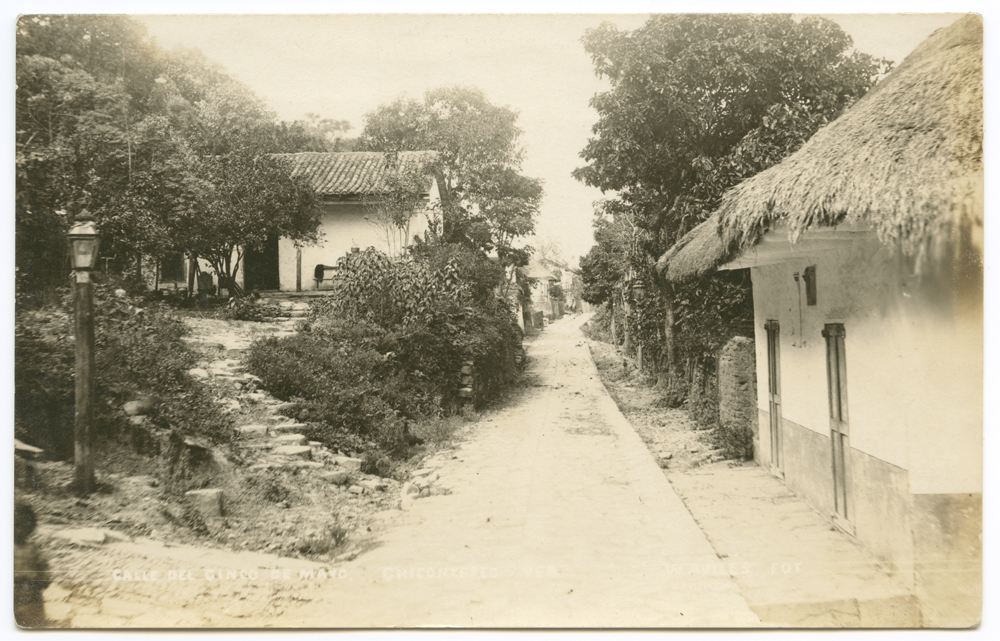
Town Chicontepec, Veracruz Huasteca Veracruzana
A hill town of the Veracruz Huasteca, "the balcony of the Huasteca", at the heart of a Nahua region with Sunday markets and Santa Catarina's fiesta.
From Tuxpan: 1 h 55 min by car (115 km by road) How to get there ↓
Near here
See everything nearby ↓




Plan your visit to Chicontepec
Where to stay near Chicontepec
Compare hotels, posadas and guest houses in Chicontepec.
Tours to Chicontepec
Day trips around Metztitlán sometimes stop in Chicontepec; a tour is the easy way to see it without a car.
 Tours from Xilitla
Surrealist Garden of Edward James, Castle of Health and Xilitla Nativity
★ 4.3 (10) · From US$100
How to get to Chicontepec
- From Tuxpan: about 1 h 55 min by road (~115 km)
- Nearest airport: Mexico City (Felipe Ángeles) (NLU), 2 h 18 min by car to Metztitlán
Links open a partner site. We may earn a commission if you book, at no cost to you.
Tours from Xilitla, near Chicontepec


Tours, prices and ratings from Viator, checked weekly. We may earn a commission if you book.
About Chicontepec
Chicontepec, officially Chicontepec de Tejeda, is the seat of a large municipality in the Huasteca Baja of northern Veracruz, near the border with Hidalgo. It sits at about 520 m on the slopes of the Sierra de Chicontepec, a branch of the Sierra Madre Oriental, and its name comes from Nahuatl chikome tepetl, "seven hills". The town had 4,823 people at the 2020 census, but it is the centre of a mostly rural and Indigenous municipality of nearly 300 localities, where most people are Nahua and some speak Tének (Huastec). The municipal encyclopaedia calls it the "balcony of the Huasteca" for its view over the green plain that runs towards the coast.
Before the Spanish conquest the area belonged to the Huastec province of Zicoac and later paid tribute to the Aztec Triple Alliance. The colonial town was formed by congregating scattered villages from 1592, when the viceroy commissioned Pedro Portes to found it as Santa Catarina Chicontepec. The church was rebuilt in the early 19th century with three naves and was burned during the War of Independence, when its parish archives were lost. Chicontepec belonged to Puebla until 1 December 1853, when it passed to Veracruz. It became a city in 1910, and in 1960 it was renamed Chicontepec de Tejeda after General Adalberto Tejeda Olivares, the revolutionary and governor of Veracruz who was born here.
Chicontepec is above all a market and festival town for the surrounding Nahua villages. On Sundays people come in to sell dried meat, embroidered cloth, tobacco, ground coffee and farm produce, and local crafts include textiles, pottery, rattan, palm and leather. The main fiesta honours Santa Catarina on 24–25 November with dances, religious processions and flower offerings, and Day of the Dead is the most important ritual season of the southern Huasteca. From the town you can see Postectitla, a hill of bluish-grey basalt that is sacred in local Indigenous ritual. Typical dishes include bocoles, zacahuil, enchiladas with cecina and fried enchiladas.
How to get to Chicontepec
Drive from Tuxpan: 1 h 55 min, 115 km
Chicontepec is about 120 km by road from Poza Rica, roughly two hours by car. There is no direct bus from Poza Rica: ADO runs from Poza Rica to Cerro Azul (about 1 hour 30 minutes), and from there you continue by taxi or local transport. The town is about 445 km by road from Xalapa.
Directions to Chicontepec on Google Maps
Distances are in a straight line; the road is usually longer.
Links open a partner site. We may earn a commission if you book, at no cost to you.
From the nearest cities to Chicontepec
- Tuxpan · 115 km by road, 1 h 55 min
- Tulancingo · about 130 km by road, ~1 h 55 min
- Papantla · about 140 km by road, ~2 h
Drive times by road from OpenStreetMap, without traffic or stops. Times marked ~ are estimated from the straight-line distance.
Before you go to Chicontepec: hours, prices and tips
- Best season
- Santa Catarina, the town's patron, 24–25 November with dances and flower offerings; Day of the Dead at the start of November is the region's main ritual season. Enciclopedia de los Municipios de México (INAFED) · checked Oct 2026
Hours and prices change, especially around holidays. Each fact links to where we checked it.
Visiting Chicontepec: what to see and do
Look out over the Huasteca plain from the town known as the balcony of the Huasteca.
Visit the Sunday market, when Nahua villagers bring cecina, embroidery, tobacco and coffee.
See the three-naved parish church of Santa Catarina, rebuilt in the early 19th century.
Come for the Santa Catarina fiesta on 24–25 November, with dances and flower offerings.
Spot Postectitla, the sacred basalt hill, on the skyline.
Try bocoles, zacahuil and enchiladas with cecina.
Plan your trip
Places to stay in Chicontepec
Compare hotels, posadas, and rentals in and around Chicontepec.
Tours & activities
Day trips around Metztitlán sometimes stop in Chicontepec; a tour is the easy way to see it without a car.
Rental cars
Pick up a car at NLU (Mexico City (Felipe Ángeles)): about 2 h 18 min by road to Metztitlán, then 75 km more to Chicontepec, on your own schedule.
Flights
The nearest airport with scheduled flights is Mexico City (Felipe Ángeles) (NLU), about 2 h 18 min by road from Metztitlán, the base for Chicontepec.
Mobile data
Signal can drop away from Metztitlán: download a map of the way to Chicontepec before you set out, or carry an eSIM with data.
Links open a partner site. We may earn a commission if you book, at no cost to you.
When to go to Chicontepec mild
Chicontepec shares the climate of Metztitlán, 75 km away. The best months to visit are January, February, March, and December.
See the month-by-month climate of Metztitlán
Weather in Chicontepec now and the next 7 days
Live forecast from Open-Meteo. Chance of rain is the day's highest.
The closest Pueblo Mágico: Metztitlán

Metztitlán is the Pueblo Mágico closest to Chicontepec, with places to stay, food, and more to see.
Also close to
Closest to Chicontepec
Near Chicontepec







Drive times by road from OpenStreetMap, without traffic. Times marked ~ are estimated from the straight-line distance.
Location from OpenStreetMap. Written by Puebloteca.