
Town Jaltocán, Hidalgo Hidalgo Huasteca
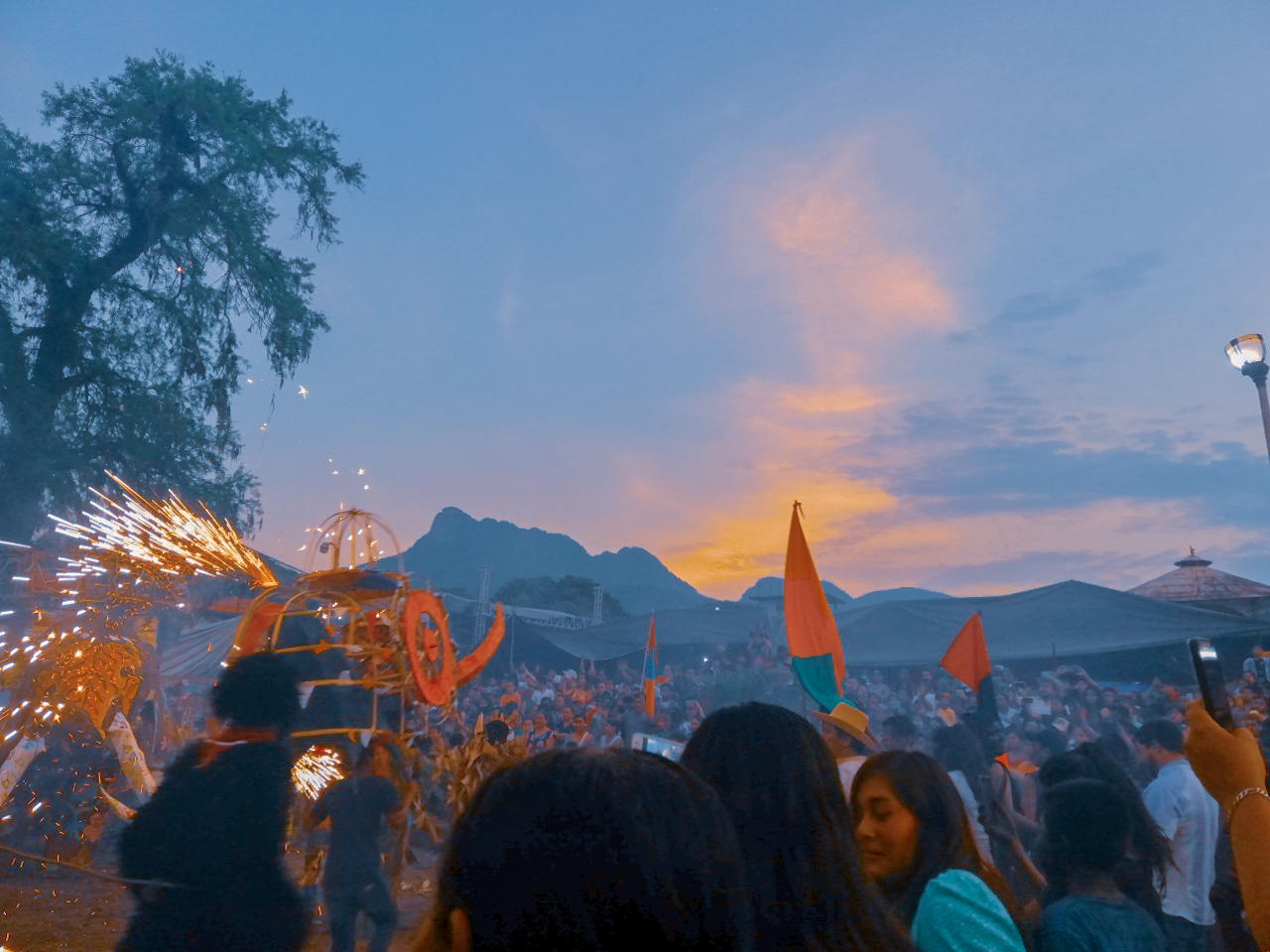
A Nahua Huasteca seat at 199 m, known for embroidery, bread, masks and candles, an intimate Xantolo and a carnival with burning toritos.
From Tulancingo: about 2 h 15 min by road (~155 km) How to get there ↓
Near here
See everything nearby ↓




Plan your visit to Jaltocán
Where to stay near Jaltocán
Compare hotels, posadas and guest houses in Jaltocán.
Tours to Jaltocán
Day trips around Xilitla sometimes stop in Jaltocán; a tour is the easy way to see it without a car.
How to get to Jaltocán
- From Tulancingo: about 2 h 15 min by road (~155 km)
- Nearest airport: Querétaro (QRO), 3 h 27 min by car to Xilitla
Links open a partner site. We may earn a commission if you book, at no cost to you.
About Jaltocán
Jaltocán lies at 199 metres above sea level in the Hidalgo Huasteca, with a warm humid climate, a mean of 23 °C and about 1,750 mm of rain a year. Its Nahuatl name reads "place of sandy ground" or "where one sows in sand"; another reading speaks of a sand flat of spiders. In 2020 the town had 5,919 residents, more than half the municipality, and roughly three in four speak an indigenous language, mainly Nahuatl.
It is known for its artisans: hundreds of people embroider or make bread, candles, masks and other objects, although most residents work in trade. Xantolo here is more home than street. In many houses you smell copal and marigold under the arches before the offerings, and some families leave the door open so the dead can return to eat and drink what they liked. Some women call their dead in Nahuatl while blowing the copal burner over bread, coffee and tamales. As in Tlanchinol, the state government organised catrina and catrín contests, comparsa parades and arch and altar contests here in 2022.
The carnival ends with a ceremony in which toritos and the floats each barrio built are burned, according to the caption of a 2019 photo on Wikimedia Commons; the ceremony carries its Nahuatl name, Xaltocaj.
How to get to Jaltocán
Jaltocán is about 17 km from Huejutla de Reyes by road, roughly 20 minutes by car, and almost every trip is made from there: the municipality is largely surrounded by Huejutla's. Rome2rio puts it at about 15 to 16 km and 17 minutes by car or taxi.
There is no direct bus, according to Rome2rio: take one from Huejutla to Macuxtepetla (about 20 to 24 minutes) and then a taxi to Jaltocán (about 14 minutes). To reach Huejutla from Pachuca, take federal highway 105, which passes through Mineral del Monte, Atotonilco el Grande, Zacualtipán, Molango and Tlanchinol. Xilitla, the nearest Pueblo Mágico, is about 55 km away in a straight line, in San Luis Potosí.
Directions to Jaltocán on Google Maps
Distances are in a straight line; the road is usually longer.
Links open a partner site. We may earn a commission if you book, at no cost to you.
From the nearest cities to Jaltocán
- Huauchinango · about 155 km by road, ~2 h 15 min
- Tulancingo · about 155 km by road, ~2 h 15 min
- Ciudad Valles · 150 km by road, 2 h 25 min
Drive times by road from OpenStreetMap, without traffic or stops. Times marked ~ are estimated from the straight-line distance.
Before you go to Jaltocán: hours, prices and tips
- Best season
- Xantolo begins on 29 September in the Hidalgo Huasteca and its central days run from 30 October to 2 November (1 November for dead children, 2 for adults). In Jaltocán it is a festival of home altars. Criterio Hidalgo · checked Oct 2026
Hours and prices change, especially around holidays. Each fact links to where we checked it.
Visiting Jaltocán: what to see and do
Home Xantolo altars, with marigold arches and copal
The embroidery, bread, candle and mask workshops
The burning of toritos and floats at the end of carnival
The catrina, comparsa, arch and altar contests
The warm Huasteca climate at 199 metres
Plan your trip
Places to stay in Jaltocán
Compare hotels, posadas, and rentals in and around Jaltocán.
Tours & activities
Day trips around Xilitla sometimes stop in Jaltocán; a tour is the easy way to see it without a car.
Rental cars
Pick up a car at QRO (Querétaro): about 3 h 27 min by road to Xilitla, then 55 km more to Jaltocán, on your own schedule.
Flights
The nearest airport with scheduled flights is Querétaro (QRO), about 3 h 27 min by road from Xilitla, the base for Jaltocán.
Mobile data
Signal can drop away from Xilitla: download a map of the way to Jaltocán before you set out, or carry an eSIM with data.
Links open a partner site. We may earn a commission if you book, at no cost to you.
When to go to Jaltocán mild
Jaltocán shares the climate of Xilitla, 55 km away. The best months to visit are February, March, August, and November.
See the month-by-month climate of Xilitla
Weather in Jaltocán now and the next 7 days
Live forecast from Open-Meteo. Chance of rain is the day's highest.
The closest Pueblo Mágico: Xilitla

Xilitla is the Pueblo Mágico closest to Jaltocán, with places to stay, food, and more to see.
Also close to
- Metztitlán · Hidalgo · 65 km away
- Aquismón · San Luis Potosí · 74 km away
Closest to Jaltocán
-
Huichapa · Village · 4 km away
-
Contépec · Village · 5 km away
-
La Corrala · Village · 5 km away
-
Coacuilco · Village · 6 km away
-
Ixcatlán · Village · 6 km away
-
Macuxtepetla · Village · 6 km away
-
Tlaltzintla · Village · 6 km away
-
Orizatlán · Town · 8 km away

Near Jaltocán








Drive times by road from OpenStreetMap, without traffic. Times marked ~ are estimated from the straight-line distance.
Location from OpenStreetMap. Written by Puebloteca.